Best Hikes in Kandersteg
Location: Bernese Oberland
Kandersteg Hiking Trails
Distance: 9.8 - 10.4 miles (Round Trip)
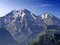
Hikers tackling the steep, strenuous ascent to Hohturli Pass are rewarded with stunning vistas of Oeschinensee Lake, marvelous mountain scenery and close-up views of dramatic glaciers.
Kandersteg (Sunnbuel) to Adelboden ![]()
Distance: 7.3 miles (One Way)
This challenging trail features panoramic views of the high peaks towering above the Spittelmatte, Uschene and Engstligenalp Valleys. The path is best suited for sure footed hikers who like demanding trails that cross exposed passes, travel along airy ridges and include steep ascents and descents.
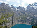
Distance: 5.2 miles (Loop)
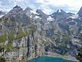
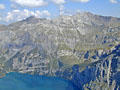
This terrific loop hike features ever-evolving views of the magnificent glacial cirque towering above the Oeschinensee, one of the most beautiful lakes in the Swiss Alps.
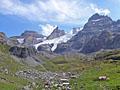
Griesalp to Kandersteg via Hohturli ![]()
Distance: 9.1 miles (One Way)
The challenging hike over Hohturli Pass features captivating vistas of the high peaks towering above the Kiental and Kandertal valleys, front row seats to the dazzling Bluemlisalp Glacier and stunning views of the rugged cirque soaring above the Oeschinensee, one of the most beautiful lakes in Switzerland.
Distance: 10.8 - 12.8 miles (One Way)
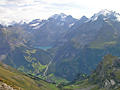
Soaring peaks, a glacier-clad cirque, pretty villages, and nonstop views are the hallmarks of this scenic hike traveling high above the north side of the Lötschental. Views stretch up the length of the panoramic valley and south to the high peaks towering above the Valais.
Distance: 4.0 - 7.3 miles (Loop)
This beautiful hike ascends through scenic meadows with nonstop views of the glacier-clad peaks rising above the upper Lötschental. Along the way the path passes three pretty lakes, travels beside sections of the Lonza River and visits Anenhutte (Anen Hut).
Distance: 3.3 - 8.4 miles (Round Trip)
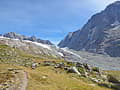
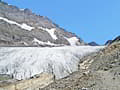
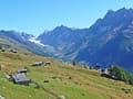
This scenic hike travels up the rugged Gasterntal (Gastern Valley) and then climbs steeply to viewpoints above the Kanderfirn Glacier. Two shorter versions of the hike offer beautiful views of the valley while avoiding the steep ascent to the glacier overlook.
Distance: 5.8 miles (One Way)
This popular, easy segment of the Lötschentaler Höhenweg, a high route along the north side of the Lötschental (Lötschen Valley), travels through lovely meadows, beautiful larch forests and bucolic villages accompanied by panoramic views of the glacier-clad peaks rimming the valley.
Ammerten Pass and the Ammertenspitz ![]()
Distance: 5.5 - 6.5 miles (Round Trip)
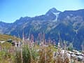
Ascend the beautiful Engstligenalp valley to scenic Ammerten Pass with great views of the peaks surrounding the valley and the mountains rising to the south. From the pass a steep trail leads to the Ammertenspitz summit with panoramic views encompassing the summits towering above Adelboden, Lenk and beyond.
Distance: 10.8 miles (Round Trip)
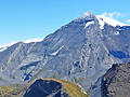
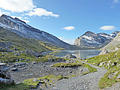
This trail travels up a pretty valley, rimmed by rugged cliffs and soaring peaks, passes the Daubensee, a photogenic lake, and then climbs to Gemmi Pass with panoramic views of the high peaks in the Valais, stretching from Monte Rosa to Dent Blanche and beyond.
Distance: 4.4 miles (Round Trip)
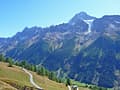
Hikers completing the very steep climb to the summit of the Bunderspitz are rewarded with amazing views of the cirque soaring above the Oeschinensee along with the high peaks towering above the head of the Kandertal and Adelboden (Engstligental) Valleys.
Distance: 7.8 miles (Round Trip)
Trail Closed
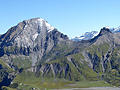
Frunden Hut is set atop a rock knoll beneath the Frundenhorn and Frunden Glacier, over 3,200-ft. above the Oeschinensee, a beautiful lake. Dramatic views from the overlook encompass the Bluemlisalp massif, adorn with glaciers, along with the high peaks towering above the north side of the lake.
Distance: 4.0 miles (Round Trip)
A very steep climb leads to First, a great overlook high above the west side of Kandersteg, with 360-degree views of the high peaks towering above Oeschinensee, Spittelmatte and the Adelboden (Engstligental) Valleys.
Lauchernalp to Faldumalp to Ferden ![]()
Distance: 7.1 miles (One Way)
This hike travels between Lauchernalp, Faldumalp and Ferden on a segment of the Lötschentaler Höhenweg . Highlights include grand views of the glacier-clade peak rimming the Lötschental, lovely meadows, pretty villages, and gushing streams.
View Hikes by Area:
Bernese OberlandGrindelwaldLauterbrunnenGriesalpKanderstegEngelbergMeiringenAltdorf
| Support our Site |