Details: Morning Eagle Falls 
Distance: 6.4 - 9.2 miles (loop)
Glacier National Park, near Many Glacier in Glacier Natl Park, MT
Hike Facts
- Distance: 6.4 - 9.2 miles (loop)
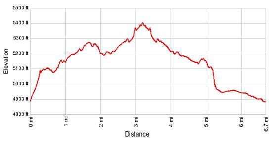
- Elevation: 4,880-ft. - 5,400-ft.
- Elevation Gain: 520-ft.
- Difficulty: moderate
- Trail Highlights: See Trail Intro
- Basecamp(s): Many Glacier / St Mary
- Region: Glacier Natl Park, MT
This pleasant hike visits two pretty waterfalls, Feather Plume Falls and Morning Eagle Falls, in the lovely Cataract Creek Valley. Beyond the falls the trail climbs steeply to Piegan Pass.
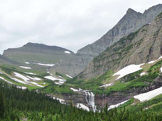
Morning Eagle Falls
From the boat dock at the head of Lake Josephine, a narrow spur trail heads southeast on steep grades for 0.4 miles to a junction with the Piegan Pass trail. Turn right (southwest) on the Piegan Pass trail in the direction of Morning Eagle Falls and Piegan Pass.
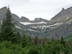
Follow the trail as it makes an ascending traverse through forest and meadows on easy to moderate grades. Openings along the trail offer great views of Mt. Grinnell (8,851-ft.), the Garden Wall, Mount Gould (9,553-ft.) and the Grinnell and Salamander Glaciers to the west. As you proceed views open to a pretty waterfall cascading down the steep cliffs to the west of the trail.
At 1.9 miles the trail starts an easy descent, passing through a lovely meadow. The serrated ridge between the Bishop’s Cap (9,127-ft.) and Mount Gould tower above the west side of the valley. Pretty Feather Plume Falls, a tall horsetail style falls, drops down a sheer cliff between Mt. Gould and Angel Wing (7,430-ft.). At the head of the valley, to the south, Bishop’s Cap, Piegan Mountain (9,220-ft.) and Cataract Mountain (8,180-ft.) dominate the view. (Piegan Pass is located on the unseen saddle between Piegan and Cataract Mountains.)
Arrive at a junction at 2.2 miles. The trail making a sharp turn to the right (north) leads to Grinnell Lake and offers an interesting option for the return leg of the hike. We continue straight ahead toward the head of the valley.
The trail now ascends on easy grades through open forest, crossing a bridge over Cataract Creek at 2.3 miles. As you proceed up the valley, the serrated ridge running between Mount Gould and the Bishop’s Cap soars above the trail to the west.
At 2.8 miles the forest gives way lush meadows and willow thickets. The peaks at the head of the valley form a stunning backdrop for Morning Eagle Falls, plunging down a steep cliff. Allen Mountain (9,376-ft.) and a number of lesser peaks rim the valley to the east.
Cross back to the east side of Cataract Creek on a bridge at 2.9 miles. Deep snow often lingers around this part of the valley. It is now unusual to see snow bridges spanning the creek above the crossing. For safety reason do not try to cross the snow bridges.
Beyond the crossing the trail ascends through stunted conifers and meadows on moderate and then easy grades, reaching the base of Morning Eagle Falls at 3.2 miles. Here multiple cascades spill over a ledge and down a red argillite rock face. The jagged cliffs along the Continental Divide tower overhead.
At this is a good turnaround point for hikers looking for a shorter day. Retrace your steps to the junction with the trail to Grinnell Lake at 4.4 miles. For some variety I highly recommend returning via Grinnell Lake. Bear left at the junction toward the lake, following the trail through open meadows and forest beneath the east face of Angel Wing (7,430-ft.), a small peak rising to the southwest of Grinnell Lake.
Cross Cataract Creek on a swing bridge at 4.75 miles and then follow the trail is it ascends a low wooded ridge. At 5.1 miles the trail starts descending a moderately steep slope on switchbacks. Openings in the trees offer intermittent views of Mt. Grinnell towering over the aquamarine waters of Grinnell Lake. At the base of the switchbacks the trail arrives at a junction with the trail to Grinnell Lake. Turn left at the junction.
Reach pretty Grinnell Lake (5,050-ft.) at 5.4 miles. The lake lies in a dramatic cirque beneath the towering walls of Mt. Gould, the Garden Wall and Mt. Grinnell. Melt water from the Salamander and Grinnell Glaciers spill down a beautiful waterfall and into the western end of Grinnell Lake.
After taking in the views follow the trail heading northeast from the lakeshore, passing the junction with the trail to Feather Plume Falls/Piegan Pass along the way. Travel over boardwalks spanning a marshy section of the trail and then follow the trail through pleasant forest.
Cross Cataract Creek on a swing bridge at 5.7 miles. Only one hiker at a time is allowed on the bridge. Walk with one foot in front of the other to minimize the movement of the bridge and hold onto the hand cables. Just beyond the east side of the bridge a short spur trail on the right climbs switchbacks to Hidden Falls where Cataract Creek rushes down a deep, narrow gorge.
Follow the trail as it travels on easy grades through the forest, crossing boardwalks and briefly traversing alongside Cataract Creek. Reach a trail junction at the southwest end of Lake Josephine at 6.5 miles. The trail to the left swings around the head of the lake. We continue straight ahead for a tenth of a mile to the spur trail leading left to the Oastler Shelter and the boat dock.
Hikers looking for a long day can return to the Many Glaciers Hotel via either the North Shore or South Shore Lake Josephine trails, adding 2.6 - 2.7 miles to the hike, depending on the route. See the hiking description for Grinnell Lake for more information on the trials around Lake Josephine..
Piegan Pass Option
Beyond Morning Eagle Falls the trail ascends steep to moderately steep switchbacks through stunted conifers and pretty meadows up the east side of the valley, climbing beside a branch of Cataract Creek tumbling down narrow crevasses carved into the rocky hillside. The trail crosses the creek at 4.2 miles and then continues the ascending traverse through alpine meadows and talus slopes, reaching Piegan Pass at 6.4 miles. The climb from the falls to the pass gains over 2,000-ft. in just under 3.2 miles.
Cross to the south side of the broad pass for excellent views of Mt. Siyeh (10,014-ft.), Matahpi Peak (9,365-ft.) and the Going-to-the-Sun Mountain (9,642-ft.). Pollock Mountain (9,190-ft.) looms above the pass to the west. When you are done taking in the views to the south, return to the north side of the pass. Drop down the trail for a short distance (0.1.miles) to the top of the first switchback where use trails head west to scenic perches high above the Cataract Creek Valley. From this vantage point enjoy stunning views of the peaks along the Garden Wall on the Continental Divide, including the Bishop’s Cap and Mount Gould (9,553-ft.), towering above the west side of the valley. Distant views extend north to Mount Grinnell (8,851-ft.), Mt. Wilbur (9,321-ft.) and Mt. Henkel (8,770-ft.) in the Many Glacier area.
Piegan Pass can also be accessed via a very scenic hike from the south along the Going to the Sun Road. See the Piegan Pass hiking description for more information.
Elevation Profile
Driving Directions
From St. Mary: Drive north on US 89 for 8.5 miles and turn left onto Route 3, signed for Many Glacier. The turn is just before the town of Babb, MT. Continue along Route 3 for 11.9 miles to the Grinnell Glacier trailhead at the Many Glacier Picnic area, located on the left (south) side of the road.
From the Many Glacier Hotel Complex: Head west on Route 3 for 0.5 miles to the Grinnell Glacier trailhead at the Many Glacier Picnic area, located on the left (south) side of the road.
To the Many Glacier Hotel Complex and the Boat Dock:
From St. Mary: Drive north on US 89 for 8.5 miles and turn left onto Route 3, signed for Many Glacier. The turn is just before the town of Babb, MT. Continue along Route 3 for 11.4 miles and turn left on the road leading to the Many Glacier Hotel. In a short distance make a second left on the road leading up the hill to the large parking lot in the rear of the complex. Walk through or around the hotel to the boat dock on the west side of the building.
Via Boat: The Glacier Park Boat Company (http://www.glacierparkboats.com/) runs boat tours of Swiftcurrent and Josephine Lakes. Hikers can ride the boats either one way to round trip to shorten hiking distances. The two stage boat trip starts from the west side (lake side) of the Many Glacier Hotel and cross Swiftcurrent Lake. At the end of the lake tour participants disembark and walk 400 yards to the foot of Josephine Lake where a second boat awaits to take the tour to the head to the head of Josephine Lake. At the head of Josephine Lake trails connect to destinations in the Grinnell Valley and Morning Eagle Falls/Piegan Pass. See the Glacier Park Boat Company (http://www.glacierparkboats.com/) website for schedules and costs.
Trail Resources
Trail Intro / Trail Photo Gallery / Trail Map
Basecamp(s) Information:
Many Glacier / St Mary
Region Information:
Glacier Natl Park, MT
Other Hiking Regions in:
Montana