Best Hikes in California's Southwestern Sierra
Location: 270 miles southwest of San Francisco, CA and 230 miles north of Los Angeles, CA
By: Diane Greer
Featured Hikes
Distance: 13.8 miles (Round Trip)
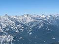
Alta Peak offers some of the best views in the southern Sierras. From its lofty summit breath-taking vistas extend from the Sierra Crest, the Great Western Divide and the Kaweah Peaks to the foothills of the San Joaquin Valley.
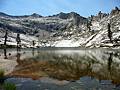
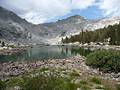
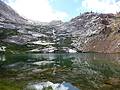
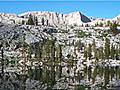
Lakes Trail - Heather, Emerald and Pear Lakes ![]()
Distance: 8.2 - 12.8 miles (Round Trip)
The Lakes Trail, one of the most popular hikes in Sequoia National Park, climbs through dense forest to a landscape of polished granite dotted with four beautiful lakes and set amid a backdrop of rugged ridges anchored by Alta Peak (11,204-ft.).
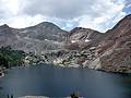
Distance: 6.4 miles (Round Trip)
This short, strenuous hike climbs to a pretty lake nestled in a rugged cirque, with great views of the East Fork Kaweah River valley and the Great Western Divide en route.
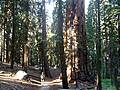
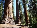
Distance: 3.0 - 7.6 miles (Loop)
This great loop hike through the heart of the aptly named Giant Forest visits some of the world’s largest trees and traverses amazing groves of these stately giants.
Distance: 9.0 miles (Round Trip)
Beautiful Monarch Lakes lie cradled in scenic bowl at the foot of Sawtooth and Mineral Peaks. A moderately-steep trail to the lake climbs through meadows, red fir forest and avalanche-scoured slopes and features fine views of the Mineral King valley.
Distance: 12.0 miles (Round Trip)
This popular day hike climbs to Lower Franklin Lake, nestled in a scenic basin beneath the Great Western Divide.
Distance: 7.3 - 9.6 miles (Loop)
Leave the crowds behind and enjoy a peaceful hike through one of Sequoia-Kings Canyon National Park’s largest sequoia groves.
Distance: 7.4 - 9.2 miles (Round Trip)
Multi-hued rugged canyon walls, pretty meadows sprinkled with wildflowers and a dramatic glacial cirque are the scenic delights of this great hike up White Chief Canyon
Distance: 7.2 - 9.0 miles (Round Trip)
This trail follows the path to Eagle Creek for the first 2 miles and then crosses Miner’s Ridge to the Mosquito Lake #1, a small, shallow lake surrounded by red firs. A use trail leads to Lake # 2, a beautiful alpine gem cradled in a granite basin. Use trails and cross-country routes climb the rocky basin to the other three lakes.
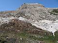
Distance: 4.5 miles (Round Trip)
This very steep hike offers great views of the Mineral King Valley and a good workout.
View Hikes by Area:
LodgepoleMineral King
The Region, the Hikes & the Base Camps
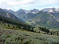
Giant sequoias, peaceful conifer forests, glistening lakes and dramatic mountain scenery tempt hikers to explore the southwestern Sierra Nevada Mountains around Lodgepole and Mineral King in Sequoia-Kings Canyon National Park.
Base Camp Information:
LodgepoleMineral King