Best Hikes in Meiringen
Location: Bernese Oberland
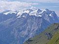
Meiringen Hiking Trails
Distance: 6.4 miles (One Way)
Difficulty: moderate-strenuous
The beautiful hike from Engstlenalp to Planplatten visits the scenic Tannersee, enjoys terrific views atop the Balmeregghorn and then travels to the overlook at Planplatten with panoramic vistas of the high peaks towering above four valleys.

Distance: 5.2 miles (Round Trip)
Difficulty: moderate
A visit the Oberaar Glacier combines a scenic gondola ride with a great hike that travels through wildflower-filled meadows besides the Oberaar Lake as it ascends the beautiful Oberaar Valley to the tongue of the glacier, set beneath the magnificent cirque at the head of the valley.
View Hikes by Area:
Bernese OberlandGrindelwaldLauterbrunnenGriesalpKanderstegEngelbergMeiringenAltdorf
| Support our Site |