Best Hikes in Saas Fee
Location: Valais
Saas Fee Hiking Trails
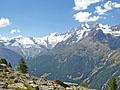
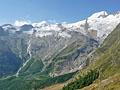
Gspon to Kreuzboden (Gspon Hohenweg) ![]()
Distance: 8.6 miles (One Way)
Difficulty: moderate-strenuous
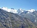
The Gspon Hohenweg is another of the great high routes in the Saas Valley. This scenic trail, traversing high above the east side of the valley, features wonderful panoramic views of the 13,000-ft. (4,000-meter) peaks of the Mischabel Range.
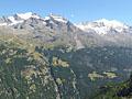
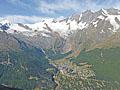
Grachen to Saas Fee (Hohenweg Saas Fee) ![]()
Distance: 10.8 miles (One Way)
Difficulty: strenuous
The Saas Fee Hohenweg is one of the classic hikes in the Valais. The challenging trail follows a high route along the west side of the Saastal with stunning, nonstop views of the glacier-clad peaks towering above the Saas Valley and the Bernese Alps to the north.
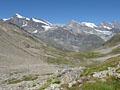
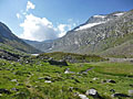
Mattmark to Heidbodme via Jazzilucke ![]()
Distance: 9.6 - 10.8 miles (One Way)
Difficulty: strenuous-difficult
An great hike traversing two beautiful valleys connected by a challenging, exposed trail traveling between the Jazzilucke and Antrona passes on the Swiss-Italian border.
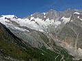
Kreuzboden to Saas Almagell (Hohenweg Kreuzboden) ![]()
Distance: 6.0 - 6.3 miles (One Way)
Difficulty: moderate
This scenic walk, with panoramic views of the Mischabel Range, traverses high above the east side of the Saas Valley before entering the beautiful Almageller Valley. End the hike by descending to Saas Almagell or take the challenging Adventure Trail to Furggstalden.
Distance: 10.4 miles (Round Trip)
Difficulty: moderate-strenuous
A lovely walk up a pretty valley leads to a remote and wild saddle on the Swiss-Italian border, offering a degree of solitude not found on many hikes around the Saas Fee area.
Hannig to Saas Fee (Gemsweg Part 1) ![]()
Distance: 4.0 miles (One Way)
Difficulty: moderate
Few trails in the Saas Fee area feature the scenic bang for the miles hiked as the Gemsweg (Chamois Path) from Hannig to Saas Fee. A glacial lake, glistening waterfalls and ever changing views of the high peaks towering above Saas Fee are just a few of the highlights along this delightful trail.
Plattjen to Saas Fee (Gemsweg Part 2) ![]()
Distance: 3.9 miles (One Way)
Difficulty: moderate
Great views of the Mischabel peaks towering above Saas Fee and the Saas Valley are the highlights of this short trail descending from Plattjen to Saas Fee along the Gemsweg.
Distance: 10.4 miles (Round Trip)
Difficulty: strenuous
This trail starts at the scenic overlook at Heidbodme, with panoramic views of the peaks towering above the Saastal. The path then travels on a high route along the eastern slopes of the Furgg Valley to Antrona Pass, a remote and wild saddle on the Swiss-Italian border.
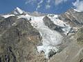
Mellig, Gibidum and the Bider Glacier ![]()
Distance: 2.7 - 6.4 miles (Loop)
Difficulty: moderate-strenuous
Two lofty overlooks offer impressive bird’s-eye views of the glacial cirque surrounding Saas Fee, the Hohblam Glacier and the Fletschhorn-Weissmies group. The return to Saas Fee features views of the Bider Glacier and a walk through a pretty forest.
View Hikes by Area:
ValaisZermattSaas FeeGrubenZinalLes HauderesArolla
| Support our Site |