Best Hikes in Central Colorado
Location: 41 miles southeast of Glenwood Springs, 100 miles southwest of Denver and 28 miles north of Gunnison.
Featured Hikes
Distance: 3.4 - 9.2 miles (Round Trip)
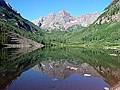
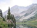
This popular trail climbs to a 12,462-ft. pass with panoramic views of the 14,000-ft. peaks towering above the heart of the Maroon Bells-Snowmass Wilderness. Visual delights along the trail include lofty peaks, two stunning lakes and beautiful alpine meadows.
Distance: 9.2 miles (Round Trip)
A strenuous hike to the highest trail pass in Colorado featuring spectacular views of the high peaks and ridges of the Elk Mountains, including Castle and Cathedral Peaks to the southwest and the Maroon Bells, Snowmass Mountain, Pyramid Peak and Capital Peak to the northwest.
Distance: 9.6 miles (Round Trip)
Hikers ascending the beautiful East Fork Valley to Frigid Air pass are rewarded with stunning views of the Maroon Bells, Snowmass Mountain and the nearby peaks of the Elk Mountains. In season the East Fork is famous for its spectacular displays of wildflowers.
Distance: 9.5 miles (Round Trip)
Get an early start on this very steep climb to the summit of Mount Yale (14,196-ft.). Atop the mountain enjoy great views of nearby 14ers in the Sawatch Range, the Elk Mountains and the Arkansas River Valley.
Distance: 7.0 miles (Round Trip)
Few hikers know about the gorgeous North Pole Basin. Scenic highlights include pristine meadows, cascading waterfalls, wildflowers and rugged peaks. A short off-trail stint leads to a saddle with breathtaking views of the high peaks of the Elk Mountains.
Distance: 7.6 - 10.2 miles (Round Trip)
The ascent of the Denny Creek valley to Brown’s pass features terrific view of the 14er’s in the Collegiate Peaks Wilderness. Extend the hike with a high traverse to a saddle overlooking the North Cottonwood Creek with more great views of the high peaks of the Sawatch Range.
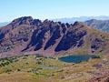
Distance: 3.4 - 13.0 miles (Round Trip)
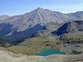
Imposing peaks, pretty waterfalls, stunning lakes, a huge alpine basin and panoramic views of the Maroon Bells, Pyramid Peak and Treasure Mountain from a 12,500-ft. pass are the scenic rewards on this 13-mile (RT) hike to West Maroon Pass.
Capitol Lake (aka Capitol Creek Trail) ![]()
Distance: 12.8 miles (Round Trip)
This long hike ascends a pretty valley through aspen groves and spruce-fir forest interspersed with meadows to Capitol Lake, an alpine jewel nestled beneath the massive west face of Capital Peak (14,130-ft.).
Distance: 13.6 miles (Round Trip)
A scenic trail with a steady ascent and short class-2 scramble leads to the summit of Mount Harvard (14,420-ft.) where hikers are greeted with stunning, panoramic views of five 14,000-ft. summits in the Collegiate Peaks and the surrounding valley.
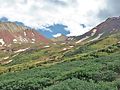
Distance: 6.4 - 10.0 miles (Round Trip)
Hike through beautiful meadows to a lovely waterfall and high alpine basin beneath Precarious and Cassi Peaks. From mid-July to early August the meadows of Rustler Gulch host spectacular wildflowers displays.
Distance: 7.4 miles (Round Trip)
This lightly used trail ascends beautiful Buckskin Basin to a stunning pass with wonderful views of Capitol Peak, Snowmass Mountain and Mount Daly.
Distance: 5.6 miles (Round Trip)
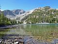
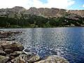
This popular hike ascends steeply up Pine Creek canyon, traveling through forests and meadows to Cathedral Lake, a gorgeous alpine gem nestled in a dramatic cirque beneath rugged granite peaks.
Distance: 8.1 miles (Loop)
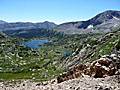
This great loop hike climbs to two scenic passes and visits a pair of gorgeous lake basins surrounded by 13,000-ft. granite peaks and ridges in the Holy Cross Wilderness.
Distance: 26.6 miles (Loop)
This popular 3-4 day backpacking loop around the stunningly beautiful Maroon Bells climbs over four 12,000-ft. passes and traverses some of the most amazing scenery in the Maroon Bells / Snowmass Wilderness area.
Distance: 6.6 - 12.0 miles (Round Trip)
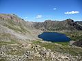
The hike to Lake Ann, cradled in a pretty alpine basin beneath the Continental Divide, features great views of Huron Peak and the Three Apostles. Continue the hike to a saddle on the divide with stunning views of the Taylor Valley and the peaks riming the Clear Creek valley.
Distance: 4.6 - 8.8 miles (One Way)
This hike traverses two scenic valleys with pretty lakes separated by a panoramic pass. From the pass wonderful views extend to the peaks and ridges along Continental Divide, the Hunter-Fryingpan Wilderness and the Collegiate Peaks Wilderness.
Distance: 11.0 miles (Round Trip)
Great views of three Colorado 14ers; Mt. Harvard, Mt. Columbia and Mt. Yale, are the rewards of this hike up the scenic Horn Fork basin to Bear Lake, an alpine jewel nestled in a rugged bowl beneath the Continental Divide in the Collegiate Peaks Wilderness.
Distance: 4.9 miles (Round Trip)
Panoramic views accompany every step of this great, easy hike along an old mining road to Yule Pass, where sweeping views extend to the peaks rising beyond Yule Creek, Purple Canyon and the Upper Slater River Valleys. Nearer at hand Purple and Treasure Mountains tower overhead.
Distance: 13.2 miles (Round Trip)
This hike ascends the beautiful Oh Be Joyful valley through wildflower-filled meadows to pretty Blue Lake cradled beneath Purple Mountain and Afley Peak. Along the way views unfold to the panorama of 12,000-ft. peaks ringing the head of the valley.
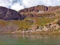
Judd Falls, Copper Lake and East Maroon Pass ![]()
Distance: 2.1 - 12.9 miles (Round Trip)
Judd Falls, Copper Lake and East Maroon Pass are all great destinations along the Copper Creek trail. The trail ascends to pretty Judd Falls and then heads up the Copper Valley to beautiful Copper Lake. Beyond the lake the path climbs to East Maroon Pass with fine views the peaks rising above the Copper and East Maroon Valleys.
Distance: 4.2 miles (Round Trip)
This trail, our personal favorite, has waterfalls, wildflowers, a pristine lake and gigantic views of the Lead King Basin and backside of the Maroon Bells. Additionally, you can and should combine this trip with 4WD or ATV circumnavigation of the Lead King Basin road with stops in Crystal City and the Crystal Mill.
Distance: 5.8 miles (Round Trip)
This is one of the most scenic hikes in the Hunter-Fryingpan area. Starting at 10,730-ft., the trail climbs on moderate grades through acres of meadows awash in wildflowers to two beautiful lakes.
Distance: 7.8 miles (Round Trip)
Great views of the Collegiate Peaks and the Elk Mountains beyond, solitude and a good workout are your rewards for hiking this lightly used trail to a pass high in the Williams Mountains.
Distance: 7.1 miles (Round Trip)
A great little hike to a beautiful lakes basin and scenic pass in the Holy Cross Wilderness.
Distance: 8.1 miles (Round Trip)
This trail travels up a beautiful, secluded valley to wind swept tarn and then a saddle on the Continental Divide overlooking the Fryingpan Lakes. The quiet valley offers good opportunities to spot wildlife and features fine views of the surrounding high peaks.
Distance: 6.2 - 6.8 miles (Round Trip)
This family-friendly scenic hike climbs on moderate grades to a lovely lake with terrific views of Mount Yale (14,196-ft.) and Turner Peak to the north, the Gladstone Ridge to the east and Jones Mountains to the West.
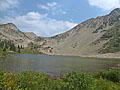
West Maroon Pass from Crested Butte ![]()
Distance: 7.8 miles (Round Trip)
Starting in Schofield Park near Crested Butte, this lovely hike ascends through the wildflower-filled meadows of the East Fork Valley to West Maroon Pass. From the pass enjoy grand views of the Maroon Bells, Pyramid Peak and Treasure Mountain massifs.
Distance: 4.6 - 11.2 miles (Round Trip)
A pretty lake along with terrific views of the Continental Divide and Mt. Massive are a few of the scenic delights along this beautiful trail paralleling the eastern flanks of the Continental Divide west of Leadville.
Distance: 9.6 miles (Loop)
This great loop hike travels up wildflower-filled meadows to two scenic passes with stunning views of the high peaks of the Elk Mountains including the Maroon Bells, Snowmass Mountain and Hagerman Peak. Route finding and off-trail travel is required to complete the loop.
Distance: 9.0 miles (Round Trip)
The strenuous hike to Elkhead Pass, one of the highest passes in Colorado, steeply ascends scenic Missouri Gulch to a 13,220-ft. pass with panoramic views of the 13,000-ft and 14,000-ft. peaks looming above the expansive meadows of Missouri Basin.
Distance: 2.5 - 6.8 miles (Round Trip)
The Anthracite Pass trail features excellent views of Treasure Mountain and Marble Peak with Mount Daly in the distance. The trail is a nice 3.5-4.5 hour hike that can be hiked from late June to October (snow dependent).
Distance: 5.8 - 12.0 miles (Round Trip)
Pretty streams, an amazing waterfall and a lovely lake set amid a beautiful basin are some of the scenic rewards of the hike to Brown’s Lake in the San Isabel National Forest.
Distance: 9.4 - 12.2 miles (Round Trip)
This lightly traveled trail features great views of the Maroon Bells and Pyramid Peak, traverses pretty meadows and ends at a scenic pass with sweeping views of the colorful cirque surrounding the Willow Lake basin.
Distance: 8.2 miles (Round Trip)
This nice hike travels to two pretty lakes cradled beneath the twin-summits of Mt. Sopris. Beyond the lakes the trail climbs steeply to the eastern summit of Mt. Sopris.
Distance: 2.2 miles (Round Trip)
This short, strenuous hike visits picturesque Windsor Lake, an alpine jewel cradled beneath the peaks and ridges along the Continental Divide in the Mount Massive Wilderness Area.

Distance: 4.7 - 9.4 miles (Round Trip)
This short hike features fine views of the Ruby Range, the Raggeds and East Beckwith Mountain. Extend the hike by walking to a high point with panoramic vistas of the West Elk Wilderness or continue to Beckwith Bench where the Anthracite Range joins the scene.
Distance: 14.0 - 17.2 miles (Round Trip)
A long sustained climb gaining over 4,300-ft. in 7.0 miles leads to a scenic pass with fine views of the Willow Lake Basin and beyond. The upper section of the trail passes through huge meadows rimmed by red-cliffs and multi-hued peaks.
Distance: 8.2 miles (Round Trip)
This nice hike climbs to a 12,290-ft. saddle on the divide separating the Bowman Creek and New York Creek valleys. At the divide enjoy great views of American Flag and Italian Mountains and nearby peaks in the Collegiate Peaks and Hunter-Fryingpan Wilderness areas.
Distance: 6.0 - 7.0 miles (Round Trip)
This hike follows the railroad bed of the first standard gauge line to cross the Continental Divide and ends at the Hagerman Tunnel (11,528-ft.), the highest railroad tunnel in the world at the time it was built in 1887.
Distance: 12.4 miles (Round Trip)
Solitude, a good workout and nice views, along with a chance to see wildlife, are the rewards for hikers of this lightly used trail ascending steeply to the saddle separating the Snowmass and Capitol Creek Valleys.
Distance: 9.4 miles (Loop)
This great loop hike starts by ascending the pretty Raspberry Creek Valley to Marble Peak (11,314-ft.). The trail then descends to Anthracite Pass and returns via the Raspberry Creek/Anthracite Pass trail. From the peak enjoy panoramic views of Snowmass Mountain, Capital Peak, Treasure Mountain and beyond.

Distance: 4.7 miles (Round Trip)
This easy hike traversing the south shore of Twin Lakes leads to Interlaken, an interesting historic site once home to a popular luxury resort during the late 1800’s. From the resort and trail along the lake enjoy fine views of Twin Lakes, Mt. Elbert (14,433-ft.) and the surrounding peaks.
Distance: 4.3 miles (Round Trip)
A short, easy hike through meadows awash with wildflowers along the west side of the East River valley offers fine views of Teocalli Mountain, White Mountain and the unnamed summits rising to the northeast of the East River.
Distance: 5.4 miles (Round Trip)
This lightly used trail ascends a ridge with nice views of Mount Daly and Capitol Peak then climbs through pretty alpine meadows to Hell Roaring Divide, where views encompass the peaks and ridges of the Avalanche Creek drainage and beyond.
Distance: 6.4 miles (Round Trip)
This short trail climbs steeply through aspen groves, forests and meadows to a high mountain lake just below the timberline, offering hikers a good workout and a great way to acclimate for some of the Aspen area’s more challenging trails.
Distance: 7.7 - 8.0 miles (Round Trip)
The lightly used trail to Josephine Lake wanders through forest, passes two large parks and then travels along a ridge with fine, albeit distant, views of the Elk Mountain Range and nearby 12,000-ft. peaks.
View Hikes by Area:
AspenBuena VistaCrested ButteLeadvilleMarble
| Support our Site |

The Region, the Hikes & the Base Camps
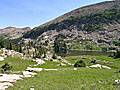
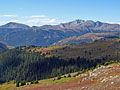
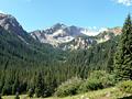
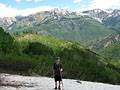
The Sawatch and Elk Mountain ranges around Aspen, Leadville, Buena Vista, Crested Butte and Marble, offer the quintessential Rocky Mountain hiking experience with glacial valleys leading to vast alpine expanses sprinkled with glistening lakes amid soaring peaks. Three national forests and six wilderness areas protect this amazing landscape. Over 200 peaks rise above 13,000-ft. with 20 of the summits topping 14,000-ft.
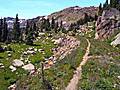
Trails galore interlace the high country of the Sawatch and Elks ranges. This hiking guide highlights the area’s best trails, the trails that take you above timberline to beautiful mountain lakes nestled in dramatic cirques, to passes with see forever views and to glorious alpine meadows filled with wildflowers. The trails, best hiked between mid-July and mid-September, range in length from 2 to 26 miles and gain between 900-ft. to 3,600-ft. in elevation. Many of the trails offer great intermediate turnaround points for those seeking shorter hikes. All are reached in less than an hour drive from five great base camps; Aspen, Leadville, Buena Vista, Crested Butte and Marble.
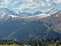
The base camps, each with its own distinct character, are linked by scenic drives traversing beautiful river valleys and crossing the high passes.
- Aspen to Leadville: The Top of the Rockies Byway between Aspen and Leadville, follows the narrow and winding CO-82 southeast through breathtaking scenery over 12,096-ft. Independence Pass to Twin Lakes, where it turns left (north) onto US-24 to Leadville. Along the way the route passing two of Colorado’s tallest peaks, Mt Elbert (14,433-ft.) and Mt. Massive (14,421-ft.). Total Distance: 58.5 miles.
- Leadville to Buena Vista: To reach Buena Vista from Leadville, follow US-24 south for 34.5 miles on the Top of the Rockies Byway and Collegiate Peaks Byway. The scenic drive along the Collegiate Peaks Byway features wonderful views of the 14,000-ft. peaks of the Collegiate Peaks Wilderness rising above the valley floor to the west. Total Distance: 34-miles.
- Aspen to Marble and Crested Butte: From Aspen take CO-82 northwest through the scenic Roaring Fork Valley to Carbondale and turn left onto CO-133, which is the start of the West Elk Loop Byway. The route ascends the beautiful Crystal River Valley, passing County Road 3, the turnoff to Marble. Beyond the turnoff the route climbs over McClure Pass (8,755-ft.), travels by the Paonia Reservoir and turns left (east) on the Kebler Pass Road (aka Gunnison County Road 12). The Kebler Pass Road, a good gravel road passable by passenger cars, climbs through beautiful forest to its namesake pass at 10,007-ft. before descending to Crested Butte: Total Distance: 104-miles.
- Crested Butte to Buena Vista: From Crested Butte head south on CO-135 to Almont and turn left (east) onto CO-742 toward the Taylor Park Reservoir. Just past the Reservoir, turn right onto the Cottonwood Pass Road (CO-209 that turns into CO-306). The route climbs over Cottonwood Pass (12,126-ft.) to Buena Vista, along the way enjoying great views of Taylor Park and the Collegiate Peaks. (Part of the Cottonwood Pass Road is a good gravel road passable by passenger cars.) Total Distance: 75.5-miles.
Base Camp Information: Aspen / Buena Vista / Crested Butte / Leadville / Marble