Best Hikes in Crested Butte, Colorado
Location: Central Colorado
On CO 135, 28 miles north of Gunnison and 92 miles northeast of Montrose
By: Diane Greer
Crested Butte, renowned for it amazing wildflower displays, is a great basecamp for hikers with plenty of scenic trails in the surrounding Elk Mountains, home to the West Elk, Raggeds and Maroon Bells-Snowmass Wilderness areas. View Crested Butte Info
Introduction
Crested Butte (8,885-ft.), located 28 miles north of Gunnison, is renowned for skiing in the winter and mountain biking in the summer. What many people don’t realize is the town is also a great basecamp for hikers with plenty of scenic trails in the surrounding Elk Mountains, home to the West Elk, Raggeds and Maroon Bells-Snowmass Wilderness areas. As an added bonus, during the height of the summer the alpine meadows of the high country are awash in an amazing display of wildflowers, considered by many to be the best in the state.
Crested Butte Hiking Trails
Distance: 9.6 miles (Round Trip)
Difficulty: moderate-strenuous
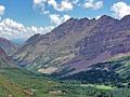
Hikers ascending the beautiful East Fork Valley to Frigid Air pass are rewarded with stunning views of the Maroon Bells, Snowmass Mountain and the nearby peaks of the Elk Mountains. In season the East Fork is famous for its spectacular displays of wildflowers.
Distance: 7.0 miles (Round Trip)
Difficulty: moderate-strenuous
Few hikers know about the gorgeous North Pole Basin. Scenic highlights include pristine meadows, cascading waterfalls, wildflowers and rugged peaks. A short off-trail stint leads to a saddle with breathtaking views of the high peaks of the Elk Mountains.
Distance: 6.4 - 10.0 miles (Round Trip)
Difficulty: moderate
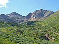
Hike through beautiful meadows to a lovely waterfall and high alpine basin beneath Precarious and Cassi Peaks. From mid-July to early August the meadows of Rustler Gulch host spectacular wildflowers displays.
Distance: 26.6 miles (Loop)
Difficulty: strenuous
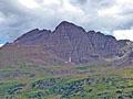
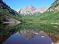
This popular 3-4 day backpacking loop around the stunningly beautiful Maroon Bells climbs over four 12,000-ft. passes and traverses some of the most amazing scenery in the Maroon Bells / Snowmass Wilderness area.
Distance: 4.9 miles (Round Trip)
Difficulty: moderate
Panoramic views accompany every step of this great, easy hike along an old mining road to Yule Pass, where sweeping views extend to the peaks rising beyond Yule Creek, Purple Canyon and the Upper Slater River Valleys. Nearer at hand Purple and Treasure Mountains tower overhead.
Distance: 13.2 miles (Round Trip)
Difficulty: moderate-strenuous
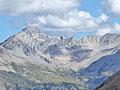
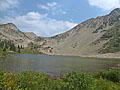
This hike ascends the beautiful Oh Be Joyful valley through wildflower-filled meadows to pretty Blue Lake cradled beneath Purple Mountain and Afley Peak. Along the way views unfold to the panorama of 12,000-ft. peaks ringing the head of the valley.
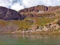
Judd Falls, Copper Lake and East Maroon Pass ![]()
Distance: 2.1 - 12.9 miles (Round Trip)
Difficulty: moderate-strenuous
Judd Falls, Copper Lake and East Maroon Pass are all great destinations along the Copper Creek trail. The trail ascends to pretty Judd Falls and then heads up the Copper Valley to beautiful Copper Lake. Beyond the lake the path climbs to East Maroon Pass with fine views the peaks rising above the Copper and East Maroon Valleys.
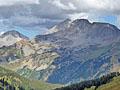
West Maroon Pass from Crested Butte ![]()
Distance: 7.8 miles (Round Trip)
Difficulty: moderate-strenuous
Starting in Schofield Park near Crested Butte, this lovely hike ascends through the wildflower-filled meadows of the East Fork Valley to West Maroon Pass. From the pass enjoy grand views of the Maroon Bells, Pyramid Peak and Treasure Mountain massifs.
Distance: 9.6 miles (Loop)
Difficulty: strenuous
This great loop hike travels up wildflower-filled meadows to two scenic passes with stunning views of the high peaks of the Elk Mountains including the Maroon Bells, Snowmass Mountain and Hagerman Peak. Route finding and off-trail travel is required to complete the loop.

Distance: 4.7 - 9.4 miles (Round Trip)
Difficulty: moderate
This short hike features fine views of the Ruby Range, the Raggeds and East Beckwith Mountain. Extend the hike by walking to a high point with panoramic vistas of the West Elk Wilderness or continue to Beckwith Bench where the Anthracite Range joins the scene.
Distance: 4.3 miles (Round Trip)
Difficulty: easy
A short, easy hike through meadows awash with wildflowers along the west side of the East River valley offers fine views of Teocalli Mountain, White Mountain and the unnamed summits rising to the northeast of the East River.
View Hikes by Area:
Central ColoradoAspenBuena VistaCrested ButteLeadvilleMarble
| Support our Site |

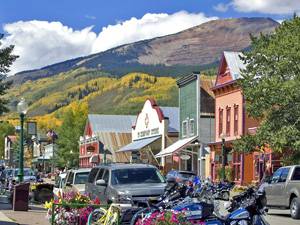
Around Town
Crested Butte got its start in the 1880’s as a supply center for nearby silver mines but soon found it was sitting atop extensive coal deposits. At the turn of the century when other Colorado mining towns were in decline, the town survived thanks to coal and coke production. Coal kept the economy going until the early 50’s when the mines started to close.
The town experienced a reversal of fortunes when a ski resort was constructed on the slopes of town’s namesake mountain, Crested Butte (12,162-ft.), in 1961. Developers moved in, building modern hotels and condos, eventually turning the area around the base of the mountain into a world class ski resort. The community centered around the resort incorporated as a separate town called Mt. Crested Butte in 1974.
That same year a large portion of the town of Crested Butte was listed on the National Register of Historic Places, leading to the preservation and restoration of the town’s Victorian-era buildings. New buildings in the district are constructed in keeping with the historic architectural style.
With the ski resort development concentrated in Mt. Crested Butte, the town of Crested Butte has retained its small town western atmosphere accented with a young, laid-back vibe. Shops, restaurants and bars now occupy the colorful Victorian buildings along Elk Ave, the town’s main drag, and the adjacent side streets. Studios of artists drawn to the town are found throughout the area.
The historic district is a great place to take a stroll and admire the Victorian architecture while browsing the town’s eclectic collection of retail establishments. Benches positioned throughout the downtown provide perches for relaxing and watching the local scene.
While strolling around town be sure to stop at the Crest Butte Visitor’s center at 601 Elk Ave (at the corner of 6th Street) to pick-up maps and other useful information. Visit the Crested Butte Mountain Heritage Museum, at 331 Elk Avenue (at the corner of 4th Street), to learn about the area’s history.
For a bird’s-eye view of the area ride the Silver Queen lift from the base area at the ski resort to the top station at 11,340-ft. From there a very steep 2.6 mile round-trip hike leads to the summit of Crested Butte (12,162-ft.). Panoramic views from the top encompass the Elk Mountains, the surrounding valleys and the town. The ski resort is reached by driving 4 miles north on 6th Street, which turns into the Gothic Road.
Diehards can walk all the way to the top of the mountain on various trails. Get a map at the ski area to see the routes, such as the Westside and Columbine trails, that ascend to the top station for the Red Lady chairlift, and then follow the road to the summit.
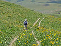
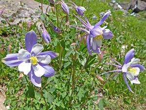
Crested Butte, dubbed the Wildflower Capitol of Colorado, is ablaze with wildflowers throughout much of the summer. Where to see the best flowers changes as the summer progresses, moving from the lower valleys near town to the high country. Some of my favorite trails for seeing wildflowers are; Beckwith Pass, Rustler Gulch, Oh Be Joyful, the East Fork valley along the Frigid Air Pass and West Maroon Pass trails, North Pole Basin and Brush Creek (described below). The timing of the wildflower displays will vary by year. Check at the visitor to center to find the best places to see wildflowers while you are visiting the area.
Wildflower enthusiasts should check out the annual Crested Butte Wildflower Festival, typically scheduled in early to mid-July. The celebration of blossoms includes tours, workshops and hikes all geared to viewing and learning about wildflowers.
Try the Brush Creek/East River trail if you are looking for an easy walk near town with great wildflowers. The 4.5 miles round-trip hike travels up the East River Valley on an old road with terrific views of the East River and White Rock Mountain. From downtown drive 2 miles south on Colorado 135 and turn left (northeast) on the Brush Creek Road/County Road 738. Follow the road to the end of the pavement, about 1.9 miles, and park at the trailhead on the left (north) side of the road.
Mountain bikers will want to head to the Evolution Bike Park at the ski area. The park offers a variety of trails for all skill levels. During the summer the Red Lady and Silver Queen lifts whisks bikers up to the top stations where several single track trails descend the mountain. Overall Crested Butte and the surrounding area offer over 700 miles of single track trails. Stop by the visitor center or one of the bike shops in town for maps and more information.
During the summer it seems as if there are more bikes than cars in Crested Butte. In addition to the Bike Park and single track trails, you will see bikers on the dirt roads that crisscross the area’s backcountry. Be considerate and share the road. Get a map at the Chamber of Commerce so you know which trails bikers frequent. To avoid bikes on the trail, stick with the trails in wilderness areas where bikes are not permitted.
Nearby Attractions
A trip to Gunnison, 27 miles south of Crested Butte on CO 135, is a good option for a rainy day. The western town features the Gunnison Pioneer Museum. The five acre property includes 16 historic buildings, a train exhibit with a depot and a Denver & Rio Grande Narrow Gauge train and an excellent collection of antique cars.
Curecanti National Recreation Area is another good rainy day option. To reach the area drive south on CO 135 for 27 miles to Gunnison and then turn left (west) on US 50 W for 9 miles to the beginning of the Blue Mesa Reservoir. Continue west on US 50 along the shore of the reservoir to the Elk Visitor Center (16 miles from Gunnison). Here you can pick-up literature on short hikes, fishing and other activities. Note: Boat tours on the reservoir need to be scheduled in advance. See the website for more information.
Continuing along Highway 50 will lead to the turnoff to the Black Canyon of the Gunnison National Park. To reach the Park from the Elk Creek Visitor Center in Curecanti, drive west on US 50 for 41.3 miles and turn right (north) on CO 347 N. Follow CO 347 north for 7.0 miles to the South Rim of the canyon.
The Kebler Pass Road is a popular scenic drive in the area, especially in the fall when the aspen are turning. The 31-mile drive over Kebler Pass (10,007-ft.) offers great views of the West Elk Mountains and the Ruby Range. In Crested Butte, head west on Elk Ave and turn left (south) on 1st Street. Follow 1st Street for two blocks and then turn right (west) on Whiterock Avenue, which turns into the Kebler Pass Road/CO 12. The road ends at Highway 133, just south of the Paonia Reservoir. At the highway, simply turn around and return to Crested Butte. I recommend combining the drive with a hike to Beckwith Pass.
Alternatively, drive over Kebler Pass and turn right (north) on CO 133 N, following the road for 26 miles to Redstone in the Crystal River Valley. The main attraction is Redstone Castle, the 42 room estate of coal and steel baron John Cleveholm Osgood. Tours include the main rooms on the first level and a few of the bedrooms on the upper floors. After the tour take a walk around the quaint little mining village and visit the antique shops, art galleries and handicraft boutiques.
Food, Lodging and Services
Crested Butte and Mt. Crested Butte offer a variety of accommodations, restaurants and retail establishments to fit a range of budgets. There are a number of small lodges, inns and B&B’s in Crested Butte. A larger selection of hotels and vacation rentals are available at the ski resort. See the Visit Crested Butte site for a complete listing of options.
If you would like to camp in the nearby Gunnison National Forest, check out the Gothic Campground located 9 miles up the Gothic Road (6th Street). There is a main campground and then a number of individual sites to the north off the Gothic Road. Sites are first come-first serve. Another nice option is the Lake Irwin Campground, reservable on recreation.gov. Drive west on the Kebler Pass Road for 5 miles and then turn right (north) on Forest Road 826. The campground is 2 miles up the road. Further afield are the National Forest campgrounds along the Taylor Canyon road.
At large camping is allowed along the Slate River Road, two to three miles up the road. Avoid areas marked as private property along the road. Car camping sites are also located along the Brush Creek Road. Check at the visitor center for more options. If you have an RV, the Crested Butte RV Resort is the only game in town if you want hook-ups.
Crested Butte offers a good selection of restaurants. Most are located along Elk Avenue and the adjacent side streets. There are also some restaurants around the ski resort, not all are open during the summer. Be sure to check. For a coffee fix I recommend Camp 4 Coffee, on 4th Street to the south of Elk Ave. For groceries visit Clark’s Market on 5th Street at Bellview Ave.