Best Hikes in Sedona
Location: Arizona's Red Rock Country
Two hours north of Phoenix, and 30 miles south of the Flagstaff.
By: Diane Greer
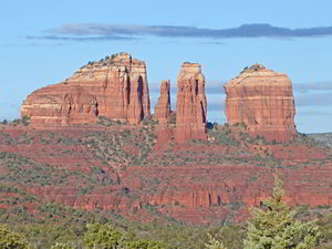
Sedona, located two hours north of Phoenix and 30 miles south of the Flagstaff, is set amid a red rock landscape of colorful mesas, buttes, spires and cliffs, some soaring more than 2,000 feet above the valley floor. View Sedona Info
Introduction
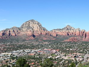
Sedona, located two hours north of Phoenix and 30 miles south of the Flagstaff, is set amid a red rock landscape of colorful mesas, buttes, spires and cliffs, some soaring more than 2,000 feet above the valley floor. A good selection of accommodations and services along with its close proximity to great hikes makes the town a perfect base camp for hikers to explore this amazing landscape.
Sedona Hiking Trails
Distance: 2.0 - 7.2 miles (Round Trip)
Difficulty: moderate
This very popular trail, one of the top hikes in Sedona, travels up the West Fork of Oak Creek Canyon along a beautiful stream surrounded by lush vegetation. Dramatic, multi-hued canyon walls soar overhead.
Brins Mesa – Soldier Pass Loop ![]()
Distance: 5.1 - 6.6 miles (Loop)
Difficulty: moderate
This great loop features terrific views of the red rock formations towering above Mormon Canyon, Soldier Pass and the upper Dry Creek Valley and visits some popular Sedona destinations including the Seven Sacred Pools, Devil’s Kitchen and the Soldier Pass Cave.
Distance: 5.1 miles (Round Trip)
Difficulty: strenuous
Nonstop views accompany this strenuous trail climbing the southern slopes of Bear Mountain. From the summit enjoys vistas of the red rock formations, deep canyons and peaks rising to the south and west along with the San Francisco Peaks to the north.
Distance: 7.4 - 10.3 miles (Round Trip)
Difficulty: strenuous
Hike to the highest mountain in the Sedona with two scenic overlooks. The south overlook features stunning views of Sedona’s red rock formations. From the north overlook superb vistas include Oak Creek Canyon, Lost Wilson Mountain, the Upper Dry Creek Valley and the Mogollon Rim.
Distance: 7.2 - 8.4 miles (Round Trip)
Difficulty: easy-moderate
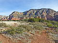
Walk as far as you like along this beautiful trail that gently ascends forested Long Canyon with intermittent views of canyon’s red rock formations, sandstone cliffs and rugged summits. Solitude, silence, an interesting habitat and opportunities for exploration add to the allure of this hike.
Distance: 3.8 - 4.2 miles (Round Trip)
Difficulty: easy-moderate
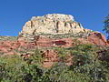
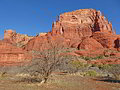
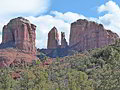
This hike offers nonstop, panoramic views of some of the best red rock formations to the south of Sedona including Cathedral Rock, Courthouse Butte, Twin Buttes, the Madonna, Child and Two Nuns spires, Gibralter Rock, Submarine Rock, Munds Mountain and Lee Mountain.
Distance: 4.4 - 6.7 miles (Round Trip)
Difficulty: moderate
This popular trail visits the Devils Kitchen, the Seven Sacred Pools and Soldier Pass Cave before climbing to the head of the Soldier Pass Canyon and Brins Mesa. From the mesa views stretch east to Wilson Mountain and north to the formations towering above the upper Dry Creek Valley.
Distance: 6.9 - 7.4 miles (Round Trip)
Difficulty: moderate
This popular hike ascends beautiful Boynton Canyon accompanied by great views of the red rock walls lining the canyon. The hike ends near the head of a dramatic box canyon beneath the east side of Bear Mountain. Side trips include a visit to the Boynton Vortex and the Subway Cave.
Distance: 1.1 miles (Round Trip)
Difficulty: easy
This short, popular hike visits the Boynton Vortex, set beneath the Kachina Women formation. The site, consider the most sacred vortex in the Sedona area, features terrific views of Bear Mountain and the red rock formation rising above Boynton and Fay Canyons.
Distance: 3.8 - 4.4 miles (Round Trip)
Difficulty: moderate
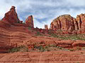
This scenic loop hike features beautiful desert scenery and stunning views of Bell Rock and Courthouse Butte along with nearby Sedona red rock landmarks including Twin Buttes, Capitol Butte, Cathedral Rock and the Seven Warriors.
Distance: 3.4 - 4.3 miles (Round Trip)
Difficulty: moderate-strenuous
Ascend Mormon Canyon to Brins Mesa and then walk across the scenic mesa to a panoramic overlook. The hike features great views of Mormon Canyon, Capitol Butte, Wilson Mountain, Angel Falls and the formations towering above Soldier Pass and the upper Dry Creek Valley.
Distance: 2.3 - 3.1 miles (Loop)
Difficulty: moderate
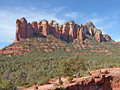
Escape the crowds on this trail that travels around an unnamed red rock butte with stunning views of the west side of Cathedral Rock. Extend the hike by taking side trips to visit beautiful Oak Creek.
Distance: 0.6 miles (Loop)
Difficulty: easy
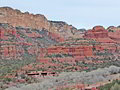
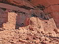
A short walk at the Honanki Heritage Site leads to interesting cliff dwellings and rock art along the base of Loy Butte. The site, occupied by the Sinagua people, is one of the largest in the area and definitely worth a visit. The road to the site is rough and requires good clearance.
Distance: 1.5 miles (Round Trip)
Difficulty: easy
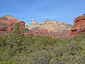
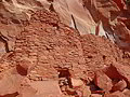
Bear Mountain towers above a beautiful canyon where alcoves and overhangs in the red rock formations protect Sinagua cliff dwellings and rock art. Three easy trails offer visitors access to the Palatki Heritage Site, reached by a rough road that requires a vehicle with good clearance.
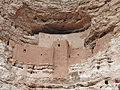
Montezuma Castle National Monument ![]()
Distance: 0.4 - 1.0 miles (Round Trip)
Difficulty: easy
A very interesting Sinagua cliff dwellings is the highlight of this small National Monument near Camp Verde, Arizona. Montezuma Wells, a detached unit of the Monument, is also worth a visit. The large sinkhole harbors Sinagua ruins and a small lake with a unique habitat and hydrology.
View Hikes by Area:
Arizona's Red Rock CountrySedona
Around Town
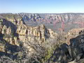
Sedona is set at the base of the Mogollon Rim, a rugged escarpment forming the southwestern edge of the Colorado Plateau. The Coconino National Forest and two State Parks are located nearby.
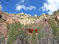
Spectacular Oak Creek Canyon, situated at the northeast end of the town, is a deep, narrow and colorful gorge carved into the edge of the Mogollon Rim. A perennial streams runs down the length of the canyon. Tails visit its tributary canyons and climb the canyon walls to panoramic overlooks.
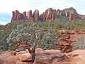
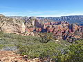
The Red Rock Secret Mountain Wilderness and the Munds Mountain Wilderness protect gorgeous areas of sculpted red rock formations, including arches, canyons and mesas to the north and east of town. An extensive network of trails travel to forested canyons, climb prominent formations and visit panoramic viewpoints.
In and around town are more trails, some of which are open to bikes. Many of the hikes connect, allowing for longer loop or point-to-point hikes.