Wilson Mountain North 
Distance: 7.4 - 10.3 miles
Red Rock Secret Mountain Wilderness, Coconino National Forest, near Sedona in Arizona's Red Rock Country
By: Diane Greer
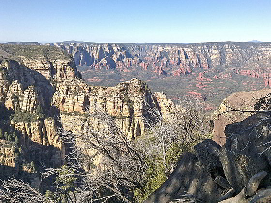
North Overlook view
Hike to the highest mountain in the Sedona with two scenic overlooks. The south overlook features stunning views of Sedona’s red rock formations. From the north overlook superb vistas include Oak Creek Canyon, Lost Wilson Mountain, the Upper Dry Creek Valley and the Mogollon Rim.
- Distance: 7.4 - 10.3 miles (RT)
- Elevation: 4,740-ft. at Trailhead
Maximum elevation - 7,040-ft. - Elevation Gain: 2,300-ft.
- Difficulty: strenuous
- Basecamp: Sedona
- Region: Arizona's Red Rock Country
Trail Description - Wilson Mountain North
The Wilson Mountain North trail starts at the north end of the Encinoso Picnic Parking area. (See driving directions below.) The trail ascends north on easy grades, briefly paralleling the highway. Along the way pass a metal sign indicating that you are on “Trail 123, North Wilson”. Soon the path turns to the left (northwest), traveling through brush and the remnants of fir and pine trees scorched in a 2006 wildfire.
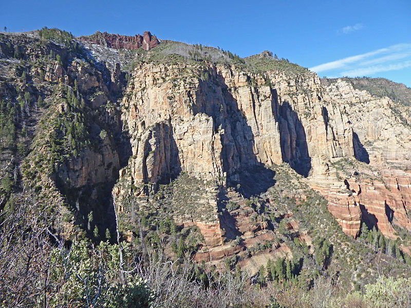
After 0.25 miles the path swings to the left (south/southwest) and ascends on moderate to moderately-steep grades, passing a sign marking the border of the Red Rock Secret Mountain Wilderness. Ahead views open to the cliffs along Wilson Mountain’s eastern flanks.
The path now climbs a drainage toward the sheer cliffs, staying to the left of a creek. After 0.7 miles the drainage splits. Our trail curves into the left fork of the drainage, which constricts. We are now ascending beneath the towering cliffs. Soon the path enters a cluster of trees that survived the fire. At 1.0 mile the path turns left (east) and climbs switchbacks up the steep slopes of a ridge between the drainage and Oak Creek Canyon. As you climb enjoy great views of the cliffs soaring above the west side of the drainage.
At 1.5 miles the grade abates a bit as the trail curves to the right (south) and climbs just below the ridge crest to a grassy plateau, the first bench of Wilson Mountain, at 1.8 miles. The path now travels across the plateau, ascending on gentle grades to a junction with the Wilson Mountain South trail at 2.25 miles. (The sign for this trail points to the Midgley Bridge Parking.)
At the junction I recommend a short detour along the Wilson Mountain South trail to the edge of the plateau for fine views of Sedona and the formation rising to the east including Mitten Ridge, Munds Mountain and Twin Buttes. (This junction is a good turn around point for parties looking for a shorter day or if the weather is taking a turn for the worse.)
Back at the junction, follow the trail ascending northwest on moderate to moderately steep switchbacks toward Wilson Mountain. The trail travels through brush and trees with views of the San Francisco Peaks and the massive plateaus of the Mogollon Rim to the east.
The trail crests the plateau atop Wilson Mountain at 2.95 miles, passing through a section of trees and then an area of partial burnt forest to a junction with the junction with the spur trail to the Sedona Overlook (South Overlook) at 3.3 miles.
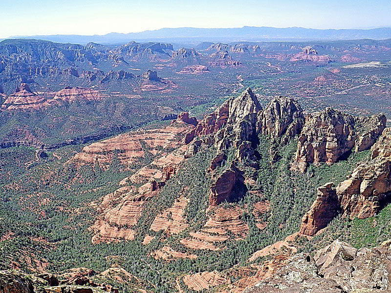
To visit the viewpoint turn left on the spur trail. The path travels over a low hill, passing through meadows and trees impacted by the fire to the overlook, set atop a cliff along the south rim of the plateau at 3.7 miles. From the overlook enjoy view of the red rock formation ringing Wilson Canyon and vistas extending south/southeast to Sedona, Cathedral rock, Twin Buttes, Mitten Ridge, Munds Mountain and beyond.
Return to the junction when you are done enjoying the views from the Sedona Overlook. This is another good turn around point, resulting in a 7.4 mile round-trip hike. Hikers looking for a long day should continue on the trail as it heads northwest across the plateau toward the North Canyon Overlook.
The path ascends through an area recovering from the wildfire, passing to the west of the summit Wilson Mountain (7,122-ft). As you travel along the trail a few patches of the older trees still stand and new vegetation is taking hold.
At 4.6 miles the trees give way to a grassy expanse scattered with new brush, reaching a high point along this section of the plateau at 4.8 miles. The path now descends on easy grades, passing through a patch of unburned trees followed by another grassy area before reaching the north end of the plateau. Here a brief climb leads to overlook atop the north rim at 5.6 miles. Older trees that escaped the fire partially obscure the view.
Take some time to wander around the rim where various opening yield stunning views. To the north are find views of the orange and white cliffs lining Oak Creek Canyon along with the formation around the Sterling Pass area. In the distance are the San Francisco Peaks. With a zoom lens or binoculars you should also be able to see Vultee Arch to the northwest of Sterling Pass. To the east is the Mogollon Rim’s vast plateau. Walk to the northwest side of the rim for great views of rugged Lost Wilson Mountain and the multi-hued formation ringing the upper Dry Creek Valley.
When you are done taking in the views, retrace your steps to the trailhead in 4.7 miles (without the 0.8 mile side trip to the Sedona Overlook) for a 10.3 mile round trip hike.
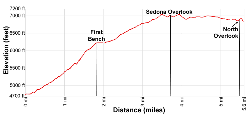
Elevation Profile
Driving Directions
Driving Directions from Sedona: From the traffic circle at the intersection of State Routes 89A and 179 head north on Arizona 89A for 5.3 miles and then turn left into the Encinoso Picnic Area and Wilson Mountain North trailhead. The trail starts on the north end of the picnic area just beyond two parking spaces.
Trail Resources
- Trail Photo Gallery
- Trail Maps
- Basecamp(s) Information: Sedona
- Region Information: Arizona's Red Rock Country
- Other Hiking Regions in: Arizona