Brins Mesa Overlook 
Distance: 3.4 - 4.3 miles
Red Rock Secret Mountain Wilderness Area, Coconino National Forest, near Sedona in Arizona's Red Rock Country
By: Diane Greer
Wilson Mountain and Lost Wilson Mountain
Ascend Mormon Canyon to Brins Mesa and then walk across the scenic mesa to a panoramic overlook. The hike features great views of Mormon Canyon, Capitol Butte, Wilson Mountain, Angel Falls and the formations towering above Soldier Pass and the upper Dry Creek Valley.
- Distance: 3.4 - 4.3 miles (RT)
- Elevation: 4,530-ft. at Trailhead
Maximum elevation - 5,450-ft. - Elevation Gain: 920-ft.
- Difficulty: moderate-strenuous
- Basecamp: Sedona
- Region: Arizona's Red Rock Country
Trail Description - Brins Mesa Overlook
There are two trailheads for Brins Mesa. The northern trailhead is located off Forest Road 152, a very rough dirt road requiring a high clearance, 4WD vehicle. From this trailhead is it 2.2 miles along the Brins Mesa trail to the turnoff to the overlook trail. The southern trailhead, known as the Jordan or Jim Thompson Trailhead, is off Arizona 89A and accessible by passenger vehicles. From here it is 1.4 miles along the Brins Mesa Trail to the turnoff for the overlook trail.
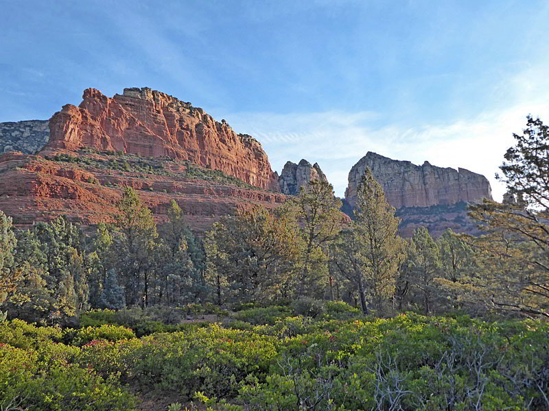
This description of the Brins Mesa Overlook hike starts at the Jordan trailhead. (See driving directions below.) The trail begins near a kiosk along the west side of the parking area. Before setting off enjoy the great views of the Fin, the Acropolis and Tisha Spire rising above the east side of Mormon Canyon.
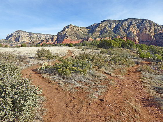
A short walk west along the path quickly leads to a trail junction. Turn right on the signed Brins Mesa Trail (#119). The trail, an old jeep road, climbs over a low rise and then ascends on easy grades through junipers, pinyons and cypress trees along the west side of Mormon Canyon. Views encompass the Cibola Mitten and Brins Butte to the west. The Fin and the rugged formation along the west facing slopes of Wilson Mountain dominate the view to the east/northeast.
After crossing a shallow drainage the trail reaches the base of the southern slopes of Brins Mesa at 1.0 mile. The path now climbs steeply up a series of red rock “stairs,” gaining almost 400-ft. Along the way enjoy ever improving views of the formation towering above Mormon Canyon.

A beautiful panorama springs into view as the trail crests Brins Mesa and quickly reaches a junction at 1.4 miles. Rugged formations rise above the mesa to the west while Wilson Mountain and Lost Wilson Mountain dominate the view to the north/northeast. Straight ahead are distant views of the multi-hued formations towering above the upper Dry Creek Valley. To the east the rugged walls rimming Mormon Canyon command our attention.
At the junction the unmarked trail to Brins Mesa Overlook branches right (east/northeast). Turn right and follow the boot beaten path as it ascends on easy grades through grasses, brush and junipers. (The top of the mesa is still recovering from a June 2006 wildfire.)
At 1.7 miles reach a “Y” intersection. The short spur trail to the right leads to an overlook above the south rim of the mesa with fine views south to Table Top Mountain, Twin Buttes, Lee Mountain and Munds Mountain. This is an optional turnaround point for parties that do not want to climb all the way to the overlook.
Beyond this point the trail now ascends on easy to moderate grades along the southeast side of the mesa accompanied by ever evolving vistas of Wilson Mountain. Soon views open straight ahead to an overlook situated atop a red rock knoll.
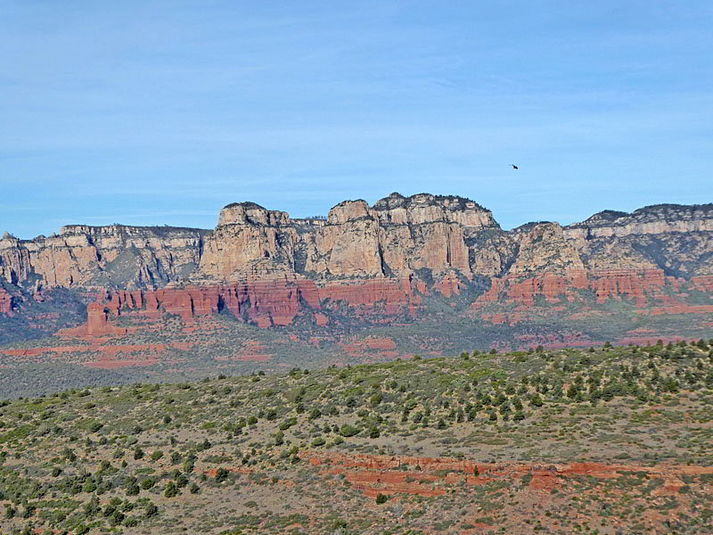
At 2.1 miles start the ascent up to the overlook. A minor amount of scrambling is required to reach the top the knoll at 2.15 miles. The overlook enjoys panoramic views stretching from Capitol Butte, rising above Soldier Mesa to the southwest, to the multihued formation towering above upper Dry Creek Valley to the northwest. To the south views stretch down the length of Mormon Canyon to Twin Buttes and Bell Rock. During the early spring or after it rains you may be lucky enough to see Angel Falls plunging down a pour-off along the western slopes of Wilson Mountain.
When you are done enjoying the views retrace your steps to the trailhead. Alternatively, return to the junction with the Brins Mesa Trail, turn right and descend gently across the plateau on the continuation of the Brins Mesa Trail to the junction with the Soldier Trail at 3.6 miles. From here, either turn around or follow the Soldier Pass Trail south to the Jordan trail. Take the Jordan and then the Cibola Trail east to the Jordan Trailhead and your vehicle. See the Brins Mesa – Soldier Pass Loop for more information.
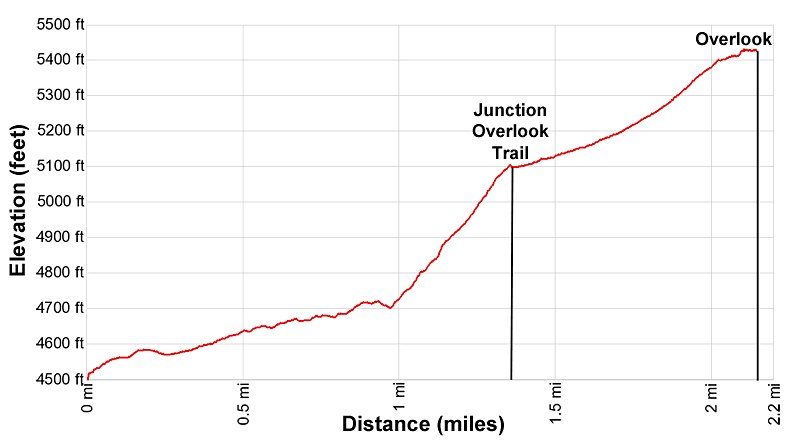
Elevation Profile
Driving Directions
Driving Directions from Sedona: From the traffic circle at the intersection of Arizona 89A and 179 head north on Arizona 89A for 0.3 miles to a traffic circle. At the circle, take the third exit onto the Jordan Road. Follow the Jordan Road for 0.8 miles and then turn left onto West Park Ridge Drive. Drive 0.7 miles to the Jordan / Jim Thompson Trailhead at the end of the road. The road will be paved for the first 0.2 miles to a cul-de-sac. Drive through the cul-de-sac and then continue on a good dirt road to the trailhead. This lot does fill so get an early start.
Note: a Red Rock Pass, America the Beautiful Interagency Pass, Golden Age Pass or Golden Access Pass is required to park in the lot. Red Rock Daily passes are $5, weekly passes are $15 and annual passes are $20. There is a machine at the parking area to purchase the pass. The passes can also be purchased in many shops around Sedona or online.
Trail Resources
- Trail Photo Gallery
- Trail Maps
- Basecamp(s) Information: Sedona
- Region Information: Arizona's Red Rock Country
- Other Hiking Regions in: Arizona