Details: North Molar Pass 
Distance: 14.4 miles (round trip)
Banff National Park, near Banff in The Canadian Rockies
By: Diane Greer
Hike Facts
- Distance: 14.4 miles (round trip)
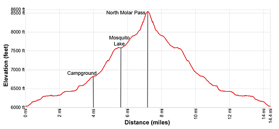
- Elevation: 6,025-ft. - 8,497-ft.
- Elevation Gain: 2,472-ft.
- Difficulty: strenuous
- Trail Highlights: See Trail Intro
- Basecamp(s): Banff / Lake Louise
- Region: The Canadian Rockies
This scenic hike travels up beautiful Mosquito creek, ascends sprawling alpine meadows filled with wildflower and then climbs rocky slope to North Molar Pass where terrific views extend to the Bow Valley, Dolomite Peak massif, the Fish Lake valley and beyond.
Trailhead to North Molar Pass
The North Molar Pass trailhead is located along the east side of the Icefield Parkway, just north of the Mosquito Creek Bridge and across from the Mosquito Creek Campground. (see Driving Directions below.) The trail initially heads north, climbing steeply and then mellows into a pleasant trail ascending through trees on easy grades to the west of Mosquito Creek.
At 1.4 miles the trail drops down to and travels along the west side of the creek through open forest. Ahead views open to the end of the ridge extending from Watermelon S2 (10,104-ft.) to the northwest. Soon the creek and the trail begin curving to the northeast, revealing views of Mosquito Mountain (9,701-ft.) and Ramp Peak (9,399-ft.) rising above the head of the valley. Noseeum Peak (9,799-ft.) towers above the east side of the valley. Dolomite Peak (9,127-ft.), unseen at this point, rises to the west.
At 2.0 miles the trees thin as the trail crosses an avalanche chute. A braided streams tumbles down the chute, carrying snowmelt from the cirque formed by Dolomite Peak and Watermelon S2 high above the west side of the valley floor. Two logs span the main stream channel, enabling you to keep your feet dry. The open slopes offer more expansive views of the head of the valley with Quartzite Mountain (9,399-ft.) now visible, rising to the north of Ramp Peak.
At 2.5 miles Mosquito Creek splits. Cross the north branch on logs. This branch curves to the northwest and drains the south faces slopes of the Watermelon Peak (10,150-ft.). Beyond the bridge we continue along the northeast branch, which starts curving to the east.
At 3.0 miles the trail crosses to the south side of the creek on a log bridge. Soon the creek and the trail swing to the southeast. The grade steepens as the trail travels beneath the rugged cliffs of Noseeum Peak, rising to the south.
Reach the Mosquito Creek Backcountry Campground, nestled in the trees by a stream, at 4.0 mile. Cross the stream on a log bridge and then follow the trail as it veers away from Mosquito Creek, heading southeast through open forest which gives way to meadows with dramatic views of Nosseum Peak and Andromache N4 (9,799-ft.) soaring overhead.
At 4.4 miles the trail splits at a signed junction. The trail branching right leads to Molar Pass (labeled as South Molar Pass on the sign). We turn left on the trail leading to North Molar Pass, Fish Lake and the Pipestone River.
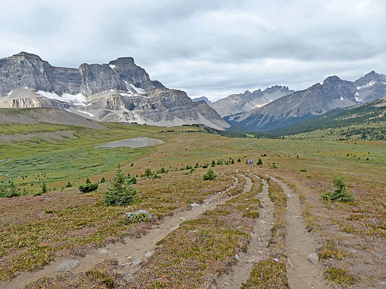
Ascend through open forest and meadows on moderate grades. At 4.8 miles the trail curves to the north and then northeast as it climbs a wooded hillside, emerging onto beautiful sprawling meadows encircled by a massive amphitheater of rugged summits at 5.0 miles. The trail through the trees is rocky and braided, but turns back into a good trail when you hit the meadows. The trail through the meadows can be boggy, depending on the time of year.
Enjoy ever improving views as you ascend through the gorgeous meadows. To the west/northwest the serrated ridge leading to the summit of Dolomite Peak and the jagged profile of the Watermelon Peak massif fill the skyline. Behind you Noseeum and Andromache N4 dominate the view. Mosquito Mountain towers above the ridge at the head of the valley while a ridge extending from Molar Mountain (9,914-ft.) rims the valley to the southeast. Mount Hector (11,135-ft.) and Mount Andromache (9,950-ft.) rise above the ridge to the south. At your feet, a vibrant profusion of wildflowers grow amid the grass.
At 5.6 miles reach the northwest end of Mosquito Lake. Hop across the lake’s outlet stream. The trail now travels above the lake’s north shore as it ascends a bench. Atop the bench the path curves to the right (east) at 5.8 miles, climbing through rocky meadows toward the pass.
At 6.6 miles the rocky meadows give way to talus slopes as the trail starts the steep ascent to the pass. The great views to the west and northwest will help take your mind off the stiff climb.
The Fish Lakes Valley springs into view as you crest North Molar Pass (8,497-ft.) at 7.2 miles. A massive wall of rock, the ridge extending north/northwest from Molar Mountain (9,914-ft.), towers above the west side of the valley. The horn rising to the south above the ridge is the summit of Molar Mountain. A stream trickles down the meadows along the valley floor. On the south side of the pass a steep trail zig-zags down the talus slopes.
To the west, the view encompasses Nosseum, Dolomite and Watermelon Peaks. Beyond rise the summits in the Bow Valley including Observation Peak (10,413-ft.), Cirque Peak (9,819-ft.) and Mount Thompson (10,134-ft.), to name a few. Mosquito Mountain dominates the view to the northeast, towering above the vast meadows we crossed to reach the pass.
The pass, just a notch in the ridge, is one of the highest places in Banff National Park accessible from a trail. When you are done taking in the scene, retrace your steps to the trailhead.
The North Molar Pass trail is the first leg of a backpack to the Fish Lakes and Pipestone Valley. Backpackers continue over the pass to highly scenic campsites at Fish Lakes. From Fish Lakes, parties ascend the Pipestone Valley, cross Pipestone pass and then explore the Devon Lakes. This is best done as a four to five day backpack. Note: Overnight permits are required to hike in Banff National Park. Advanced reservations are recommended due to high demand.
Elevation Profile
Driving Directions
From Lake Louise, AB, Canada: Head north on the Trans-Canada Highway AB-1 N for 1.5 miles and then take the Icefields Parkway (AB-93 N) exit toward Jasper and Rocky Mountain House. Follow AB-93 N for 14.7 miles and turn left into the Mosquito Creek Youth Hostel access road. Park in the lot along the access road just below the highway. Don’t block the road to the youth hostel.
The trailhead is located across the highway (east side), to the north of the Mosquito Creek bridge. Carefully cross the highway and then the bridge. You will find a brown and yellow trailhead sign on the north side of the bridge. Climb over the guard rail and follow the path to the trailhead kiosk.
From Banff, AB Canada: Head north on the Trans-Canada Highway AB-1 N for 36 miles and then take the Icefields Parkway (AB-93 N) exit toward Jasper and Rocky Mountain House. Follow AB-93 N for 14.7 miles and turn left into the Mosquito Creek Youth Hostel access road. Park in the lot along the access road just below the highway. Don’t block the road to the youth hostel.
The trailhead is located across the highway (east side), to the north of the Mosquito Creek bridge. Carefully cross the highway and then the bridge. You will find a brown and yellow trailhead sign on the north side of the bridge. Climb over the guard rail and follow the path to the trailhead kiosk.
From Field, BC Canada:– Head east on the Trans-Canada Highway (BC-1 E), which turns into AB-1 E when it crosses the border into Alberta, for 14.2 miles and then take the Icefields Parkway (AB-93 N) exit toward Jasper and Rocky Mountain House
Follow AB-93 for 14.7 miles and turn left into the Mosquito Creek Youth Hostel access road. Park in the lot along the access road, just below the highway. Don’t block the road to the youth hostel.
The trailhead is located across the highway (east side), to the north of the Mosquito Creek bridge. Carefully cross the highway and then the bridge. You will find a brown and yellow trailhead sign on the north side of the bridge. Climb over the guard rail and follow the path to the trailhead kiosk.
Trail Resources
Trail Intro / Trail Photo Gallery / Trail Map
Basecamp(s) Information:
Banff / Lake Louise
Region Information:
The Canadian Rockies
Other Hiking Regions in:
Alberta / British Columbia