Ediza Lake 
Distance: 7.8 - 13.4 miles (round trip)
Ansel Adams Wilderness Area, Inyo National Forest, near Mammoth Lakes in California's Southeastern Sierra
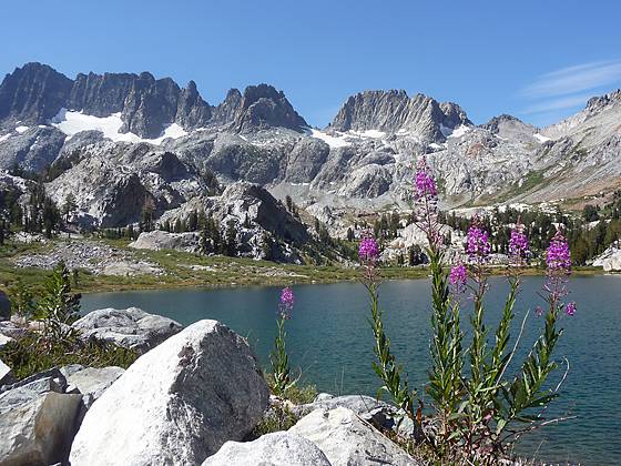
The jagged spires of the Minarets, along with Mount Ritter and Banner Peak, form the dramatic backdrop for Ediza Lake, one of the most stunning lakes in the Ritter Range. This hike visits this alpine jewel, passing beautiful Shadow Lake and a series of pretty waterfalls on Shadow Creek along the way.
See Trail Detail/Full Description
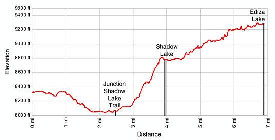
- Distance: 7.8 miles (round trip) to Shadow Lake
13.4 miles (round trip) to Ediza Lake - Elevation: 8,322-ft. at Trailhead
8,737-ft. at Shadow Lake
9,265-ft. at Ediza Lake - Elevation Gain: 697-ft. to Shadow Lake
1,225-ft. to Ediza Lake - Difficulty: strenuous
- More Hikes in:
Mammoth Lakes / Lee Vining / California's Southeastern Sierra
Why Hike Ediza Lake
Ediza is one of the most beautiful lakes in the Ritter Range. From the eastern shore of this alpine jewel views extend from jagged spires of the Minarets to the towering massifs of Mount Ritter and Banner Peak. The hike to the lake while long is quite scenic, visiting lovely Shadow Lake and wandering by the pretty waterfalls and cascades on Shadow Creek along the way. Beyond Ediza off-trail routes lead to Iceberg and Cecile Lake, tucked in deep granite bowls beneath the spires of the Minarets.
Pick a day full of promise and get an early start so you have plenty of time to lazy around the lake and admire the scenery. Be sure to check the shuttle schedule so you leave ample time to return to the trailhead before the last bus leaves the valley.
Shadow and Ediza Lakes are popular destinations so do not expect solitude on the trail or at the lakes.
Elevation Profile

Trail Resources
Trail Detail/Full Description / Trail Photo Gallery / Trail Map
Basecamp(s) Information:
Mammoth Lakes / Lee Vining
Region Information:
California's Southeastern Sierra
Other Hiking Regions in:
California
