Details: Missouri Lakes and Pass 
Distance: 7.1 miles (round trip)
Holy Cross Wilderness, White River National Forest, near Leadville in Central Colorado
By: Diane Greer
Hike Facts
- Distance: 7.1 miles (round trip)
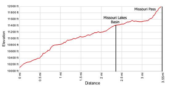
- Elevation: 10,130-ft. - 11,986-ft.
- Elevation Gain: 1,856-ft.
- Difficulty: moderate-strenuous
- Trail Highlights: See Trail Intro
- Basecamp(s): Leadville
- Region: Central Colorado
A great little hike to a beautiful lakes basin and scenic pass in the Holy Cross Wilderness.
Trailhead to Missouri Pass
From the parking area (see driving directions) follow the Missouri Lake trail through a forest of mixed conifers past water pipes and a diversion dam, which are part of the Homestake Water project, to the Holy Cross Wilderness boundary. The water project, built in the 1960’s, transfers water to the cities of Aurora and Colorado Springs.
Soon after entering the wilderness the trail crosses Missouri Creek at the mouth of a small scenic canyon. From here the moderately steep trail crosses the creek several times as it ascends alongside the creek to a large meadow. Along the way pretty cascades and small waterfalls add interest to the hike.
Beyond the meadow the grade moderates a bit as the path continues climbing though conifers, never wandering far from the creek. About 2.3 miles from the trailhead the trees give way to open meadows as you enter the Missouri Lakes basin.
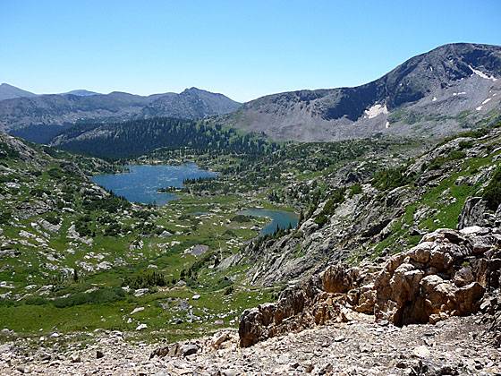
The basin, clad in rocky knobs and emerald green meadows, lies just below the timberline in an oblong cirque of granite ridges and peaks anchored to the southwest by Savage Peak (13,139-ft.). Pockets of trees scatter throughout the meadows harbor nice campsites.
For the next mile the trail ascends the basin on gentle grades, wandering by two large and three smaller lakes. A spur trail heading left (southwest), reached soon after entering the basin, leads to the sixth lake located beneath the northeast flanks of Savage Peak. Past the last lake the trail makes a short, steep ascent to Missouri pass, gaining 400-ft. in 0.4 miles.
Missouri Pass (11,986-ft.), reached after hiking 3.55 miles, enjoys expansive views of the Missouri Lakes basin. To the north the granite peaks and ridges of the Middle Mountains rimming the western side of the scenic Cross Creek valley fill the skyline. Treasure Vault Lake, an azure gem, lies nestled in pretty meadows at the head of the valley just beneath the pass.
After enjoying the view retrace your steps to the trailhead or extend the trip into a great loop hike by crossing Missouri Pass into the Cross Creek valley and then following the Fancy Pass trail to Fancy Pass, Fancy Lake and back to your car. (See the Fancy – Missouri Pass Loop hike for more information.)
Elevation Profile
Buy the BookThis opinionated guide includes all the hikes in the Aspen, Buena Vista, Crested Butte, Marble and Leadville sections of the website plus info on local services and nearby attractions. | |

Driving Directions
Driving Directions from Leadville: Travel north on Highway 24 for 19.5 miles to Homestake Road #703. Turn left and follow the road for 8.5 miles, passing the Gold Park Campground along the way. Turn right onto Homestake Road #704 and continue 3 miles on this dirt road to a "T" intersection at 10,200 ft. Turn right and the trailhead will be on the left.
Driving Directions from Vail: Travel west on I-70 to Exit #171 for Minturn, Leadville, and Hwy 24. Exit here and turn right onto Hwy 24. Proceed south for 13 miles to Homestake Road #703. Turn right and follow the road for 8.5 miles, passing the Gold Park Campground along the way. Turn right onto Homestake Road #704 and continue 3 miles on this dirt road to a T intersection at 10,200 ft. Turn right and the trailhead will be on the left.
Trail Resources
Trail Intro / Trail Photo Gallery / Trail Map
Basecamp(s) Information:
Leadville
Region Information:
Central Colorado
Other Hiking Regions in:
Colorado