Redcloud and Sunshine Peaks 
Distance: 9.0 - 11.8 miles
Gunnison BLM, near Lake City in Southwest Colorado
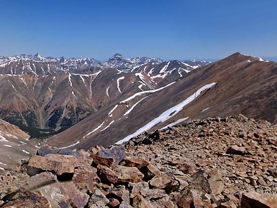
Looking north to Uncompahgre Peak from Sunshine Peak
A great hike leads to the top of two of the easiest 14ers to climb in Colorado, Redcloud (14,034 ft.) and Sunshine (14,001 ft.) peaks. From the summits a sea of peaks and ridges extend in all directions, encompassing large swaths of the San Juan Mountains.
- Distance: 9.0 - 11.8 miles (RT)
- Elevation: 10,425-ft. at Trailhead
Maximum elevation - 14,034-ft. - Elevation Gain: 3,609-ft.
- Difficulty: killer
- Basecamp: Lake City
- Region: Southwest Colorado
Trail Description - Redcloud and Sunshine Peaks
The trail to Redcloud and Sunshine peaks begins at the Silver Creek trailhead parking area (see driving directions below) and heads northeast, ascending through trees along the west side of the Silver Creek drainage. A little over a mile from the start the trail emerges from the trees and continues up the basin, paralleling the creek. Be sure to turn around during this part of the ascent for ever-improving views of Handies Peak (14,048-ft.) to the southwest.
At 2.7 miles the trail curves to the southeast and climbs to a large basin beneath the north face of Redcloud Peak at 3.1 miles. From the basin the path ascends steeply to a saddle on the ridge between Redcloud Peak and Peak 13561, gaining 650-ft. in just over 0.6 miles. Turn right and follow a very steep trail that climbs up the ridge to Redcloud Peak (14,034-ft.). On the way to the peak you will climb over a false summit. This section of the trail gains over 1,000-ft. in just 0.8 miles.
From Redcloud the path to Sunshine Peak descends from the summit along Redcloud's south ridge on an undulating trail, losing about 515-ft. to a saddle between Redcloud and Sunshine. From the saddle the rugged trail climbs 484-ft. up Sunshine's north ridge to Sunshine Peak (14,001-ft.), reaching the peak in a little over 1.4 miles.
From both summits enjoy panoramic views of a sea of peaks and ridges encompassing large swaths of the San Juan Mountains. To the north Uncompahgre Peak towers above the other summits of the Uncompahgre Wilderness. To the west is a wall of mountains extending from Ouray to Silverton. On a clear day views extend northwest to the Sneffels Range. The Needles and peaks in the Weminuche Wilderness fill the skyline to the south while to the northeast are the 12,000-ft. tundra-clad plateaus of the Powderhorn Wilderness.
Be sure to select a day full of promise and get an early start so you can take your time enjoying the wonderful views from the top and descend before the onset of afternoon thunder storms, a frequent occurrence in the Rockies.
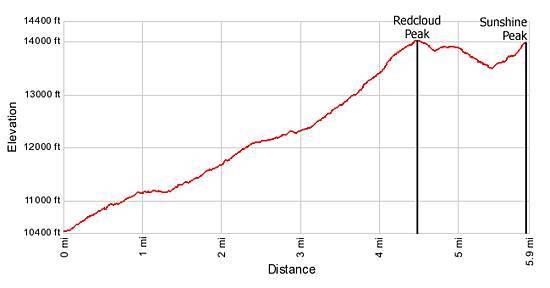
Elevation Profile
Driving Directions
Driving Directions from Lake City: From Lake City, take Highway 149 south for 2.5 miles and turn right on County Road 30 toward Lake San Cristobal. Follow the paved road approximately 4 miles, then continue on dirt road for 8.3 miles to the fork in the road. Take the right fork (the Alpine Loop Scenic Byway) and drive another 4.2 miles to the trailhead. The trail sign, located on the left, reads "Redcloud Peak." Under good conditions high clearance 2WD vehicles should be able to reach the trailhead.
Trail Resources
- Trail Photo Gallery
- Trail Maps
- Basecamp(s) Information: Lake City
- Region Information: Southwest Colorado
- Other Hiking Regions in: Colorado