Details: Beartooth Lakes Loop 
Distance: 7.8 miles (round trip)
Shoshone National Forest, near Cooke City in Beartooth Mountains
Hike Facts
- Distance: 7.8 miles (round trip)
- Elevation: 8,910-ft. - 9,920-ft.
- Elevation Gain: 1,010-ft.
- Difficulty: moderate
- Trail Highlights: See Trail Intro
- Basecamp(s): Cooke City / Red Lodge
- Region: Beartooth Mountains

This beautiful trail visits six scenic lakes, travels through meadows awash in wildflowers and features fine views of Beartooth Butte, Lonesome Mountain and the high ridges towering above the east side of the Beartooth Plateau.
Description of the Beartooth Lakes Loop

This description for the Beartooth Lakes Loop is hiked in a clockwise direction. Either direction works.
From the trailhead at the southeastern end of Beartooth Lake (see driving directions below), the level trail almost immediately splits. To the right is the Beauty Lake Trail #621, the return leg for this hike. We take trail #619, a level path that travels through wet meadows and soon crosses Beartooth Lake’s outlet stream at 0.1 miles. Early in the season you will need to remove your boots and wade across the creek. This section of the trail enjoys fine views of Beartooth Butte (10,514-ft.) towers above the western side of beautiful Beartooth Lake.
Beyond the crossing the path travels along the edge of a forest, trying to stay above the marshy meadows between the trail and the lake. At 0.3 miles the trail crosses a large meadow as it curves left (west) around the north side of the lake. Here you will need to cross several inlet streams channeling water into the lake. Early in the season this area can be very marshy.
At 0.8 miles the trail swings away from the lake and crosses to the west side of Beartooth Creek where the trail turns right (north), ascending meadows on moderate grades up the Beartooth Creek valley. Beartooth Butte towers above the trail to the west. In late July and early August the meadows are filled with gorgeous displays of wildflowers.
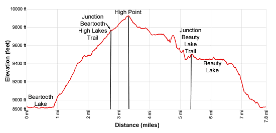
The path hops across a creek spilling down the slope of the Butte at 2.2 miles and crosses to the east side of Beartooth Creek at 2.5 miles. Trail #619 ends at a junction with trail #620, the Beartooth High Lakes Trail, at 2.7 miles. To the left the High Lakes trail heads northwest toward Native Lake. We bear right (northeast) on the Beartooth High Lakes trail toward Horseshoe Lake.
The High Lakes trail, initially marked with cairns, travels through meadows on easy grades and then rock-hops across a creek at 2.8 miles. Past the crossing the path climbs through meadows scattered with trees and rock outcroppings on moderately-easy grades, reaching the high point of the trail (9,920-ft.) atop a ridge at 3.25 miles. Here terrific views open Lonesome Mountain (11,409-ft.) and the high ridge to the east rising beyond a corrugated landscape of granite ridges and crystal blue lakes.
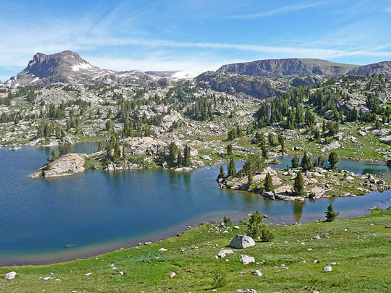
Descend through meadows to the south shore of Horseshoe Lake, adorn with a small island and a photogenic peninsula. Lonesome Mountain and the ridge form the perfect backdrop for this beautiful alpine jewel.
The trail now turns right (southeast) and descends along a chain of lovely lakes. The lakes are nestled atop benches. At the end of each bench a short descent leads to the next bench where the trail ambles along the lake shores.
The descent from the Horseshoe Lake basin leads to the bench cradling Marmot and Shallow Lakes where the trail traverses the lake’s southwestern shores. The drop to the next bench ends at the northwestern shore of Claw Lake at 4.0 miles. Here the trail crosses the north side of the lake’s inlet stream. Rocks along the stream bed should help keep your feet mostly dry. The path now curves around the head of the lake and then wanders through meadows scattered with trees and rock outcroppings to the north of the lake. Along the way pass a series of small tarns.
Cross a small stream at 4.4 miles and then follow the trail as it descends from the bench, traveling through clusters of trees and meadows to the north of a small creek. The decent is interrupted by a climb up a low ridge at 4.6 miles. Atop the ridge views open east to the ridge rimming the Beartooth Plateau to the east.
From the ridge crest the trail descends steep to moderately-steep grades through a landscape of tree-clad granite knolls and marshy meadows, passing a few tarns in route. The descent ends at 5.1 miles at the crossing of one of Beauty Lake’s inlet streams. Rocks and small grassy islands help keep your feet dry as you cross the broad, shallow creek.
Beyond the inlet stream we cross a minor stream. Soon a short climb leads to a second broad stream flowing into Beauty Lake. Again, rocks in the stream prove helpful in keeping your feet dry.
Beyond the second crossing a short, steep climb leads to a trail junction at 5.25 miles. Here we turn right (south) on the Beauty Lake Trail #621. The Beartooth High Lakes trail continues southeast toward Night and Island Lakes.
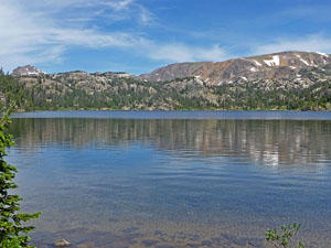
The trail now descends through trees and views open to Beauty Lake (9,430-ft.). Beartooth Butte rises in the distance to the west. At 5.5 miles the trail drops down to the shore, offering nice views down the length of the lake.
The path now heads south on easy grades along the lake’s tree-fringed eastern shore. Near the end of the lake the trail climbs over a small knoll and the curves to the right (west) around the foot of the lake.
Viewpoints along the eastern shore feature fine vistas of the peaks and ridge rising to the north of the lake and Beartooth Butte to the west. The best views, from the foot of the lake, stretch north to the 10,000-ft. to 11,000-ft. ridges and peaks to the north and east.
At 6.1 miles the trail turns left (southwest) and descends through forest on easy grades along the east side of the outlet stream. Soon the trail drops to the bench holding Crane Lake, seen through the trees.
At 6.6 miles the descent through trees steepens to moderate to moderate-steep grades. The trail breaks from the trees into meadows scattered with clusters of willows to the east of Beartooth Lake at 7.5 miles. Views open to Beartooth Butte to the west. Cross Beartooth Lake’s outlet stream at 7.6 miles and arrive back at the trailhead, completing the loop in 7.8 miles.
Elevation Profile

Driving Directions
From Cooke City, MT: Drive east on US 212 E (the Beartooth Highway) for 24.2 miles and turn left at the turnoff for Beartooth Lake. Drive through the campground for 0.6 miles, following signs to the small trailhead parking area located down a spur road on the left, just beyond the southeastern end of the lake.
From Red Lodge, MT: Drive southwest on US 212 W (the Beartooth Highway) for 41.1 miles and turn right at the turnoff for Beartooth Lake. (The turn is 1.8 miles past the Top of the World Store.) Drive through the campground for 0.6 miles, following signs to the small trailhead parking area located down a spur road on the left, just beyond the southeastern end of the lake.
Trail Resources
Trail Intro / Trail Photo Gallery / Trail Map
Basecamp(s) Information:
Cooke City / Red Lodge
Region Information:
Beartooth Mountains
Other Hiking Regions in:
Montana