Details: Unterschachen to Hoch Fulen 
Distance: 9.6 - 12.0 miles (round trip)
near Altdorf in The Bernese Oberland
Hike Facts
- Distance: 9.6 - 12.0 miles (round trip)
- Elevation: 5,305-ft. - 8,222-ft.
- Elevation Gain: 2,917-ft.
- Difficulty: strenuous
- Trail Highlights: See Trail Intro
- Basecamp(s): Altdorf
- Region: The Bernese Oberland
This long, challenging hike visits the lovely Brunnital and then ascends a wild, seldom visited valley to Hoch Fulen, a summit with stunning views of the Schachental Mountains, the Glarus Alps, including the Scharhorn, Clariden and Gross Windgallen, and the summits towering above the Reuss Valley to the west.
Unterschachen to Hoch Fulen
From the Unterschachen bus stop walk a short distance east (in the direction of Klausen Pass) and then turn right (south) on Bielenhofstrasse (Bielenhof Street) toward the Sittlisalp cable car. Yellow hiking signs at the turn indicate a 20 minute to walk to the lift. (See trailhead directions below.)
The hike passes a few houses, crosses to the west side of the river on a a bridge and then enters the Brunnital (Brunni Valley). Soon you are walking through a deep valley lined with steep cliffs. Along the way views open to the wall of mountains forming the cirque at the head of the Brunnital.
Just before reaching the cable car station signs for the Sittlisalp Talstation (valley station) direct you to turn left and cross a bridge back to the east side of the river. (Note: Bergstation refers to the upper lift station.) Beyond the bridge turn right on a spur road leading to the car park and cable car station. The total distance from the bus to the Talstation is 1.2 miles.
Take the cable car, which ascends over 1,700-ft., to Sittlisalp Bergstation at Vorder Boden (5,328-ft.). (Note: Sittlisalp is further up the valley.) The bergstation (mountain station) is situated on a broad bench along the west side of the valley. Exit the station and walk a short distance west to a trail signpost and then turn left (south) on the trail (two-track) toward Hoch Fulen.
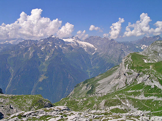
Ahead are grand views of Gross Ruchen anchoring the cirque at the head of the valley. To your right (west) the cirque formed by Sittliser, Blinzi and Gross Spitzen rims a large grassy bowl. Behind you the Schachentaler Windgallen towers above the north side of the Schachental (Schachen Valley).
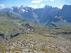
The hike ascends the valley on easy grades, passing a few alp buildings along the way. At 0.6 miles reach a junction at Sittlisalp Lauwi. Bear right to stay on the main trail heading south up the valley. At 1.25 miles reach Sittlisalp (5,413-ft.). Continue straight ahead toward Hoch Fulen.
Reach Widerflue near the head of the valley at 1.75 miles. Here a trail branches left, descending to Brunni on the valley floor. We continue along the main trail that curves to the right into the Griesstal (Griess Valley) toward Hoch Fulen. Ahead views open to Schwarz Stockli, a peak rising above the south side of the valley. Behind you are ever improving views of the Gross Ruchen and Chli Ruchen.
The trail now ascends steeply for half a mile. Ignore the trail branching right at 2.4 miles and instead continue on the main trail toward Vorder Griesstal and Hoch Fulen. At 2.5 miles the grade eases as the path travels through rocky meadows sprinkled with wildflowers. As you ascend, turnaround occasionally and look east for ever improving views of the Scharhorn. To the south the summit of the Gross Windgallen rises beyond the intervening peaks.
Reach a junction at Vorder Griesstal with a trail branching left toward Seewli at 2.9 miles. Beyond the junction the trail again climbs steeply for 0.5 miles to a small bench. As you climb the trail becomes more rugged. Be sure to turn around for fine views of Gross Ruchen and the Scharhorn to the south.
The grade briefly eases as the trail passes the ruins of a building at 3.6 miles. Soon the climb resumes on very steep grades up rock meadows that give way to scree-covered slopes and limestone outcroppings. Red and white slashes on the rocks will keep you on track.
At 4.3 miles the trail reaches the top of a ridge and a junction. Turn right (north) toward Hoch Fulen, simply listed on the sign as FULEN. The ridge enjoys amazing views stretching west across the Reuss Valley to Kronten, the Spannort massif, the Glatt Glacier and the Schloss massif. To the south are more great views of Gross Ruchen and the Scharhorn.
After a brief ascent along the ridge the trail curves left and soon reaches the ridge leading to Hoch Fulen. A final stiff climb up rocky meadows, scree and rock slabs leads to the summit of Hoch Fulen (8,222-ft.) at 4.8 miles.
Dramatic, 360-degree views encompass Clariden, the Scharhorn and Ruchen massif to the east/southeast and the Gross Windgallen to the south. The Schachental Mountains rise to the north. To the southwest a sea of peak rises along the Reuss Valley while the Spannort and Schloss massifs dominate the view to the west. Nearby peaks include the limestone summit of Balmeten (west), the Rinderstock and Rot Grat (ridge) to the south and the Schwarz Stockli and Wiss Stockli to the southeast.
After enjoying the views retrace your steps to the trailhead for a 9.6 miles round-trip hike. The walk to and from the bus stop adds 2.4 miles for a total hike of 12.0 miles. It is also possible to do a point-to-point hike, descends from the summit of Hoch Fulen to Ober Schwandi where a cable car descends to Erstfeld. From Erstfeld return to Altdorf by train. This is a very steep trail that loses over 4,570-ft. Check at the Altdorf Tourist office to determine if the Ober Schwandi lift is running and the condition of the trail before selecting this option.
Elevation Profile

Driving Directions
From Altdorf to Unterschachen and Sittlisalp Seilbahn: From Altdorf catch the #408 bus at Telldenkmal, the main square in the center of town, heading toward Klausen Pass and get off at Unterschachen Post. If starting from the Altdorf train station take a bus from the train station bound for Brugg and then change at Telldenkmal for the #408 bus heading to Klausen Pass. Check the schedule before setting out. Given the length of this hike it is best to catch an early bus. The ride to Unterschachen Post takes about 27 minutes from Telldenkmal.
From the Unterschachen Post bus stop walk east along the Klausen Pass Road to Bielenhofstrasse (Bielenhof Street) and turn right (south) into the Brunnital (Brunni Valley). Walk 1.2 miles to a large car park and the valley station for the Sittlisalp Seilbahn (cable car) .
Bus schedules are posted at the bus stops and are available online at the SBB website or the SBB app. When looking for buses use “Altdorf UR, Telldenkmal”, the UR in the name stands for the canton of Uri. See the Alp Sittlis site for the cable car timetable.
Trail Resources
Trail Intro / Trail Photo Gallery / Trail Map
Basecamp(s) Information:
Altdorf
Region Information:
The Bernese Oberland
Other Hiking Regions in:
Switzerland