Gemmi Pass 
Distance: 10.8 miles
Bernese Oberland, near Kandersteg in The Bernese Oberland
By: Diane Greer
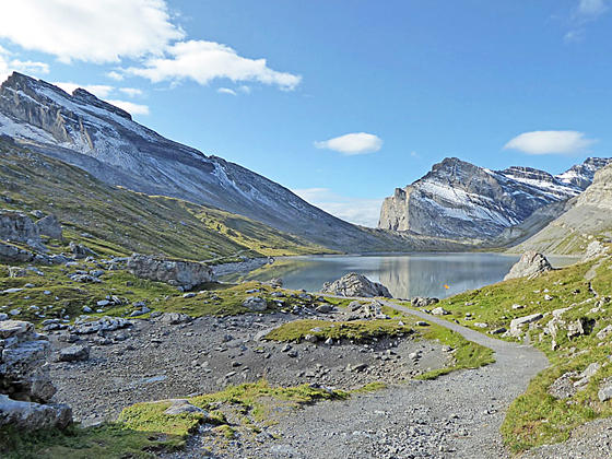
First view of the Daubensee
This trail travels up a pretty valley, rimmed by rugged cliffs and soaring peaks, passes the Daubensee, a photogenic lake, and then climbs to Gemmi Pass with panoramic views of the high peaks in the Valais, stretching from Monte Rosa to Dent Blanche and beyond.
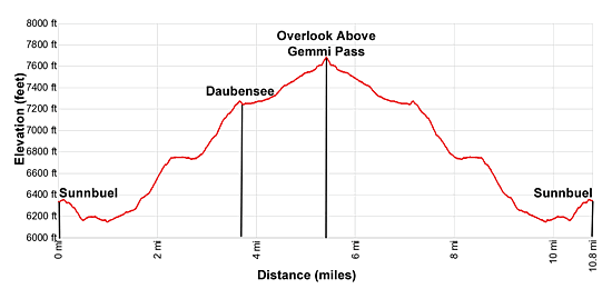
- Distance: 10.8 miles (RT)
- Elevation: 6,135-ft. at Trailhead
Maximum elevation - 7,692-ft. - Elevation Gain: 1,557-ft.
- Difficulty: moderate
- Basecamp: Kandersteg
- Region: The Bernese Oberland
Trail Description - Gemmi Pass
Gemmi Pass, situated on a saddle between the Daubenhorn and the Rinderhorn, is a centuries old crossing between the Cantons of Bern to the north and the Valais to the south. From the pass amazing, albeit distant, views encompass the high Pennine Alp in the Valais including Monte Rosa, the Matterhorn, the Weisshorn, Bishorn and Dent Blanche.
This hike, starting to the south of Kandersteg at Sunnbuel, travels through the pretty Spittelmatte Valley and then ascends to and travels along the lakeshore of the Daubensee before the final climb to Gemmi Pass. The hike is relatively easy and features fine views of the high peaks soaring about the east side of the valley and the rugged Uschenegrat Ridge rising to the west.
Start the day by riding the Kandersteg-Sunnbuel cable car to Sunnbuel. (See trailhead directions below.) At Sunnbuel find the trail signpost outside the station and walk southwest on a broad track toward Schwarenbach. The path travels through scattered trees and then descends on moderately easy grades to the Spittelmatte Valley floor.
As you descend enjoy views of Altels and the Rinderhorn towering above the valley to the east while the Uschenegrat, a high ridge, rims the valley to the west. Behind you the Doldenhorn fills the skyline above the Gasterntal Valley to the northeast. Unfortunately large electrical towers run through the valley, slightly marring an otherwise bucolic scene.
Soon we leave the trees behind and travel through pastures on easy grades, reaching a junction at the Spittelmatte alp at 1.0 mile. The broad track continues southwest toward the Schwarenbach (stream), crossing a bridge over a tributary stream and then ascending on easy grades along the west side of the stream. As you head up valley ignore any trails branch off the main track.
At 1.5 miles the grades steepens as the track ascends through a massive rockslide. The slide marks an area destroyed in September 1895 when a part of the glacier along the west facing slopes of Altels broke off and crashed down the hillside, burying part of the valley floor in ice and debris.
At 2.25 miles the grade abates and the trail now curves around a rocky slope and reaches the Hotel Schwarenbach at 2.5 miles. The hotel offers private rooms and dormitory accommodation along with a restaurant with views of the Daubenhorn and nearby peaks rising above valley. Below the hotel is a small lake.
At the west end of the hotel ignore the trail branching right toward Schwarzgratli and Engstligenalp. Instead continue along the broad track toward the Daubensee and Gemmipass. Beyond the hotel the trail curves to the left (south), crosses a bridge over a stream and then starts climbing through rocky meadows on moderate to moderately steep grades toward the Daubensee.
As you ascend enjoy views of the Uschenegrat ridge. Roter Totz and the Steghorn rise above the ridge to the southwest. The Rinderhorn soars above the valley to the east.
At 3.6 miles the climbs ends as the trail crests the bench cradling the Daubensee, the lake beneath Gemmi Pass. Soon the trail reaches the foot of the lake and a stunning viewpoint. Here the Daubenhorn and Rinderhorn rise above the pass, forming the perfect backdrop for this pretty lake. Early in the day the still waters of the lake reflect the high peaks.
A loop trail circles the lake. One leg of this loop branches right, circling around the west side of the lake. We continue on the wide track along the left (east) side of the lake that travels through meadows beside the lake shore accompanied by fine views of the Uschenegrat ridge and the high peaks towering above the pass.
At 4.3 miles ignore the trail branching right, another access point for the loop trail around the lake. Our trail now ascends on easy to moderately-easy grades to a junction just below the Pass at 5.3 miles. The path to the right leads to Gemmi Pass (7,692-ft.) at 5.4 miles and a trail dropping down to Leukerbad. The trail to the left leads to the restaurant, restrooms and the Gemmibahn, a gondola dropping down to Leukerbad, at 5.4 miles.
Overlooks around Gemmi Pass feature breathtaking panoramas of the Pennine Alps in the Valais. On a clear day you should be able to see Monte Rosa, the Matterhorn, the Weisshorn, Bishorn and Dent Blanche, just to name a few.
When you are done taking in the views, retrace your steps to the trailhead for a 10.8 mile hike. For variety, you can take the trail around the west side of the lake on the return journey, which adds 0.75 miles to the hike.
Parties looking for a short hike can ride the Gemmibahn down the Leukerbad and then catch a bus to Leuk where a series of trains return to Kandersteg. The ride back to Kandersteg takes about one hour and 40-minutes.
Elevation Profile
Driving Directions
Note: It is possible to walk from Kandersteg to Sunnbuel. The hike adds 3 hours and 2,438-ft. in elevation gain to the day. I strongly recommend taking the cable car. To Walk, hike south on the main road through Kandersteg to the Sunnbuel Cable Car Station. Continue on the road past the cable car station. Soon you will see a trail signed for Stock and Sunnbuel. Turn left and follow the trail that climbs steeply to Sunnbuel.
Kandersteg Bahnhof (Train Station) to Sunnbuel Cable Car:
Walking: From the front (east side) of the train station, walk south a short distance and turn left (east) onto Bahnhofstrasse (Train Station Street). Walk about 700-ft. east on Bahnhofstrasse, passing the Coop Supermarket along the way. When you hit the main road (Dorfstrasse) turn right. Follow the main road to the Luftseilbahn Kandersteg-Sunnbuel (Cable car – Kandersteg to Sunnbuel). The 1.6 mile walk should take about 30-40 minutes.
Bus: Take the #241 bus from the Kandersteg Bahnhof (train station) to the Talstation Luftseilbahn Sunnbuel (valley station for the Sunnbuel Cable Car). The ride should take about 9 minutes. The bus makes a number of stop along the main road through the town. Check the SBB website or download the SBB app for the current schedule and to find the stop nearest to your accommodations.
Gemmi Pass to Kandersteg: From Gemmi Pass ride the Gemmibahn cable car down to Leukerbad. From the valley station, follow signs to the Leukerbad Bahnhof (train station) where you want to take the #471 bus to the Leuk Bahnhof (train station). At the Leuk train station purchase tickets for Kandersteg. You will need to take the train to Gampel-Steg and then switch to the train bound for Goppenstein. At Goppenstein, change to the train to Kandersteg. The entire ride should take about one-hour and 40-minutes. Check the SBB website or download the SBB app for the current schedule and best connections.
Trail Resources
- Trail Photo Gallery
- Trail Maps
- Basecamp(s) Information: Kandersteg
- Region Information: The Bernese Oberland
- Other Hiking Regions in: Switzerland