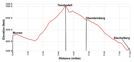
Hike Facts
- Distance: 7.7 - 8.6 miles (one way)
- Elevation: 4,480-ft. - 7,000-ft.
- Elevation Gain: 2,930-ft.
- Difficulty: strenuous
- Trail Highlights: See Trail Intro
- Basecamp(s): Lauterbrunnen
- Region: The Bernese Oberland
The best hike in Lauterbrunnen climbs steeply to Tanzbodeli, an overlook atop a grassy plateau with jaw-dropping, panoramic views of the high peaks towering above the Lauterbrunnen and Sefinen Valleys. The return via Obersteinberg is packed with visual delights.
Tanzbodeli
Distance from Trailhead: 3.5 miles (one way)
Ending/Highest Elevation: 7,000-ft.
Elevation Gain: 2,930-ft.
Take the Schilthorn Cable Car, a multi-stage lift, to the first station in Gimmelwald (4,472-ft.). (See trailhead directions below.) Exit the cable car station and walk southwest toward Busenalp and Obersteinberg on a paved path that travels through the small village of traditional wood houses and small barns. At the first intersection ignore the trail branching left toward Stechelberg, Wasserbrigg and Obersteinberg. Instead continue straight ahead toward Busenalp (2-hr), Obersteinberg (3-hr) and Tanzbodeli (2-hr 45-min).
Soon the path curves to the southwest into the Sefinental (Sefinen Valley) where beautiful views open to the Ellstabhorn, Tschingelgrat (Tschingel Ridge), Gspaltenhorn and Butlasse rising along the valley. Tanzbodeli is seen to the south, the flat plateau to the east of a small horn (the Spitzhorn) on the high ridge rising above a wooded hillside.
At 0.4 miles reach a junction at a hairpin curve. Take the gravel trail branching right off the paved path. The trail now descends west on gentle grades, traveling along the north side of the Sefinen Valley toward Busenalp, Obersteinberg and Tanzbodeli. At 0.6 miles the path crosses a bridge over a stream and then continues descending through trees.
Reach a junction and the floor of the Sefinental valley (4,134-ft.) at 1.2 miles. Ignore the trail continuing straight ahead toward the Kilchbalm, Rotstockhutte and Sefinenfurgge. Instead, follow the gravel path as it makes a sharp left on a hairpin curve toward Busenalp and Obersteinberg. Soon the path reaches a second junction where we turn right toward Tanzbodeli and Obersteinberg. A red arrow on a tree, in addition to signs, marks the turn.
The trail now drops down to and crosses a bridge over the stream draining the Sefinental. Beyond the bridge the trail heads southeast, ascending on very steep grades through forest along the south side of the Sefinental. As you gain altitude openings in the trees offer views of the Lauberhorn and Tschuggen rising along the Mannlichen ridge across the Lauterbrunnen valley to the northeast.
At 2.5 miles the trail curves south into a small valley and the trees give way to pretty meadows. Views open to Tanzbodeli and the Spitzhorn on the ridge towering above the trail to the south.
Reach a “Y” intersection at Untere Busenalp (5,814-ft.) at 2.7 miles. Ignore the trail branching right toward Busenalp. Take the trail to the left toward Tanzbodeli and Obersteinberg. The path now climbs steeply through meadows scattered with trees and low shrubs, heading toward the ridge separating the Sefinen and Lauterbrunnen Valleys. As you gain elevation enjoy great views up the Sefinental Valley to the west. The Jungfrau towers above the Lauterbrunnen Valley to the east.
Crest the ridge and reach Busengrat (6,490-ft.) at 3.1 miles. You are now standing high above the west side of the Lauterbrunnen Valley. Across the valley to the east great views extend from the Jungfrau to the Breithorn.
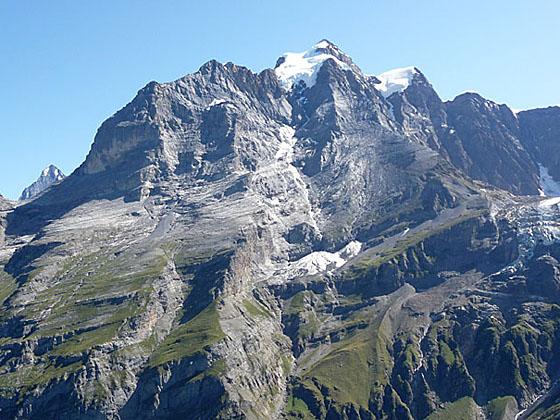
Turn right at the junction toward Tanzbodeli. The narrow trail climbs very steeply up meadows and rock ledges. At times you may feel the need to use your hands. Reach Tanzbodeli (7,000-ft.), which means the “dance floor”, at 3.5 miles. It is fun to watch people arrive at the flat grassy plateau atop the ridge. The first reaction is typically a broad smile, followed by the exclamation -- Wow!
Wow is really the best way to describe the jaw-dropping, 360-degree views from the plateau. The Jungfrau, Gletscherhorn, Abeni Flue and Mittaghorn soar above the east side of the Lauterbrunnen valley. At the head of the valley to the south, the cirque formed by the Grosshorn, Breithorn, Tschingelhorn and Ellstabhorn forms the perfect backdrop for the Schmadribachfall (waterfall) plunging down the lip of a hanging valley. To the west/northwest the peaks surrounding the Sefinental, including the Gspaltenhorn, dominate to the view while to the north views extend down the length of the Lauterbrunnen Valley. All around you glaciers, clinging to the flanks of the high peaks, glisten in the sun.
Stechelberg (Complete Hike)
Distance from Trailhead: 7.7 miles (one way)
Ending/Highest Elevation: 2,985-ft.
Elevation Gain: -4,015-ft.
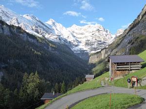
On a sunny day it is truly hard to pull yourself away from the amazing Tanzbodeli viewpoint – one of the best in the Bernese Alps. When you are ready to continue hiking, carefully retrace your steps back to the junction at Busengrat and turn south toward Obersteinberg (50-min).
After a short, easy ascent through rocky meadows, the trail curves to the southwest as it descends along the western slopes of the Lauterbrunnen Valley. Across the valley are splendid views extending from the Jungfrau to the Tschingelhorn. The rugged crags of the Ellstabhorn loom above the trail. Soon the buildings of Obersteinberg, nestled on a shelf along the hillside, come into views.
At 4.6 miles the trail curves to the east, descending through bucolic pastures to a junction at Obersteinberg (5,833-ft.) at 4.8 miles. Turn right (south) to visit the pretty alp and the viewpoints just beyond.
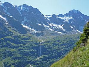
The alp includes a circa 1880 hotel, with comfy rooms and dormitory accommodations, and a small restaurant with stunning views of the peaks across the valley. Past the restaurant walk southwest along the trail toward the Oberhornsee for a short distance to a splendid viewpoint with front row seats for beautiful Schmadribachfall, dropping 1,000-ft from the lip of a hanging valley. The stunning glacial cirque ringing the head of the valley towers above the falls. Visiting the viewpoint adds 0.5 miles (round trip) to the hike.
From Obersteinberg hikers are presented with a variety of options. Parties with the time and energy can take a side trip to the Oberhornsee, a small lake, situated in the rocky meadows between the moraines of the Breithorn and Tschingelfirn glaciers.
Side Trip to the Oberhornsee
The trail to the Oberhornsee begins at the “Y” intersection to the south of the Obersteinberg Hotel. Take the trail branch right toward the Oberhorn and Oberhornsee that ascends along the right (west) side of the valley. At 1.0 mile the path crosses a bridge over the Tschingel stream carrying meltwater from the Tschingelfirn Glacier. Beyond the junction the trail climbs steeply to a bench and the Oberhornsee (6,775-ft.), a small lake, after gaining over 940-ft in 1.75 miles.
The lake enjoys spectacular views of the Breithorn, Tschingelhorn, Gspaltenhorn and the Ellstabhorn forming the cirque at the head of the valley. The Jungfrau dominates the view to the north. After enjoy the views, retrace your steps to Obersteinberg. Total round-trip distance for the side trip is 3.5 miles
Trails to Stechelberg
There are two trails from Obersteinberg to Stechelberg, the high route and the valley route. I prefer the high route which is a shorter, steeper and more scenic. The valley route, which is longer and not as steep, enjoys great views of the waterfall, wanders along the west side of the Weisse Lutschine River and passes through Trachsellauenen, the former home to lead, silver and barite mines.
The High Route to Stechelberg
To take the high route, return to the junction to the south of Obersteinberg. Head northeast on the trail toward Hotel Tschingelhorn and Stechelberg, which travels by the Hotel Obersteinberg and then descends through high meadows along the west side of the Lauterbrunnen Valley. Along the way enjoy great views of the peaks across the valley. Initially the trail descends on easy grades but soon the grade steepens.
Pass the Hotel Tschingelhorn at 5.4 miles. Beyond the hotel the trail descends on very steep grades. At 5.9 miles the trail enters the trees and loses the views. Reach a junction at 6.9 miles and take the trail heading toward Stechelberg, Gimmelwald and Murren.
At 7.1 miles reach an intersection at Schwendiwald (3,740-ft.). Turn right (northeast) toward Stechelberg on a trail that drops down a series of steep switchbacks to the valley floor. (The other trail climbs toward Gimmelwald and Murren.) Cross a bridge over the river to the east side of the valley at 7.5 miles and then follow the broad track through the village to the bus stop at the Hotel Stechelberg (2,985-ft.) at 7.7 miles.
The Valley Route to Stechelberg
To take the valley route, walk to the trail junction to the south of the Hotel Obersteinberg. Here a trail signed for Scheuerbode (45-min), Trachsellauenen (1-hr 15-min) and Stechelberg (2-hr) drops down steep switchbacks, traveling through meadows and then scattered trees. Along the way enjoy nice views of Schmadribachfall. Reach Wilde Egg at 5.6 miles, where a trail branches right (south) toward the base of the falls. Continue along the main trail toward Stechelberg, which drops to the valley floor at Schirboden, a bucolic alp set amid pretty meadows.
The trail toward Stechelberg now travels along the west side of the Weiss Lutschine River, passing through meadows and clusters of trees. Behind you are good views of the falls. The peaks along the valley tower overhead. Pass through Bergwerk at 6.7 miles, ignoring the trail that branches left and climbs steeply to the Hotel Tschingelhorn and Obersteinberg. In a short distance pass Trachsellauenen, a former mining site.
The trail now turns into a broad gravel path which soon joins a gravel alp road. Pass through Im Boden at 7.8 miles where a trail branches right toward Gimmelwald and Murren. We take the trail branching off the road toward Stechelberg (20-min). A good gravel trail drops down to and crosses a wood bridge over the river at 8.0 mile and then travels along the east side of the river. Soon the trail joins with a road through the village, reaching the bus stop at the Hotel Stechelberg (2,985-ft.) at 8.6 mile.
Elevation Profile
Driving Directions
From the Lauterbrunnen Bahnhof to Gimmelwald via the Schilthorn Cable Car system: From the bus stop near the northern end of the Lauterbrunnen Bahnhof (train station), take the #141 bus bound for Stechelberg and get off at the Schilthornbahn, the bottom station for the cable car system to the Schilthorn. The bus ride takes about 14 minutes. Note: There are many bus stops between the train station and the lift station. Check SBB website or download the SBB app for the current schedule and to determine the stop nearest to your accommodation.
At the Cable Car station, purchase a ticket for Gimmelwald. Take the cable car to Gimmelwald and exit the cable car station. Note: This is a four stage cable car which goes from bottom station to Gimmelwald and then to Murren, Birg and the Schilthorn, a popular viewpoint.
Return from Stechelberg to Lauterbrunnen: From the bus stop near the Hotel Stechelberg, catch the bus #141 bound for the Lauterbrunnen Bahnhof. Check the SBB website or download the SBB app for the current schedule.
Trail Resources
Trail Intro / Trail Photo Gallery / Trail Map
Basecamp(s) Information:
Lauterbrunnen
Region Information:
The Bernese Oberland
Other Hiking Regions in:
Switzerland