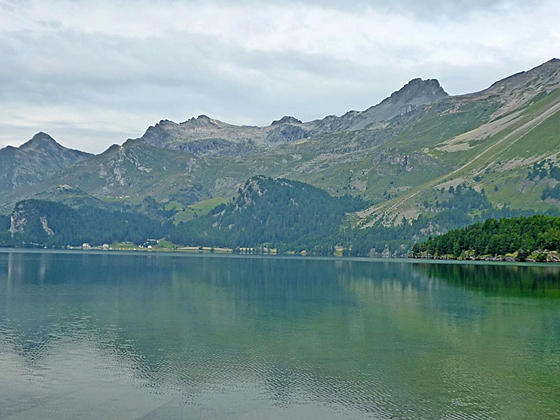
Close-up of Piz Materfell and Grevasalvas
This delightful walk traverses the eastern shores of Lake Silvaplana (Silvaplanersee) and Lake Sils (Silsersee) with lovely views stretching across the lakes to the high peaks towering above the Upper Engadine Valley.
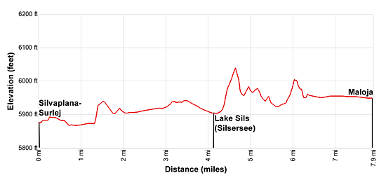
- Distance: 3.3 - 7.9 miles (One Way)
- Elevation: 5,870-ft. at Trailhead
Maximum elevation - 6,060-ft. - Elevation Gain: 190-ft.
- Difficulty: easy
- Basecamp: St Moritz
- Region: Eastern Switzerland
Trail Description - Lakes Trail: Silvaplana to Maloja
This easy hike follows a section of the Senda Segantini (Segantini Trail), passing scenes painted by Giovanni Segantini, a famous 19th century landscape artist. After your walk visit the Segantini Museum in St. Moritz to see his paintings of the shimmering Engadine lakes and rugged peaks.
Families and parties with hikers of mixed abilities will love this scenic ramble. The hike is also a good option if the weather precludes hiking in the high country.
The hike can be walked in either direction, although I prefer walking up valley. You can also shorten the day by stopping or starting the hike in Sils/Segl Maria, a village situated between the two lakes.
Note: Piz in Romansh, a language spoken by some in the Swiss Engadine, means peak and lej, leg and lai means lake. So Piz Lagrev is Lagrev Peak and Lej Segl is Lake Segl, or in German: Silsersee. On trail signs you will often see two different names (one in Romansh and one in German) or different spellings for a destination. For example Sils: German and Segl: Romansh.
Walking the Lakes Trail
Take the bus to Surlej Brucke, located on the east side of the bridge between Lej Suot (Lake Suot) and Lake Silvaplana (Silvaplanersee/ Lej da Silvaplauna). (See trailhead directions below.) Walk east (away from the bridge) a short distance to a broad track heading south. Turn right and walk along the track toward Sils/Segl Maria. The path is also signed for trail #25, the Senda Segantini (Segantini Trail).
To your right (west) pass the Castle Crap da Sass, built in 1906 by the German General Count von der Lippe. Views extend up the length of Lake Silvaplana to Piz de la Margna and Piz Lunghin rising above Maloja Pass.
The path now travels through meadows with views of the lake and high peaks from Piz Julier to Piz Lagrev towering above the northwest side of the Upper Engadine Valley. On a still day the high peaks are reflected in the lake’s mirror like surface. The village of Silvaplana-Surlej lies along the valley floor at the northeast end of the lake.
At 0.7 miles the path comes abreast of the lakeshore and enters a forest of larch trees. The undulating trail traverses along the shore, passing a waterfall spilling down the slopes above the path. Ignore any trails branching left and ascending to the Alp Sulej and Furtschellas. Instead, stay on the #25 trail to Sils/Segl Maria.
As you approach the head of the lake views open to village of Sils/Segl Maria and the high peaks, including Piz Materdell, Piz Grevasalvas and Piz Lunghin, rising to the west of the Piz Lagrev massif.
Reach the head of the Lake Silvaplana at 2.4 miles and bear left on trail #25 toward Sils/Segl Maria and the Furtschellas lift station. The trail now travels through fields, passing the station for the Furtschellas cable car at 2.8 miles. At the cable car station the trail joins a paved road.
Note: If you wish to cut the hike short you can catch buses returning to St. Moritz at the Furtschellas cable car station and the Sils/Segl Maria Post along the main street (see below).
Continue along the road, bearing left at a “Y” junction. Reach the main road (Chesa Alva or Alvetern depending on your map) through the village of Sils/Segl Maria at 3.2 miles. Turn left at the road and walk along the sidewalk through town, passing several hotels, restaurants, the post office and shops. At the south end of town turn right (northwest) on Via de Marias. (If you start climbing up a hill on a road you have gone too far, turn around and turn left onto Via de Marias.) Signs along the way will point toward trail #25, Isola and Maloja.
Walk along the road, passing the Alpenrose Restaurant on the left. Turn left (west) on the next road, Chesa Cadisch, signed for Isola and Maloja. The path now travels west/southwest through fields with great views of the high peaks rimming the northwest side of the Upper Engadine Valley. Ignore any trails branching left or right off the main trail.
At 4.1 miles reach the foot of Lake Sils (Silsersee/Lej da Segl), the largest of the Engadine lakes. Beautiful views stretch up the length of the lake to Piz Duan rising beyond Maloja Pass. The high peaks from Piz Lagrev to Piz Lunghin dominate the view across the lake to the west/northwest. The Chaste Peninsula extends into the north end of the lake while the wooded island of Chaviolas lies a short distance off the shore.
Past the foot of the lake the undulating trail starts ascending through larches above the lakeshore to a high point at 4.7 miles. Here you are above the northeast end of a large delta jutting into the lake at the foot of Val Fedoz (Fedoz Valley).
The trail now descends through trees and scattered meadows with views of the delta. Soon views open to the Aua da Fedoz, the river draining the Fedoz Valley, flowing across the delta. The rugged crags of Piz Lagrev dominate the views across the lake.
At 5.3 miles cross a bridge over the Aua da Fedoz and enter the small village of Isola, located on the delta. Follow the broad track along the southeast side of the village toward Maloja, passing a restaurant on the way.
Soon we leave the houses behind and continue through pastures to the end of the delta. Beyond the delta the broad track traverse through meadows and trees along the lakeshore.
At 6.0 miles the trail to Maloja branches right off the broad track. Alternative, continue along the broad track to Maloja. I recommend the trail, which traverses beside the lakeshore and is more scenic.
At 6.9 miles pass the entrance to a campsite and a small boat dock along the lake. Signs now point to the bus stop at Maloja Post. For the remainder of the hike we follow the signs to the bus station at the post office.
Reach the head of the lake and a junction at 7.2 miles. Bear left away from the lakeshore toward Maloja Post. (The trail to the right travels along the shore above the head of the lake.) Our path now passes houses as it heads toward the center of town.
At 7.6 miles reach a junction and turn right toward the Maloja bus stop. (The Senda Segantini branches left.) At 7.8 miles reach a “T” intersection and the main street through the town. Turn right and walk north along the road to the post office and bus stop, located on the left (west) side of the street at 7.9 miles.
Elevation Profile
Driving Directions
From St. Moritz Bahnhof (Train Station) to Surlej, Brucke: From the St. Moritz train station, take either a #1 or #6 bus heading toward Corvatschbahn (Corvatsch cable car) and get off a Surlej Brucke. This stop is located on the east side of the bridge between Lej Suot (Lake Suot) and the Silvaplanersee (Lake Silvaplana). Bus schedules are posted at the bus stops and are available online at the SBB website or on the SBB app.
From Maloja Post to St. Moritz Bahnhof (Train Station): From the post office in Maloja, board a #4 bus bound for St. Moritz Bahnhof or a #2 bus bound for Pontresina Bahnhof. If you take the #2 bus you need to change at Silvaplana, Freisel Mitte for a #1 bus to St. Moritz Bahnhof. The ride takes 30 minutes on the #4 bus or 40 minutes if you have to change using the #2 and #1 buses. Bus schedules are posted at the bus stops and are available online at the SBB website or on the SBB app.
Trail Resources
- Trail Photo Gallery
- Trail Maps
- Basecamp(s) Information: St Moritz
- Region Information: Eastern Switzerland
- Other Hiking Regions in: Switzerland