Slickhorn Canyon, Third Fork to Trail Fork 
Distance: 10.5 miles (loop)
BLM, Monticello, Utah office, near Blanding in Southeast Utah
By: Diane Greer
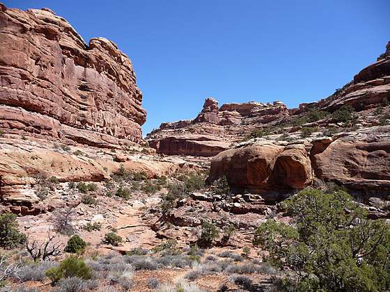
Looking up the Trail Fork of Slickhorn Canyon
This rugged loop hike explores one of the lesser visited canyon systems on Cedar Mesa, traveling down the Third Fork of Slickhorn Canyon and then ascending the Trail Fork of Slickhorn Canyon. The canyons are quite scenic, with sculpted red and white sandstone walls stained with desert varnish towering overhead. Observant hikers will spot a few ruins and rock art panels along the way.
See Trail Detail/Full Description
- Distance: 10.5 miles (loop) to Third Fork to Trail Fork
- Elevation: 6,190-ft. at Trailhead
5,130-ft. at Third Fork to Trail Fork - Elevation Gain: -960-ft. to Third Fork to Trail Fork
- Difficulty: moderate-strenuous
- More Hikes in:
Bears Ears NM / Mexican Hat / Southeast Utah
Why Hike Slickhorn Canyon, Third Fork to Trail Fork
This rugged loop hike explores one of the lesser visited canyon systems on Cedar Mesa, traveling down the Third Fork of Slickhorn Canyon and then ascending the Trail Fork of Slickhorn Canyon. The canyons are quite scenic, with sculpted red and white sandstone walls stained with desert varnish towering overhead. Observant hikers will spot a few ruins and rock art panels along the way.
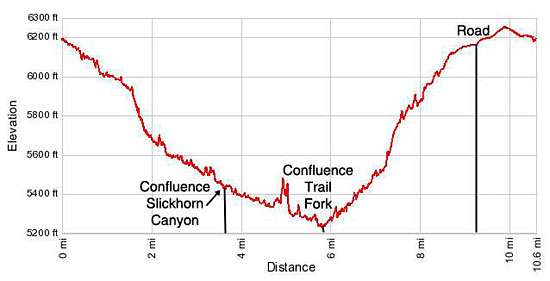
Elevation Profile
Trail Resources
Trail Detail/Full Description / Trail Photo Gallery / Trail Map
Basecamp(s) Information:
Bears Ears NM / Mexican Hat
Region Information:
Southeast Utah
Other Hiking Regions in:
Utah