Details: Paradise Valley / Giant Steps 
Distance: 7.0 - 12.6 miles (round trip)
Banff National Park, near Banff in The Canadian Rockies
Hike Facts
- Distance: 7.0 - 12.6 miles (round trip)
- Elevation: 5,650-ft. - 6,980-ft.
- Elevation Gain: 1,330-ft.
- Difficulty: moderate-strenuous
- Trail Highlights: See Trail Intro
- Basecamp(s): Banff / Lake Louise
- Region: The Canadian Rockies
The stunningly beautiful Paradise Valley has all the components of a perfect hike with glorious views of cascading streams, waterfalls, pretty meadows, a lovely lake and a magnificent cirque. Shorten the hike by visiting Lake Annette or walking to the overlook near the head of the valley.
Trailhead to Giant Steps

The Paradise Valley trailhead is located 1.5 miles along the Moraine Lake Road to the south of Lake Louise. (See driving directions below.) The broad dirt trail starts at the south end of the parking area and heads southwest, ascending through spruce-fir forest on easy to moderate grades along the north side of the valley. An opening in the trees at 0.6 miles offers the first views of ice-capped Mount Temple (11,621-ft.) to the south. A short distance beyond the trail briefly draws near Paradise Creek, seen through the trees tumbling down the valley floor.
At 0.7 miles reach a junction with the Moraine Lake Trail, a path that runs between Lake Louise and Moraine Lake. Up to this point you have been sharing the trail with bicyclists. All bikes must turn left (southwest) at the junction on the Moraine Lake Trail. We turn right (north) on the combined Paradise Valley / Moraine Lake trails. The two trails split at a second junction at 0.8 miles. Here we turn left (west) on the Paradise Valley Trail toward Lake Annette, Sentinel Pass and the Giant Steps.
The trail now ascends on easy grades through predominantly viewless forest, curving to the southwest along the way. After a mile the trail descends gently to a wood bridge crossing Paradise Creek at 2.1 miles. From the bridge Mount Temple, towering above the valley to the south, offers a fine backdrop for Paradise Creek.
On the east side of the creek the trail continues its ascent through forest. Openings in the trees offer our first glimpse of the peaks at the head of the valley. Sheol Mountain (9,107-ft.) looms overhead to the west.
Cross to the west side of Paradise Valley on a second bridge at 2.4 miles. The open area around the bridge offers unobstructed views of the north face of Mount Temple, the highest peak in the Lake Louise area. On the far side of the bridge is the junction with the trail climbing north to Sheol Valley, Saddleback Pass and Fairview Mountain (9,000-ft.). We continue on the Paradise Valley trail toward Lake Annette.
Beyond the bridge the trail ascends southwest on easy grades through trees and few small meadows to a third bridge crossing Paradise Creek at 3.2 miles. Older maps show a trail junction at this point with a path continuing up the west side of the valley. This area along the valley floor is now closed to hikers to separate grizzly bears from people. All hikers must use the east side trail that travels high above the valley floor.
On the southeast side of the bridge the trails ascends south through trees on moderately-easy grades to the northwest shore of lovely Lake Annette (6,447-ft.), cradled in a bowl beneath the dramatic north face of ice-capped Mount Temple, at 3.5 miles. If you’re lucky you may see a chunk of the peak’s glacier break off and tumble down the peak’s steep slopes to snow piles at the base.
Lake Annette is a good destination for families looking for a shorter hike. If this is your destination, enjoy a picnic along the lake shore and then retrace your steps to the trailhead for a 7.0 mile round-trip hike.
For parties continue beyond Lake Annette, the trail turns southwest and ascends to and crosses a rockslide along the slopes of Mount Temple. The open slopes feature breathtaking views of the massive peaks forming the cirque at the head of the valley including Hungabee Mountain (11,156-ft.), Ringrose Peak (10,800-ft.), Glacier Peak (10,768-ft.) and Mount Lefroy (11,292-ft.). Mounts Aberdeen (10,341-ft.) and Haddo Peak (10,072-ft.) dominate the view across the valley to the west while Mount Richardson (10,124-ft.) rises in the distance to the northeast across the Icefield Parkway.
Beyond the slide the trail follows an ascending traverse through larches along the lower slopes of Mount Temple. Opening in the trees offer intermittent views of the high peaks.
At 5.1 miles reach a trail junction. Before proceeding, look southwest up the steep valley framed by Mount Temple to the north and Pinnacle Mountain to the south. Spires and castle-like outcroppings rise along Pinnacle Peak’s slopes. After admiring nature’s handiwork, turn right (west) on the trail descending to the Giant Steps and the Paradise Valley Campground. (Note: The campground is typically closed during July and August due to grizzly bear activity. Check with Banff National Park backcountry office for current information.) The trail straight ahead leads to Sentinel Pass and the Larch Valley on a trail climbing the steep valley beneath the photogenic spires. For more information on this option see the Paradise to Moraine Lake via Sentinel Pass trail description.
To the Giant Steps
The trail to the Giant Steps now descends on switchbacks to the valley floor, traveling through trees and intermittent meadows to a bridged crossing the South Fork of Paradise Creek. From the meadows enjoy great views of Mount Hungabee, Ringrose Peak and Glacier Peak towering above the head of the valley. The Horseshoe Glacier clings to the cirque’s lower slopes. Unseen meltwater ponds on a bench along the base of the cirque feed a waterfall spilling down the bench’s forested headwall.
Cross the bridge and continue through forest and meadows, passing the spur trail to the campground just before the falls. Near the waterfalls a series of boardwalks help keep your feet dry as you cross boggy meadows and wet, slippery rocks.
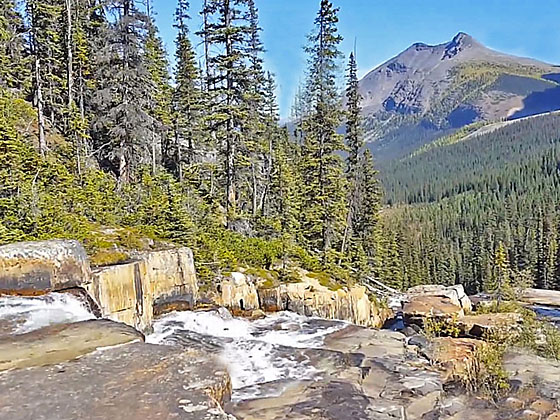
Reach the base of the waterfalls, a series of cascades spilling down rock shelves, at 6.2 miles. The area around the falls invites exploration. An unmarked trail climbs to the top of the falls. Progress will be slow as you frequently stop to take photos of the cascades as you ascend.
Beyond the top of the falls the North Fork of Paradise Creek spills down a series of picturesque large, flat rock outcroppings. This area and the top of the falls are perfect places for a picnic. Use care when climbing the wet rock along the falls and the flat rock outcroppings above the falls, the wet rock can be extremely slipper.
When you are done exploring the Giant Steps, retrace your steps to the trailhead.
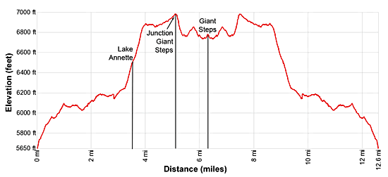
Elevation Profile
Driving Directions
From Lake Louise Village, AB, Canada to Paradise Valley Trailhead: The Lake Louise Village is located along the Trans-Canada Highway (AB-1). Take the Bow Valley parkway exit toward Lake Louise to reach the hotels and services area.
To reach the trailhead, head west on the Bow Valley Parkway which turns into Lake Louis Drive for 1.4 miles and turn left onto the Moraine Lake Road. Follow the road for 1.5 miles to the Paradise Valley parking area, located on the (right) west side of the road. Note: This is a VERY small parking lot that fills early.
From Banff, AB, Canada to Paradise Valley Trailhead: Head southwest on the Trans-Canada Highway (AB-1 W) for 33.9 miles and then take the Bow Valley Parkway exit toward Lake Louise. Turn left onto the Bow Valley Parkway which turns into Lake Louise Drive for 1.4 miles and then turn left onto the Moraine Lake Road. Follow the Moraine Lake Road for 1.5 miles to the Paradise Valley parking area, located on the (right) west side of the road. Note: This is a VERY small parking lot that fills early.
From Field, BC Canada to Paradise Valley Trailhead: Head east on the Trans-Canada Highway (BC-1 E), which turns into AB-1 when it crosses the border into Alberta, for 15.7 miles and then take the Bow Valley exit toward Lake Louise. Turn right, (west) on the Bow Valley Parkway which turns into Lake Louis Drive for 1.4 miles and then turn left onto the Moraine Lake Road. Follow the Moraine Lake Road for 1.5 miles to the Paradise Valley parking area, located on the (right) west side of the road. Note: This is a VERY small parking lot that fills early.
Trail Resources
Trail Intro / Trail Photo Gallery / Trail Map
Basecamp(s) Information:
Banff / Lake Louise
Region Information:
The Canadian Rockies
Other Hiking Regions in:
Alberta / British Columbia