Details: Helen Lake and Dolomite Pass 
Distance: 7.2 - 11.0 miles (round trip)
Banff National Park, near Banff in The Canadian Rockies
By: Diane Greer
Hike Facts
- Distance: 7.2 - 11.0 miles (round trip)
- Elevation: 6,430-ft. - 8,200-ft.
- Elevation Gain: 1,460-ft. - 1,770-ft.
- Difficulty: moderate-strenuous
- Trail Highlights: See Trail Intro
- Basecamp(s): Banff / Lake Louise
- Region: The Canadian Rockies
Vast meadows, pretty lakes, stunning scenery and a choice of destinations are the highlights of this popular hike to Helen Lake. Beyond the lake the trail climbs a panoramic ridge, visit Katherine Lake and Dolomite Pass and/or climbs Cirque Peak for breath-taking views.
Trailhead to Helen Lake
Distance from Trailhead: 7.2 miles (round trip)
Ending/Highest Elevation: 7,890-ft.
Elevation Gain: 1,460-ft.
The Helen Lake trailhead is located along the east side of the Icefield Parkway, across from the Crowfoot Glacier Viewpoint. (See the driving directions below).
The trail starts on the northeast side of the trailhead parking area. Follow the trail as it heads northeast, climbing on moderate to moderately steep grades through spruce-fir forest on the slopes of a ridge along the east side of the Bow Valley. Tree roots, exposed by trail erosion, are a minor irritation along the lower sections of the trail.
At 0.4 miles the grade abates as the trail curves to the right (southeast) and begins a traverse. This easy section comes to an end at 0.8 miles as the trail gradual swings to the left (northeast) and starts climbing on moderately-steep to steep grades. Openings in the trees a 1.3 miles offer views of BowCrow Peak (9,701-ft.) and Bow Peak (9,409-ft.) to the south across the Icefield Parkway.
At 1.6 miles the grade moderates. Soon the trees thin and give way to meadows. Views open to Bow Lake and Crowfoot Mountain (10,022-ft.), towering above the west side of the lake. Mount Andromache (9,950-ft) and Mount Hector (11,135-ft.) rise in the distance to the southeast above the east side of the Parkway.
At 1.8 miles the trail curves to the left (east) and climbs around the shoulder of the ridge, leaving the Bow Valley and entering the Helen Creek drainage at 2.0 miles. After a brief descent the trail turns to the left (northwest) and traverses through meadows scattered with conifers and wildflowers high above Helen Creek. Cirque Peak (9,819-ft.) and its amphitheater dominate the view at the head of the valley. Dolomite Peak (9,678-ft.) towers above the valley to the east.
At 2.7 miles the trail descends to circumvent a rock slide and then ascends on moderately steep grades, crossing Helen Creek at 3.1 miles. Beyond the crossing the climb continues through a huge meadow with fine views of Cirque Peak. Turn around for more views of Mounts Andromache and Hector to the southeast.
Reach the south shore of Helen Lake at 3.6 miles. On a calm morning Cirque Peak is reflected in the lake’s still waters. A rugged headwall rises beyond the east end of the lake.
Helen Lake is a great place to take a break and soak in the scenery. This is a popular spot so don’t expect solitude.
Helen Lake to the Ridge
Distance from Trailhead: 8.6 miles (round trip)
Ending/Highest Elevation: 8,200-ft.
Elevation Gain: 1,770-ft.
While the lake is a great destination, for fantastic views I highly recommend climbing the ridge above the head of the lake. To reach the ridge top, follow the trail as it traverses meadows along the east side of the lake. Midway along the shore the trail veers away from the lake and climbs through meadows and then rocky slopes up the valley’s headwall on moderately-steep grades. Near the top of the climb, at 4.1 miles, pass a trail branching to the left. This is the steep trail to Cirque Peak. We continue ascending on the main trail, reaching the top of the ridge at 4.3 miles.
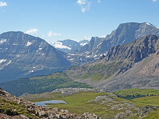
From the ridge crest enjoy incredible views of Bow Peak and Crowfoot Mountain along with a sea of summits in the Waputik Range to the west. Closer at hand Helen Lake lies cradled in Emerald Green meadows at the foot of the ridge. Cirque Peak dominates the view to the northwest. To the southwest Lake Katherine extends along the base of Dolomite Peak, which looks like the prow of a battleship. The Watermelon massif (10,150-ft.) fills the skyline to the west.
The ridge top invites exploration. A climb along the ridge crest offers panoramic views and an evolving perspective of the peaks to the west and southeast. Look carefully and you will see Mount Assiniboine rising in the gap between Bow Peak and Crowfoot Mountain.
To Lake Katherine and Dolomite Pass
Distance from Trailhead: 11.0 miles (round trip)
Ending/Highest Elevation: 7,865-ft.
Elevation Gain: -335-ft.
Hikers looking for a longer day can follow the trail that drops down the east side of the ridge to the tundra clad meadows on the plateau between Cirque and Dolomite Peaks. Initially the trail loses over 300-ft in a half mile and then traverse rocky meadows to the north shore of Lake Katherine at 5.1 miles.
The elongated, narrow lake lies nestled beneath the serrated cliffs of Dolomite Peak. Views stretch south across the lake to low point on a ridge which frames Bow Peak. On a clear day you can see summit Mount Assiniboine, an ice-clad horn, rising in the distance in the gap between Bow Peak and Crowfoot Mountain
The trail, really just a boot-beaten path, continues beyond the lake, climbing gently through alpine tundra. As you ascend be sure to turn around for even better views of the distinctively shaped horn of Mount Assiniboine.
Reach Dolomite Pass, located near a small tarn, at 5.5 miles. The pass is unmarked and its exact location is difficult to determine. From the pass the trail descends toward the Dolomite Creek Valley. Ahead are fine views of the rugged Watermelon massif. Bobac Mountain (10,131-ft.), visible if you descend a short distance toward the valley, rises to northwest of Watermelon Peak (10,150-ft.). The summit of Dolomite Peak towers above the valley to the southeast while Cirque Peak soars about the tundra-clad plateau to the west.
A challenging and strenuous backpacking trail descends along Dolomite Creek to the confluence of the Siffleur River. Talk to the Banff Backcountry rangers before considering this difficult backpack, which requires several deep creek crossings.
Helen Lake to Cirque Peak
Distance from Trailhead: 9.2 miles (round trip)
Ending/Highest Elevation: 9,819-ft.
Elevation Gain: 3,390-ft.
Cirque Peak offers stunning, 360-degree views of the high peaks of the Bow Valley, the Wapata Icefield, the summits lining the Dolomite Valley, Mount Hector (to the south) and the sea of peaks along the Icefield Parkway to the north of Bow Pass. The route, which is not for everyone, involves a stiff ascent along a rocky route and then a very steep climb up shifting scree slopes with a final scramble at the top. Only hikers comfortable on steep slopes and scrambling up slabs with some exposure should attempt the peak.
That being said, the views from the top are worth the effort. To reach the peak from Helen Lake, follow the trail traversing the meadows along the east side of Helen Lake. Midway along the shore the trail veers away from the lake and ascends through meadows and then rocky slopes up the valley’s headwall on moderately-steep grades. Near the top of the climb, at 4.1 miles, take the path branching to the left, which ascends steeply to the top of the ridge.
On the ridge, turn left (northwest) and climb through rock to the obvious trail ascending the scree slopes along the west facing slope of Cirque Peak. From here it is a stiff climb up very steep scree slopes. Loose scree slows forward progress. Reaching the first summit requires a 100-ft. scramble up rock slabs. A narrow ridge to the east connects the first summit with the true summit of Cirque Peak (9,819-ft) at 4.6 miles. There is some exposure on this section with steep drop-offs to the east and southeast.
The panoramic views from the summit are simply breathtaking. Mount Hector dominates the view to the south while the summits ringing the Bow Valley and Wapata Icefield fill the skyline to the west. To the east are the rugged mountains of the Banff backcountry and Siffleur Wilderness. A sea of peaks rims the Icefield Parkway to the north/northeast.
Note: The small summit can get crowded, especially on a beautiful day in the height of the summer. As always, it is best to get an early start to avoid the crowds.
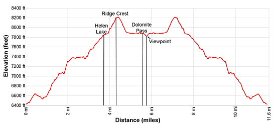
Elevation Profile
Driving Directions
From Lake Louise: Head north on the Trans-Canada Highway AB-1 N for 1.5 miles and then take the Icefields Parkway (AB-93 N) exit toward Jasper and Rocky Mountain House. Follow AB-93 for 21 miles and turn right into the Helen Lake/ Dolomite Pass trailhead parking lot on the east side of the Icefield Parkway. The trailhead is located across from the Crowfoot Glacier Viewpoint near the south end of Bow Lake.
From Banff: Head north on the Trans-Canada Highway AB-1 N for 36 miles and then take the Icefields Parkway (AB-93 N) exit toward Jasper and Rocky Mountain House. Follow AB-93 for 21 miles and turn right into the Helen Lake/ Dolomite Pass trailhead parking lot on the east side of the Icefield Parkway. The trailhead is located across from the Crowfoot Glacier Viewpoint near the south end of Bow Lake.
From Field, BC Canada: – Head east on the Trans-Canada Highway (BC-1 E), which turns into AB-1 when it crosses the border into Alberta, for 14.2 miles and then take the Icefields Parkway (AB-93 N) exit toward Jasper and Rocky Mountain House
Follow AB-93 for 21 miles and turn right into the Helen Lake/ Dolomite Pass trailhead parking lot on the east side of the Icefield Parkway. The trailhead is located across from the Crowfoot Glacier Viewpoint near the south end of Bow Lake.
Trail Resources
Trail Intro / Trail Photo Gallery / Trail Map
Basecamp(s) Information:
Banff / Lake Louise
Region Information:
The Canadian Rockies
Other Hiking Regions in:
Alberta / British Columbia