Details: Wilcox Ridge 
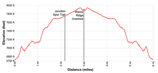
Distance: 2.0 - 6.0 miles (round trip)
Jasper National Park, near Jasper in The Canadian Rockies
Hike Facts
- Distance: 2.0 - 6.0 miles (round trip)
- Elevation: 6,730-ft. - 7,950-ft.
- Elevation Gain: 1,220-ft.
- Difficulty: easy-moderate
- Trail Highlights: See Trail Intro
- Basecamp(s): Jasper / Lake Louise
- Region: The Canadian Rockies
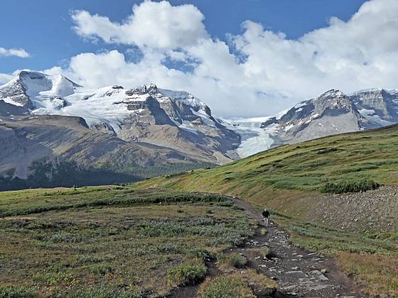
Unsurpassed, panoramic views of the high peaks and glaciers of the Columbia Icefield from the beautiful meadows along the eastern slopes of Mount Wilcox near the border of Banff and Jasper National Parks.
Trailhead to Wilcox Ridge
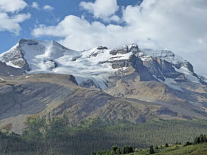
The Wilcox Ridge hike starts with a short, steep ascent through spruce-fir forest and then moderates, climbing a series of boardwalks and wood steps up a moss covered hillside. After a half mile the trail breaks from the trees and ascends on easy to moderate grades along a ridge offering fine views of the Athabasca Glacier, one of the six major toes of the Columbia Icefield. The 126-sq. mile Columbia Icefield, the largest glacier in the Rocky Mountains, straddles the Continental Divide and the border of Banff and Jasper National Parks.
Mount Andromeda (11,290-ft.) and Mount Athabasca (11,452-ft.) tower over the Athabasca Glacier to the south while Mount Kitchener (11,499-ft.) and ice-capped Snow Dome (11,340-ft.) rise to the northwest. The Dome Glacier, another of the major toes of the Columbia Icefield, spills down the slopes between Kitchener and Snow Dome. Nigel Peak’s (10,535-ft.) cliffs loom above the trail to the northeast.
The path briefly reenters the trees but soon emerges onto meadows scattered with willows and stunted conifers. As you ascend views open to Little A Glacier (aka North Glacier) clinging to Mount Atahabasca and two unnamed glaciers hanging from the slopes of and Mount Andromeda. The going is slow along this section of the ridge as each step unveils new perspectives of the peaks and glaciers.
Many people are content roaming along the lower section of the ridge and then returning to the trailhead for a 2.0-mile round-trip hike. I strongly recommend continuing the hike up the ridge for even better views.
At 1.0 mile the trail curves to the north and starts a short, steep climb along the east side of a gully carrying a stream. The grade moderates at 1.2 miles as the trail now ascends through beautiful alpine meadows on moderate grades. The meadows offer ever expanding views of the high peaks and glaciers. If you are lucky, you will see the resident herd of big horn sheep grazing in the meadows.
At 1.6 miles the trail curves to the northwest and now ascends on easy grades across vast meadows that encourage exploration. The Little A Glacier, on the slopes of Mt Athabasca is now in full view. View of the other peaks and glaciers are partially obscured by Mount Wilcox’s southeast ridge.
Ahead, views soon open to Wilcox Pass. Small tarns lie nestled in the meadows. Tangle Peak (9,842-ft.) rises to the northwest. Pyramid-shaped Sunwapa Peak (10,875-ft.) is seen in the distance through a low point along the ridge running between Tangle and Nigel Peaks.
At 2.1 miles reach a sign pointing left (southwest) toward a spur trail to Wilcox Ridge, 1.4 km (0.9 miles). Continuing straight ahead leads to Wilcox Pass and ultimately descends back to the Icefield Parkway at Tangle Falls, 6.3 miles from the Wilcox Campground trailhead.
For the best views of the hike, turn left on the spur trail toward Wilcox Ridge. The trail ascends an undulating landscape on easy grades, traveling through rocky meadows and over rock outcroppings to the ridge crest. As you ascend Mount Athabasca and Little A Glacier dominate the view to the south. Mount Coleman (10,285-ft) and the Cirrus Peak massif (10,728-ft.) rise in the distance to the southeast.
As you top the ridge stunning, bird’s-eye-views open up the length of the Athabasca Glacier. At the base of the glacier is a huge meltwater pond. You are now directly above the Columbia Icefield Discovery Center. At one time the Athabasca Glacier extended across the highway, filling the valley floor. To circumvent the glacier, outfitters followed the route of the Wilcox Ridge trail over Wilcox Pass and back to the valley floor.
The full mass of Mount Athabasca and Mount Andromeda are now in full view. All of the Little A Glacier is also visible as well as a portion of the Boundary Glacier on the east facing slopes of Mount Athabasca. The tongues of two hanging glaciers drip down the slopes of Mount Andromeda
To the northwest of the Athabasca Glacier the Dome Glacier spills down the slopes of ice-capped Snow Dome and Mount Kitchener. Mount Wilcox rises above the meadows to the north while Nigel Peak rims the valley to the east. Looking southeast, views extend down the Icefields Parkway to sheer southwest facing cliffs of the Cirrus Mountain massif.
When you are done soaking in the amazing views, retrace your steps to the trailhead. Along the way, enjoy more great views of the high peaks and glaciers.
Elevation Profile
Driving Directions
From Lake Louise, AB, Canada: Head north on the Trans-Canada Highway AB-1 N for 1.5 miles and then take the Icefields Parkway (AB-93 N) exit toward Jasper and Rocky Mountain House. Follow AB-93 for 77 miles and turn right on the access road for the Wilcox Creek Campground located on the east side of the Highway. The trailhead is located on the left side of the access road, 0.1 miles from the Parkway.
Note: The Wilcox Creek Campground is located 1.1 miles south of the Columbia Icefield Discovery Center.
From Banff, AB, Canada: Head north on the Trans-Canada Highway AB-1 N for 36 miles and then take the Icefields Parkway (AB-93 N) exit toward Jasper and Rocky Mountain House. Follow AB-93 for 77 miles and turn right on the access road for the Wilcox Creek Campground located on the east side of the Highway. The trailhead is located on the left side of the access road, 0.1 miles from the Parkway.
Note: The Wilcox Creek Campground is located 1.1 miles south of the Columbia Icefield Discovery Center.
From Jasper, AB, Canada: Drive south on the Icefields Parkway (AB-93 S) for 64 miles and turn left on the access road for the Wilcox Creek Campground located on the east side of the Highway. The campground is located 1.1 miles south of the Columbia Icefield Discovery Center. The trailhead is located on the left side of the access road, 0.1 miles from the Parkway.
Trail Resources
Trail Intro / Trail Photo Gallery / Trail Map
Basecamp(s) Information:
Jasper / Lake Louise
Region Information:
The Canadian Rockies
Other Hiking Regions in:
Alberta / British Columbia