Bishop Pass 
Distance: 4.0 - 11.0 miles (round trip)
John Muir Wilderness, Inyo National Forest, near Bishop in California's Southeastern Sierra
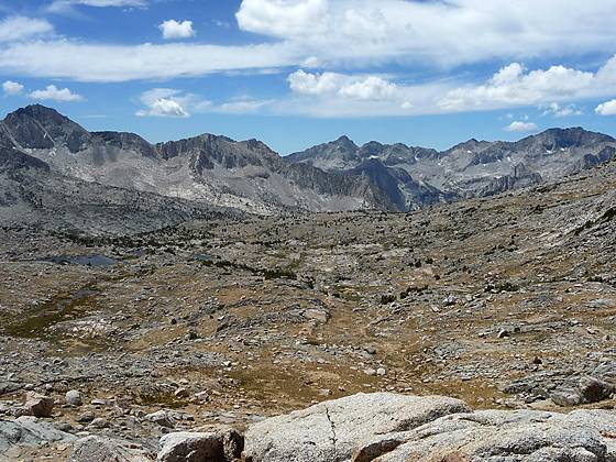
The panorama from the viewpoint below Bishop Pass
This excellent hike leads through a succession of beautiful lake basins to Bishop Pass (11,972-ft.), with spectacular views of Mount Agassiz, the Black Divide and Dusy Basin.
See Trail Detail/Full Description
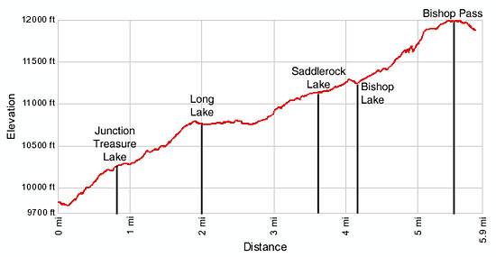
- Distance: 4.0 miles (round trip) to Long Lake
8.2 miles (round trip) to Bishop Lake
11.0 miles (round trip) to Bishop Pass - Elevation: 9,820-ft. at Trailhead
10,758-ft. at Long Lake
11,240-ft. at Bishop Lake
11,972-ft. at Bishop Pass - Elevation Gain: 938-ft. to Long Lake
1,420-ft. to Bishop Lake
2,152-ft. to Bishop Pass - Difficulty: moderate-strenuous
- More Hikes in:
Bishop / Mammoth Lakes / California's Southeastern Sierra
Why Hike Bishop Pass
The trail to Bishop Pass is one of the great hikes on the southeast side of the Sierras. The trail leads through a succession of beautiful lake basins to a high pass on the Sierra Crest, along the way enjoying great views of Hurd Peak, Mount Goode, the Inconsolable Range and Mount Agassiz. Extend the hike a short distance beyond the pass to a viewpoint with panoramic vistas of Dusy Basin and the peaks of the Black Divide.
Do not expect solitude on the trail. Dusy Basin and the lake basins along the trail are popular backpacking and fishing destinations. Competition can be fierce for overnight permits during the summer and the day use parking lot is often filled early. Don’t let the crowds deter you. Pick a beautiful day and get an early start to enjoy this classic hike.
Elevation Profile
Trail Resources
Trail Detail/Full Description / Trail Photo Gallery / Trail Map
Basecamp(s) Information:
Bishop / Mammoth Lakes
Region Information:
California's Southeastern Sierra
Other Hiking Regions in:
California