Details: Lamarck Lakes 
Distance: 4.4 - 5.8 miles (round trip)
John Muir Wilderness Area, Inyo National Forest, near Bishop in California's Southeastern Sierra
Hike Facts
- Distance: 4.4 - 5.8 miles (round trip)
- Elevation: 9,356-ft. - 10,918-ft.
- Elevation Gain: 1,306-ft. - 1,562-ft.
- Difficulty: strenuous
- Trail Highlights: See Trail Intro
- Basecamp(s): Bishop / Mammoth Lakes
- Region: California's Southeastern Sierra
A short, steep hike to two scenic lakes cradled in granite bowls and surrounded by rugged cliffs and photogenic peaks.
Trailhead to Lower Lamarck Lake
Distance from Trailhead: 4.4 miles (round trip)
Ending/Highest Elevation: 10,662-ft.
Elevation Gain: 1,306-ft.
From the trailhead parking area walk 0.6 miles up the North Lake Road to the trailhead bulletin board at the southwest end of the North Lake Campground. There is a single track trail that takes off to the right of the bulletin board. There is also a wide trail to the right of the bathrooms just beyond the bulletin board. The two trails join just beyond the last walk-in campsite.
I suggest taking the wide trail to the right of the bathrooms. The trail initially follows the path to Piute Pass. Just beyond the last of the walk-in campsites the trail splits. Turn left (south) to reach the Lamarck Lakes. The Piute Pass trail continues straight ahead.
In a short distance the trail crosses the two braided channels of Bishop Creek on wood plank bridges. Just beyond the last bridge the trail enters a forest of aspen and pines, passing the boundary for the John Muir Wilderness along the way. The trail now starts ascending a series of well engineered moderately steep switchbacks, gaining 600-ft. in 0.7 miles. Openings in the trees provide nice views of Mount Emerson and the red cliffs of Piute Crags across the valley.
Arrive at the junction with a spur trail to Grass Lake at 1.4 miles. Shortly past the junction the trail begins climbing steep, rocky switchback up the headwall of the Lower Lamarck Lake basin, gaining 700-ft. in 0.8 miles. Overlooks along the cliff face look down upon Grass and North Lake. To the south are the granite peaks and ridges rising above Grass Lake
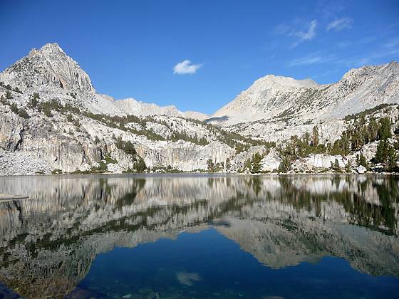
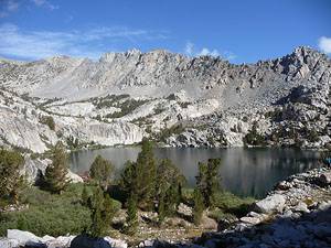
At the 2.0 mile mark the grade abates and the trail passes a small pond. A short distance past the pond the path reaches a short spur trail leading to the east shore of Lower Lamarck Lake (10,662-ft.), 2.2 miles from the trailhead.
Picturesque Lower Lamarck Lake sits in a small bowl at the east end of an elongated granite cirque. The lake’s shore is lined with sheer granite cliffs and large boulders. Scattered pines grow in crevasses and nooks along the shore. To the west Mt. George Davis (12,691-ft.) and an unnamed triangular peak dominate the scene. Cross-country routes lead west into the basin above the lake where the Wonder Lakes lie nestled beneath steep ridges.
The large slabs and boulders around the lake’s east shore provide scenic perches for lazing in the sun. Campsites are found along the east shore and at the edge of the bench to the east of the lake.
To Upper Lamarck lake
Distance from Trailhead: 5.8 miles (round trip)
Ending/Highest Elevation: 10,918-ft.
Elevation Gain: 1,562-ft.
To continue to Upper Lamarck Lake return to the main trail and head southwest. The trail drops down to and crosses the lake’s outlet stream (Lamarck Creek) and then climbs a rocky knoll on the other side. The grade abates as the trail traverses between two knolls reaching the southern end of the lake at 2.4 miles.
The trail now ascends a rocky slope above the stream channeling water between Upper and Lower Lamarck Lakes. Along the way enjoy nice views of the serrated ridge defining the north side of the basin.
Soon the way ahead constricts as the trail enters a narrow gully carrying the stream between the two lakes. Initially the trail stays to the right (southeast) or the stream. At 2.6 miles the trail crosses to the left (northwest) side of the creek. A small sign marks the crossing.
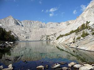
A short distance beyond the crossing the trail emerges from the gully and traverses a meadow. At 2.7 miles reach a small sign in the meadow with the word “Trail” and an arrow pointing left. Do not take this trail. The trail crosses the creek and passes a few campsites before it degenerates into a use trail/route that climbs to Lamarck Col. The route is used by backpackers to reach Darwin Bench and ultimately Evolution Valley. Instead continue along the northwest side of the creek to the outlet of Upper Lamarck Lake (10,918-ft.), 2.9 miles from the trailhead.
The long, narrow upper lake lies at the base of a dramatic cirque. Talus fields cascade down the steep ridges to the lake shore. At the head of the cirque Mt Lamarck (13,417-ft.) anchors a rugged ridge running along the Sierra Crest. For more extensive views of the lakes and surrounding peaks climb the granite hillsides on either side of the outlet stream.
After soaking in the views reverse your route and return to the North Lake trailhead.
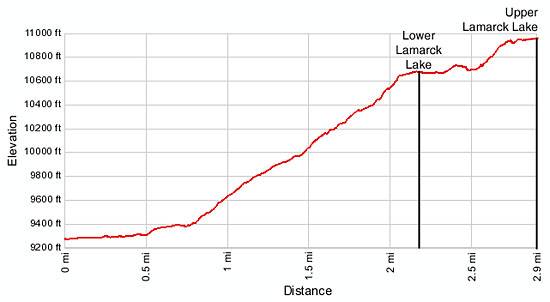
Elevation Profile
Driving Directions
From Hwy 395 in Bishop: Turn west on Line Street / Highway 168. Follow Hwy 168 toward Lake Sabrina for 18 miles. Shortly after Aspendell turn right onto the steep, narrow, mostly dirt North Lake Road. Drive 1.6 miles and turn right to park in the hiker parking lot near the Bishop Outfitters pack station. (The sign for the turn is beyond North Lake and somewhat obscured by brush growing along the side of the road.) The parking lot is 0.2 miles up the road.
To reach the trailhead walk back to the North Lake Road and turn right. Walk 0.4 miles up the road to the trailhead at the southwest end of the North Lake Campground. Parking in the campground is limited to people registered for campsites.
From Mammoth Lakes: Drive 3.1 miles southeast on Main Street / CA 203 E and turn right onto the entrance ramp for US 395 S. Follow US 395 south for 39.1 miles to Bishop and turn right (west) on Line Street /Highway 168. Follow Hwy 168 toward Lake Sabrina for 18 miles. Shortly after Aspendell turn right onto the steep, narrow, mostly dirt North Lake Road. Drive 1.6 miles and turn right to park in the hiker parking lot near the Bishop Outfitters pack station. (The sign for the turn is beyond North Lake and somewhat obscured by brush growing along the side of the road.) The parking lot is 0.2 miles up the road.
To reach the trailhead walk back to the North Lake Road and turn right. Walk 0.4 miles up the road to the trailhead at the southwest end of the North Lake Campground. Parking in the campground is limited to people registered for campsites.
Trail Resources
Trail Intro / Trail Photo Gallery / Trail Map
Basecamp(s) Information:
Bishop / Mammoth Lakes
Region Information:
California's Southeastern Sierra
Other Hiking Regions in:
California