Details: Duck Pass 
Distance: 7.2 miles (round trip)
John Muir Wilderness Area, Inyo National Forest, near Mammoth Lakes in California's Southeastern Sierra
By: Diane Greer
Hike Facts
- Distance: 7.2 miles (round trip)
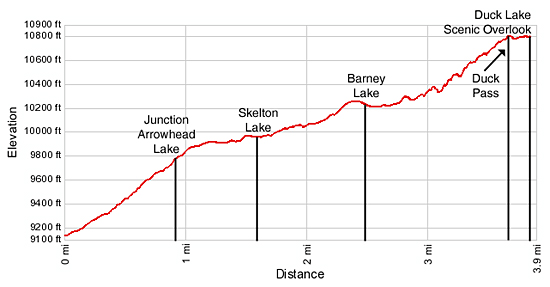
- Elevation: 9,120-ft. - 10,800-ft.
- Elevation Gain: 1,680-ft.
- Difficulty: moderate
- Trail Highlights: See Trail Intro
- Basecamp(s): Mammoth Lakes
- Region: California's Southeastern Sierra
This nice hike visits two scenic lakes and then climbs to a pass on the Pacific Crest with great views of the lakes basin. An overlook to the south of the pass provides panoramic views of Duck Lake and the Silver Divide.
Trailhead to Duck Pass
The trail to Duck Pass starts at the south end of the trailhead parking area. Follow the trail as it heads southeast, climbing a forested hillside on moderately steep switchbacks. Pass the boundary of the John Muir Wilderness at 0.2 miles and reach the junction with the Arrowhead Lake trail, branching left, at 0.9 miles. The trail to Duck Pass continues straight ahead.
Just beyond the junction the grade abates a bit as the trail continues its ascending traverse up the valley across granite outcroppings. Openings in the trees provide nice views of the ridge rising along the east side of the valley.
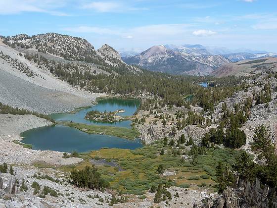
A short distance before Skelton Lake the grade eases as the trail travels along the southwest side of a pretty meadow and the stream linking Skelton and Arrowhead Lake. At 1.6 miles pass the spur trail leading the western shore of Skelton Lake (9,924-ft.). Pines grow amid small meadows and on granite outcroppings around the lake shore. A craggy ridge dominates the skyline to the east. From the shore views extend southeast to the peaks and ridges rising at the head of the valley.
As you reach the head of Skelton Lake the climb resumes through forested hillsides and meadows cleared by avalanches tumbling down the steep slopes to the west of the trail. Along the way the path rock hops across a small stream and enjoys some nice views of the rugged ridge towering over the valley to the east.
At 2.4 miles the trail crests the rim of the upper lakes basin and reaches a viewpoint above the Barney Lake’s (10,210-ft.) north shore, 2.5 miles from the trailhead. The lake lies in a stark bowl at the head of the valley. Rocky meadows sprinkled with scrub willows and stunted pines line the eastern shore. Scree fields tumble down the sheer slopes along the west side of the lake. Granite crags and talus covered the steep headwall to the south.
From the viewpoint the trail drops down to and crosses Barney’s outlet stream on two wood logs. Before and after the crossing spur trails head left beside the outlet stream to pretty Red Lake, a tiny lake to the northeast of Barney Lake.
Past the outlet stream the path travels along the east side of Barney Lake. At the head of the lake the trail climbs the headwall on steep rocky switchbacks dotted with small copses of stunted whitebark pines. As you climb enjoy every improving views of the lakes basin and the rugged cliffs lining the valley. Mammoth Mountain (11,030-ft.) dominates the skyline to the northwest. Near the top of the climb the tops of the Minarets appear above ridge to the west.
Reach to top of Duck Pass (10,800-ft.), located on a broad saddle along the Pacific Crest, 3.6 miles from the trailhead. The best views from the pass are gained by dropping down a short distance on either side of the saddle. Just beyond the south side of the saddle is a junction with the trail to Pika Lake, heading to the left (southeast). The trail to Duck Lake curves to the right (southwest).
For panoramic views of Duck Lake (10,482-ft.) and the surrounding peaks I recommend descending 0.2 miles down the south side of the pass and finding a nice lunch spot in the rocky meadows high above the lake. From this vantage point the huge 222-acre lake, one of the largest natural lakes in Eastern Sierras, lies cradled in a huge cirque of jagged 11,000-ft. peaks and ridges. Smaller Pika Lake is tucked beneath the rugged cliffs to the southeast of Duck Lake. Stunning Silver Peak and the Silver Divide fill the skyline to the southwest.
After soaking in the view retrace your steps to the trailhead.
Elevation Profile
Driving Directions
From Mammoth Lakes: Head west on Highway 203 (Main Street). Main Street changes its name to Lake Mary Road at the intersection with Minaret Road. Follow the Lake Mary Road for 3.6 miles to a fork just before Lake Mary. Bear left at the fork, following the signs for the Coldwater Campground. (The road travels around the east side of the lake.) Turn left at the Campground, 0.6 miles after the fork, and follow the road through the campground for 0.7 miles to the trailhead parking area, located at the end of the road. The Duck Pass trailhead is located at the south end of the parking area.
Trail Resources
Trail Intro / Trail Photo Gallery / Trail Map
Basecamp(s) Information:
Mammoth Lakes
Region Information:
California's Southeastern Sierra
Other Hiking Regions in:
California