Details: Alta Peak 
Distance: 13.8 miles (round trip)
Sequoia-Kings Canyon National Park, near Lodgepole in California's Southwestern Sierra
By: Diane Greer
Hike Facts
- Distance: 13.8 miles (round trip)
- Elevation: 7,280-ft. - 11,204-ft.
- Elevation Gain: 3,924-ft.
- Difficulty: strenuous-difficult
- Trail Highlights: See Trail Intro
- Basecamp(s): Lodgepole
- Region: California's Southwestern Sierra
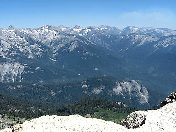
Alta Peak offers some of the best views in the southern Sierras. From its lofty summit breath-taking vistas extend from the Sierra Crest, the Great Western Divide and the Kaweah Peaks to the foothills of the San Joaquin Valley.
Trailhead to Alta Peak
The “official” Alta Peak trail begins in Giant Forest. The shortest route, and the one I recommend, starts in Wolverton and initially follows the Lakes Trail.
From the Lakes trailhead, located on the north side of the Wolverton parking area, the path heads north, climbing a few stairs and then ascends on moderate grades to a trail junction near the top of a ridge at 0.1 miles. At the junction the trail to the left descends to Lodgepole. Turn right (east) and follow the Lakes Trail as it ascends on easy to moderate grade through trees along or near the top of the ridge for one mile. Wolverton Creek, hidden by the trees, flows below the trail to the south.
At 1.1 miles the trail curves to the southeast, following the course of Wolverton Creek. Shortly after crossing a small stream the trail turns left (east) and arrives at the junction with the Heather/Pear Lake trail, which branches to the left (north), 1.8 miles from the trailhead. We turn right (southeast) and follow the trail to Alta Peak and Mehrten Meadows.
Beyond the junction the trail continues is moderate ascent through red fir forest sprinkled with small meadows for one mile to the Alta Trail at Panther Gap (8,450-ft.), located 2.8 miles from the trailhead. The Gap is situated 5,000-ft. above the Middle Fork Kaweah River and enjoys fine views to the southeast of the peaks along the Great Western Divide.
Turn left (east) onto the Alta Trail toward Alta Peak and the High Sierra Trail. (Turning right (west) on the Alta Peak trail leads to Giant Forest in 5.7 miles.) For the next mile the trail follows a moderate ascending traverse along the steep hillside with ever improving views of the Great Western Divide and the Castle Rocks to the south. Along the way the trail crosses a few avalanche chutes where seeps water pretty wildflower displays.
Soon the trail curves around the end of a ridge and reaches the junction with the High Sierra Trail, branching to the right, at 3.8 miles. Our trail veers to the left to Alta Peak and Mehrten Meadows. Mehrten Meadows, a popular camping site in pretty little glade, appear below the trail to the right in 0.2 miles. Views of the meadow are partially obstructed by trees.
Continue along the trail as it ascends on easy to moderate grades through forest to the Alta Peak junction, reached at 4.8 miles. Here you have a choice. To the right is an easy one mile long trail to Alta Meadows, a wildflower filled expanse with excellent views of the Great Western Divide, Tharps Rock and Alta Peak. To the left is the path to Alta Peak, which climbs almost 2,000-ft. in 2.1 miles.
To continue to the peak turn left. The trail climbs steeply through an avalanche chute and then enters the trees as it curves around Tharps Rock. Along the eastern flanks of Tharps Rock the trees thin and wonderful views open to the Great Western Divide. Below, to the southeast, is Alta Meadow. Tharps Rock looms above the trail.
At 5.8 miles the grade eases as the trail crosses a gully with a small stream lined with wildflowers. Beyond the gully the trail climbs a long switchback traversing the south slope of Alta Peak to a point that is almost level with the top of Tharps Rock, at 6.3 miles. En route the path passes a few interesting gnarled foxtail pines.
The final push to the summit climbs steeply up a sandy trail beneath the southwest ridge of Alta Peak. Soon you leave the last of the trees behind and enter a stark, rock strewn landscape enlivened with small patches of ground cover sprinkled with tiny flowers.
The trail ends at the crest of the ridge below the summit block. From here you will need to use your hands for the final scramble up broken rock slabs to the top of Alta Peak (11,204-ft.), 6.9 miles from the trailhead.
At the summit hikers are greeted with stunning 360-degree views. To the northeast the Sierra Crest forms the backdrop for the huge granite expanse of the Tablelands. To the east/southeast are the peaks of the Great Western Divide and the Kaweah Peaks. To the south and west are the rolling forested hills of the Middle Fork Kaweah Valley and the San Joaquin valley beyond. Emerald and Peak Lake lie nestled in granite bowls 1,700-ft below the trail to the northwest.
It is tough to pull yourself away from this amazing spot. After taking in the views, retrace your steps, enjoying the wonderful views on the now easy decent.
Consider an overnight backpacking trip if you do not feel capable of hiking to the peak in one day. Nice campsites are available at Mehrten and Alta Meadows. See the Wilderness Permits page on the Sequoia National Park website for more information.
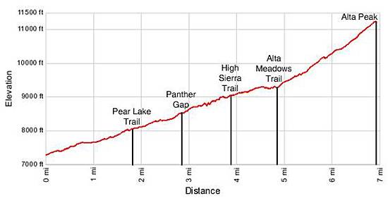
Elevation Profile
Driving Directions
From Three Rivers / Highway 198: Follow Highway 198 / the Generals Highway for 25 miles, through entrance station for Sequoia-Kings Canyon National Park to Giant Forest, passing the Giant Forest Museum along the way. About 0.5 miles beyond the handicapped parking area for the General Sherman Tree turn right (east) onto the Wolverton Road. The road is signed for the main parking area for the General Sherman Tree. Travel along the Wolverton Road to its end, 1.4 miles from Highway 198/Generals Highway. Turn left into the large parking area and park near the trailhead on the north side of the lot.
From Fresno / Highway 180: Follow Highway 180 east for 60.8 mile, past the entrance station for Sequoia-Kings Canyon National park, to the junction where Highway 180 splits off left (north) towards Grant Grove and Highway 198 heads right (southeast) towards the Giant Forest in Sequoia. Turn right onto Highway 198/Generals Highway towards Sequoia National Park and follow the road for 26.2 miles, passing the Wuksachi Lodge and Lodgepole Village along the way. Turn left (east) onto the Wolverton Road. (The Wolverton road is 1.6 miles south of Lodgepole Village on Highway 198/Generals Highway and is signed for the main parking area for the General Sherman Tree.) Travel along the Wolverton Road to its end, 1.4 miles from Highway 198/Generals Highway. Turn left into the large parking area and park near the trailhead on the north side of the lot.
Trail Resources
Trail Intro / Trail Photo Gallery / Trail Map
Basecamp(s) Information:
Lodgepole
Region Information:
California's Southwestern Sierra
Other Hiking Regions in:
California