Details: Capitol Lake (aka Capitol Creek Trail) 
Distance: 12.8 miles (round trip)
Maroon Bells_Snowmass Wilderness, White River National Forest, near Aspen in Central Colorado
Hike Facts
- Distance: 12.8 miles (round trip)
- Elevation: 9,475-ft. - 11,580-ft.
- Elevation Gain: 2,105-ft.
- Difficulty: strenuous
- Trail Highlights: See Trail Intro
- Basecamp(s): Aspen
- Region: Central Colorado
This long hike ascends a pretty valley through aspen groves and spruce-fir forest interspersed with meadows to Capitol Lake, an alpine jewel nestled beneath the massive west face of Capital Peak (14,130-ft.).
Trailhead to Capitol Lake
Distance from Trailhead: 12.8 miles (round trip)
Ending/Highest Elevation: 11,580-ft.
Elevation Gain: 2,105-ft.
The Capitol Creek trailhead (see driving directions) is located on a ridge overlooking the Capitol Valley with wonderful views of massive Capitol Peak (14,130-ft.) towering above the head of the valley. Two trails depart from the ridge and lead up the valley, Capitol Creek Trail #1961 and Upper Capitol Creek Trail #1963 (aka the Ditch). I prefer the Ditch Trail (see the description below.)
Capitol Creek Trail #1961 drops off the ridge, heading downhill on switchbacks through sagebrush and scrub oak to the valley floor, losing 425-ft. in 0.7 miles. On the valley floor the trail hops over an irrigation ditch and then traverses a large meadow to the opposite side of the valley where it crosses a wooden bridge spanning Capitol Creek.
On the other side of the bridge is a junction with the Nelson Creek trail, which turns left (east). We follow the Capitol Creek trail to the right (southwest) as it ascends the east side of the valley on moderate grades through pretty aspen groves.
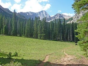
At 1.9 miles the trail passes through a meadow with nice views of Capitol Peak and Mount Daly, rising to the east (left) of Capitol Peak. For the next mile the path continues its journey up valley through mixed conifer stands and small meadows sprinkled with wildflowers.
At 2.9 miles the trail curves west to circumvent a ridge. En route the path tunnels through a tall thicket of willows, crosses a creek draining the western flank of Haystack Mountain and then ascends a large meadow. At the end of the meadow the path veers south and reenters the trees, arriving at the junction with the Capitol Ditch trail (see description below) at 3.3 miles.
Beyond the junction the trail wanders past a few ponds and then traverses a large meadow providing nice views of Capitol Peak and the red sandstone ridge rimming the western side of the valley. Soon the path arrives at the junction with the West Snowmass trail, descending the hillside from the east, at 3.8 miles.
Our path now passes through thick stands of conifers interrupted by a series of meadows cleared by avalanches tumbling down the steep slopes to the east and west of the trail. From the meadows Capitol Peak and a few lesser granite crags loom above the head of the valley.
Up to this point you may have run into cows grazing in the meadows. At 4.3 miles reach a wooden fence marking the boundary for the grazing allotment in a large copse of mixed conifers. Be sure to close the gate to insure the cows do not wander any further up valley.
Past the fence the grade steepens as the trail passes through trees and meadows offering intermittent views of the rugged cliffs and craggy peaks lining the valley. At 5.1 miles the path emerges from the trees and crosses a large meadow formed by avalanches spilling down the slopes of Mt Daly. At the end of the meadow the trail switchbacks steeply up a wooded headwall. Openings in the forest provide nice views down valley.
At the top of the headwall the path crosses Capitol Creek on a log at 5.4 miles. The trail, now on the west side of the stream, follows the winding course of the stream along the edge of a meadow, skirting a talus field. The meadow offers great views of Mt. Daly rising above the eastern side of the valley.
At 5.7 miles the trail crosses back to the east side of the creek and resumes its steep ascent, heading southeast through beautiful meadows with thigh-high wildflowers. Soon you will pass the first of 9 designated campsites, requiring advanced reservation on recreation.gov.
From this point to Capitol Lake the trail gains 550-ft in 0.7 miles. Wonderful views of Capitol Peak towering over the head of the valley and the interesting jagged peaks and craggy ridges rising to the west help divert your attention from the climb.
Follow the trail as it ascends the eastern side of the valley to skirt a rocky knoll at the head of the basin. Soon the path crosses a creek, curves to the right and passes a trail branching right to four more designated camping sites requiring advanced reservations.
The trail now climbs through beautiful meadows to the lake. Just before reaching the lake the path meets two unmarked trail junctions. At the first junction a faint climbers trail heads left (east), ascending to the northeast ridge of Capitol Peak. Another faint trail goes right (west) to four more advanced reservation campsites on a rocky knoll.
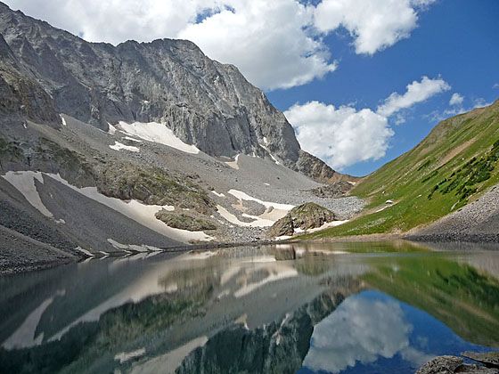
Just a few feet beyond the first junction the trail splits at the second unmarked junction. The left fork leads to the north end of the Capitol Lake (11,580-ft.), an azure jewel cradled beneath the steep west face of Capitol Peak, at 6.4 miles. On calm days the lake provides beautiful reflections of the peak’s massive west face, towering 1,800-ft. above the south end of the lake.
A side trip to pass above the lake is highly recommended. To reach the pass, return to the second unmarked junction and take the right fork. The trail now winds through talus slopes along the west (right) side of the lake and then climbs through meadows to a saddle on the ridge (12,060-ft.), which some refer to as Capitol Pass, which connects with the Avalanche Creek trail. From the saddle enjoy great views of Capitol Lake, Capitol Peak and the high peaks towering above the Avalanche Creek Valley to the west. The side trip to the pass adds 1.6 miles (RT) and 480-ft in elevation gain to the hike.
After relaxing at the lake retrace your steps to the trailhead. For variety consider taking the Capitol Ditch trail (see below) on the return leg.
Alternative Start: Capitol Ditch Trail
Distance from Trailhead: 3.2 miles (one way)
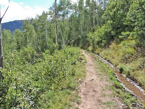
This is my preferred start to the Capital Lake Trail. The Capital Ditch trail leaves from the western end of the trailhead parking area and travels alongside an irrigation ditch beneath the ridge defining the western side of the valley. The trail and the ditch follow the arc of the valley as it curves south toward Capitol Peak. At 1.4-miles the trail leaves the irrigation ditch behind and ascend the hillside through aspen and conifer stands, gaining about 500-ft. in 1.0 mile. As you climb, the trees give way to meadows with wonderful views of Capital Peak.
After 2.4 miles the trail tops out and then descends to Capitol Creek at a wide ford at 3.2-miles. Look up stream for a good place to cross the creek. Early in the season you will need to wade the creek. After the runoff abates you should be able to find a shallow place to cross and keep your feet dry.. On the other side of the creek turn right (south) at the junction with the Capitol Creek Trail #1961. Continue up the trail as per the description above.
Note: There are a number of good camping spots around the trail junction on the west side of the creek.
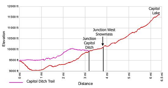
Elevation Profile
Buy the BookThis opinionated guide includes all the hikes in the Aspen, Buena Vista, Crested Butte, Marble and Leadville sections of the website plus info on local services and nearby attractions. | |

Driving Directions
Driving Directions from Aspen:
Drive 14 miles west of Aspen on Highway 82 to Old Snowmass and turn left on Snowmass Creek Road (just past to the Conoco Gas station on the south side of the highway). Continue 2 miles to a "T" intersection and turn right. Drive 5 miles to the end of the pavement and then continue on the dirt road for another 3 miles to the trailhead. The last mile is on a rough 4WD road. If you don't have a 4WD, park in the BLM meadow on the right approximately 2.25 miles below the trailhead. Note: The road continues past the Capitol Creek Trailhead and climbs very steeply to the Hell Roaring Trailhead. The road is slick when wet.
Trail Resources
Trail Intro / Trail Photo Gallery / Trail Map
Basecamp(s) Information:
Aspen
Region Information:
Central Colorado
Other Hiking Regions in:
Colorado