Details: Browns Pass via Denny Creek 
Distance: 7.6 - 10.2 miles (round trip)
Collegiate Peaks Wilderness, San Isabel National Forest, near Buena Vista in Central Colorado
By: Diane Greer
Hike Facts
- Distance: 7.6 - 10.2 miles (round trip)
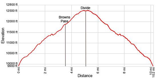
- Elevation: 9,910-ft. - 12,550-ft.
- Elevation Gain: 2,110-ft. - 2,640-ft.
- Difficulty: moderate-strenuous
- Trail Highlights: See Trail Intro
- Basecamp(s): Buena Vista
- Region: Central Colorado
The ascent of the Denny Creek valley to Brown’s pass features terrific view of the 14er’s in the Collegiate Peaks Wilderness. Extend the hike with a high traverse to a saddle overlooking the North Cottonwood Creek with more great views of the high peaks of the Sawatch Range.
Trailhead to Browns Pass
Distance from Trailhead: 7.6 miles (round trip)
Ending/Highest Elevation: 12,020-ft.
Elevation Gain: 2,110-ft.
There are three ways to get to Brown’s Pass; from the Denny Creek trailhead, the North Cottonwood Creek trailhead and the Texas Creek trailhead. This description, starting from the Denny Creek trailhead, is the shortest way to the pass and includes an optional extension to a saddle overlook the upper North Cottonwood Creek valley.
From the Denny Creek parking area the Brown’s Pass/Denny Creek trail heads north climbing steep switchbacks up an old, rocky road through a forest of Lodgepole Pines. Shortly after passing the boundary of the Collegiate Peaks Wilderness at 0.25 miles the grade ease and the old road curves to the northwest, continuing its ascent on moderate grades through mixed forest along the left (west) side of Denny Creek.
Cross to the right (east) side of Denny Creek on a log bridge at 1.0 mile and then cross a smaller stream a short distance beyond. Openings in the trees offer a brief glimpse of Mount Yale (14,196-ft.) towering above the valley to the northeast.
Pass the trail to Mount Yale on the right (east) at 1.3 miles. Soon the trees thin as the trail travels through an old burn. Views open to the peaks rising to the west. Mt. Princeton (14,197-ft.) fills the skyline to the southeast (behind you).
Top a small rise at 1.8 miles and enjoy views of Tuner Peak (13,237-ft.) and the unnamed peaks rising above the Hartenstein Lake basin to the west. Mt. Yale towers above the valley to the east. To the southeast are more great views of Mt. Princeton.
At 2.0 miles pass the trail to Hartenstein Lake branching to the left (west). Here the old road turns left. Stay right, now on a trail, that travels on easy grades through a meadow and then turns left (northwest) and crosses to the west side of North Fork of Denny Creek on a log bridge. There are some nice campsites in the trees to the west of the crossing.
Beyond the crossing the trail enters the trees and soon turns north, following an undulating course along the low hills on the west side of the valley. The valley bottom, seen through the trees, is choked with willows.
After a short descent the trail climbs two switchbacks and then curves to the northeast, emerging from the trees near the head of the valley at 3.2 miles. The path now travels through shoulder high willows as it rock hops across the nascent North Fork Creek. On the north side of the creek the trail ascends on steep grades through dense willows along the east side of the valley.
Soon the willows thin and give way to small meadows. Reach a bench at 3.5 miles with fine views of the Mt.Antero (14,276-ft.) and the peaks to the south. Turner Peak (13,237-ft.) rises to the southwest.
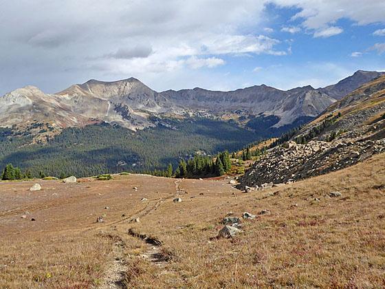
The trail now curves to the northwest, ascending on moderately-easy grades through meadows and scatters clumps of low willows. The pass, a low saddle on the ridge, is now in view. Finally the willows give way to alpine tundra as the trail climbs on moderate grades to Brown’s Pass (12,020-ft.) on the Continental Divide at 3.8 miles.
From the pass enjoy a stunning panorama to the north/northwest of the peaks and ridges along the Continental Divide rising above the Texas Creek valley, including the Three Apostles. In the distance, Mt. Harvard (14,420-ft.), Mt. Oxford (14,153-ft.), Mt. Bedford (14,197-ft.) and Emerald Peak (13,904-ft.) rise beyond the Divide. To the south the distinctive shaped Mt. Antero Peak punctuates the skyline above a sea of peak in the Sawatch Range while Turner Peak and several unnamed summits dominate the views to the southwest.
The pass offers an opportunity to trace the Continental Divide as it snakes east from the pass, eventually curving around the head of Texas Creek and back along the ridges and peaks rimming the north side of Texas Creek. To the west the divide climbs the ridge beyond the pass before turning southwest to follow the ridge along the west side of the Denny Creek valley.
History buffs will want to descend 0.3 miles down the north side of the pass to the ruins of Brown’s Cabin and the remnants of the nearby mine openings. This side trip loses over 300-ft. on the way to the cabin.
To North Cottonwood Creek Divide
Distance from Trailhead: 10.2 miles (round trip)
Ending/Highest Elevation: 12,550-ft.
Elevation Gain: 2,640-ft.
If time, energy and the weather permit, I strongly recommend extending the hike by continuing to the divide separating the Texas Creek and North Cottonwood Creek valleys. This detour adds 2.6 miles round trip and 530-ft. of elevation gain to the hike. The extra effort is amply rewarded with terrific views.
At Brown’s Pass a signed trail heads east toward Kroenke Lake. Follow the trail as it climbs switchbacks through alpine tundra up the ridge along the south side of the Continental Divide. As you gain elevation, enjoy every improving views of Mt. Princeton and Mt. Antero to the south and the peaks rising along the west side of the Denny Creek valley.
At 4.4 miles the trail crosses to the north side of the divide and then ascends on easy grades along the northeast face of a low, unnamed peak. As you cross the tundra views encompass the sea of peaks rising above and beyond the north side of the Texas Creek valley. The distinctive profile of the Three Apostles marks the northwest end of the valley. Mt. Columbia (14,073-ft.), Mt. Harvard, Mt. Oxford and Mt. Belford punctuate the skyline to the north/northeast. To the west distant views extend to the Elk Mountains.
Reach the high point of the hike (12,550-ft.) at 4.9 miles. From here the trail gently descends to the divide overlooking the head of the North Cottonwood valley. Mt. Yale dominates the views to the southeast while Mt Columbia rises to the northeast. To the north/northwest are more great views of the high summits of the Collegiate Peaks. The Elk Mountains fill the skyline to the west.
When you are done taking in the views, retrace your steps to the trailhead for a 10.2 mile round-trip hike. With a car drop or second vehicle, hikers can continue over the east side of the divide on a trail that drops down to Kroenke Lake and then descends to the North Cottonwood Creek trailhead.
Elevation Profile
Buy the BookThis opinionated guide includes all the hikes in the Aspen, Buena Vista, Crested Butte, Marble and Leadville sections of the website plus info on local services and nearby attractions. | |

Driving Directions
Driving Directions from Buena Vista: From the traffic light at the intersection of U.S.24 and Country Road 306 in downtown Buena Vista, drive west on CR 306 for 12 miles and turn right (north) into the paved Denny Creek Trailhead parking area. The parking area is about a mile beyond the Collegiate Peaks Campground (located along the left (south) side of CR 306). There is additional parking in a gravel lot just to the east.
Note: This is a very popular trailhead providing access to Hartenstein Lake, Mount Yale and Brown’s Pass. The parking area fills early during the height of the summer hiking season.
Trail Resources
Trail Intro / Trail Photo Gallery / Trail Map
Basecamp(s) Information:
Buena Vista
Region Information:
Central Colorado
Other Hiking Regions in:
Colorado