Details: Ptarmigan Lake 
Distance: 6.2 - 6.8 miles (round trip)
San Isabel National Forest, near Buena Vista in Central Colorado
By: Diane Greer
Hike Facts
- Distance: 6.2 - 6.8 miles (round trip)
- Elevation: 10,680-ft. - 12,300-ft.
- Elevation Gain: 1,620-ft.
- Difficulty: moderate
- Trail Highlights: See Trail Intro
- Basecamp(s): Buena Vista
- Region: Central Colorado
This family-friendly scenic hike climbs on moderate grades to a lovely lake with terrific views of Mount Yale (14,196-ft.) and Turner Peak to the north, the Gladstone Ridge to the east and Jones Mountains to the West.
To Ptarmigan Lake and the Saddle
The signed trail to Ptarmigan Lake starts from the south end of the trailhead parking lot. Follow the trail as it heads south through spruce-fir forest and soon crosses a bridge over Middle Cottonwood Creek. Beyond the bridge the trail curves to the left (east) and ascends on easy to moderate grades. The trail briefly breaks out of the trees to reveal views of Turner Peak (12,327-ft.) and Peak 12739 rising along the north side of the Middle Cottonwood Creek Valley.
At 0.5 miles the trail crests a minor ridge and curves to the right (south) into the Ptarmigan Creek Valley. The path now ascends on moderate grades through forest along the right (west) side of Ptarmigan Creek. The creek is heard but seldom seen as you climb the valley. As the trail crosses an old rock slide views open to the Gladstone Ridge (13,208-ft.) rimming the east side of the valley.
Past the slide the trail plunges back into the trees and continues its ascent. The path curves right (west) at 1.25 miles and climbs switchbacks up a hillside. En route pass an old Forest Service Road at 1.4 mile. Soon the trail curves to the left (southwest) and resumes its ascent up the valley.
At 2.4 miles the trees thin as the trail passes between an unnamed lake to the left (east) and a small pond to the right (west). Views open to the Jones Mountain massif lining the west side of the valley. The rugged Gladstone Ridge forms a backdrop for the lake to the east. Several nice campsites are situated among the trees on both sides of the trail.
Beyond the lake the grade steepens as the trail climbs through meadows with scattered willows and trees. Turn around for great views of Mount Yale (14,196-ft.) towering above the north side of the Middle Cottonwood Valley.
Leave the last of the trees behind at 2.7 miles. The path now ascends through meadows and clusters of willows toward the head of the valley, crossing the outlet stream of a small pond to the west of the trail. Views open to a saddle at the head of the valley between Gladstone Ridge and the Jones Mountains. Behind you, to the north, are more great views of Turner Peak and Mount Yale.
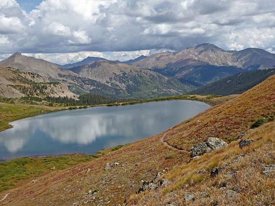
At 2.9 miles the trail turns east and climbs on moderately-steep grades to a bench. As you crest the bench Ptarmigan Lake (12,150-ft.) springs into view at 3.1 miles. The beautiful lake lies nestled beneath the north face of Jones Mountain and is surrounded by pretty meadows and willow thickets. Fishermen are often seen on the surrounding shores casting for the lake's native cutthroat trout.
For even better views follow trail around the eastern shoreline to the head of the lake. From this vantage point Turner Peak and Mount Yale form a stunning backdrop for this pretty alpine lake. Early in the day, before the wind picks up, you may be lucky enough to see the peaks reflected in the lake’s still waters.
If time and energy permit, extend the hike by climbing the short, steep trail to the saddle (12,300-ft.) at the head of the valley at 3.4 miles. From the saddle enjoy lovely bird’s-eye views of Ptarmigan Lake. To the north panoramic views encompass Turner Peak, Brown’s Pass, Mount Yale and the summits rising to the north of Texas Creek. To the south the saddle overlooks the South Cottonwood Valley rimmed by 13,000-ft. peaks extending west from Mount Princeton and the 12,000-ft peaks lining Morgan’s Gulch.
When you are done enjoying the views, retrace your steps to the trailhead. The return hike is filled with more great views of Mount Yale and Turner Peak, which are now front and center as you descend the valley.
Elevation Profile

Buy the BookThis opinionated guide includes all the hikes in the Aspen, Buena Vista, Crested Butte, Marble and Leadville sections of the website plus info on local services and nearby attractions. | |

Driving Directions
Driving Directions from Buena Vista: From the traffic light at the intersection of U.S.24 and Country Road 306 in downtown Buena Vista, drive west on CR 306 for 14.4 miles and turn left (south) on to the signed road for the Ptarmigan Lake trailhead. Follow the short paved road as it curves southwest to a small parking area with an outhouse. The signed trailhead is located along the south end of the parking lot.
If the parking lot if full, there are a few spaces along the access road. There are also some places to park along CR 306 near the trailhead. Make sure you select a spot that is well off the highway and does not block the entrance to the spur road.
Trail Resources
Trail Intro / Trail Photo Gallery / Trail Map
Basecamp(s) Information:
Buena Vista
Region Information:
Central Colorado
Other Hiking Regions in:
Colorado