Details: Oh Be Joyful and Blue Lake 
Distance: 13.2 miles (round trip)
Raggeds Wilderness, Gunnison National Forest, near Crested Butte in Central Colorado
Hike Facts
- Distance: 13.2 miles (round trip)
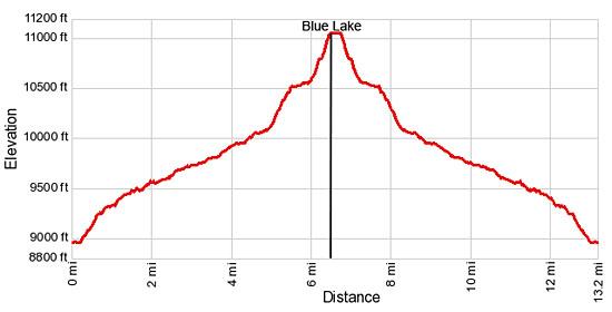
- Elevation: 8,960-ft. - 11,075-ft.
- Elevation Gain: 2,115-ft.
- Difficulty: moderate-strenuous
- Trail Highlights: See Trail Intro
- Basecamp(s): Crested Butte
- Region: Central Colorado
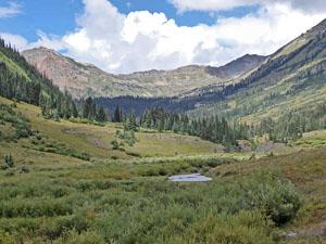
This hike ascends the beautiful Oh Be Joyful valley through wildflower-filled meadows to pretty Blue Lake cradled beneath Purple Mountain and Afley Peak. Along the way views unfold to the panorama of 12,000-ft. peaks ringing the head of the valley.
Oh Be Joyful to Blue Lake
The Oh Be Joyful trail starts from the Oh Be Joyful Camping area off the Slate River Road. (See driving directions.) From the east side of the campground, drive or wade across the Slate River to a trailhead parking area on the west side of the river and turn left (south), following an old mining road past campsites along the river.
Soon the road curves to the right (west), ascending on moderate grades up the north side of the Oh Be Joyful valley through meadows and wooded areas. To the south views open to Mt Emmons (12,392-ft.) and the Gunsight Pass Jeep road climbing through Redwell Basin.
Pass a beautiful waterfall on the Oh Be Joyful creek, running below the left (south) side of the road, at 0.4 miles. This is the first of several pretty falls along the creek.
After walking a little over a mile the trail reaches the trailhead kiosk. In the past it was possible to drive to this point. A short distance beyond a cascade tumbling down an avalanche slope beneath Redwell Basin is visible on the south side of the valley.
Watch for a trail branching to the right off the road at 1.2 miles. This detour circumvents a flood section of the road and boggy meadows.
At 1.5 miles the road gives way to a trail that curves to the right (northwest) as it travels up the valley on easy grades. Cross the boundary into the Raggeds Wilderness at 1.9 miles and then traverse a pretty meadow with views of Peeler Peak (12,227-ft.) rising to the west. On the valley floor a waterfall is seen spilling down rocky ledges along the creek bed. Past the waterfall the trail briefly travels through a wooded area.
Soon the trail emerges from the trees into pretty meadows sprinkled with wildflowers during the height of the summer season. Views extend up the steep-walled “U” shaped valley to Schuylkill Mountain (12,146-ft.) towering above the northeast side of the valley. Beaver Ponds are seen along the creek meandering down the valley floor.
At 3.0 miles views open to head of the valley where Richmond Mountain (12,501-ft.) rises above Democrat Basin to the northwest. The saddle on the ridge is Oh Be Joyful Pass. Soon Hancock (12,410-ft) and Oh-Be-Joyful Peaks (12,420-ft.) join the scene.
At 3.5 miles the trail starts to curve to the left (west). Turn around here for fine views of Mt. Emmons rising to the south. A nice campsite is found in the trees to the south of the trail.
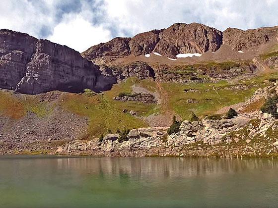
Pass through a metal gate at 3.9 miles. Ahead Afley (12,646-ft.), Oh Be Joyful and Hancock Peaks fill the skyline at the head of the valley. A short distance beyond Purple Peak (12,820-ft.) comes into focus, bookending the head of the valley to the southwest. Blue Lake, the destination for this hike, lies nestled beneath the peak’s northeast face. As you ascend, enjoy ever improving views of the scenic wall of mountains defining the valley’s headwall.
Cross a stream draining the north facing slopes beneath Schuylkill Mountain at 4.4 miles. The trail climbs briefly and reaches a confusing section of the trail at 4.8 miles. Here the trail splits with a track heading right (northwest) and another path branching left (southwest) through willows and crossing a creek. The right branch eventually crosses the creek a little high up and rejoins the main trail a short distance beyond. During high water the upper crossing is probably a little easier. Later in the season it doesn’t matter.
Beyond the crossing the trail enters the woods and starts climbing on moderately-steep grades up the slopes at the head of the valley to a poorly marked junction at 5.4 miles. At the junction a sign labeled “Slate River” points back down the trail. The unmarked trail to the right (north) heads to Democrat Basin and Oh Be Joyful Pass. We turn left (south) toward Blue Lake.
After a short climb the trail curves to the left (south) and ascends on easy grades along a meadow clad bench beneath Little Silver Basin. Rock-hop across Blue Lake’s outlet stream at 5.9 miles and then follow the trail as it climbs steeply through meadows and then trees to a small bench.
After crossing the bench a final steep climb leads to the shelf cradling Blue Lake (11,075-ft.) at 6.6 miles. Purple and Afley Peaks form the backdrop for this beautiful lake, nestled in rocky alpine meadows. The cliffs of the Scarpa Ridge rim the lake basin to the south. Schuylkill Mountain dominates the views to the northeast.
From the lakeshore, look east to see the trail climbing to Star Pass and the Peeler Lake basin beyond. Climbing to the pass is too far for most day hikers. When you are done exploring the lake basin retrace your steps to the trailhead.
Note: The Oh Be Joyful basin is a great option for a short backpack. In addition to Blue Lake, hikers can visit Democratic Basin, Oh Be Joyful Pass and/or Daisy Pass. Good campsites can be found in the trees near the head of Oh Be Joyful valley and in small stands of trees in lovely Democratic Basin.
Elevation Profile
Buy the BookThis opinionated guide includes all the hikes in the Aspen, Buena Vista, Crested Butte, Marble and Leadville sections of the website plus info on local services and nearby attractions. | |

Driving Directions
Driving Directions from Crested Butte: From the intersection of Elk Avenue (main street) and 6th Street in Crested Butte, head north on 6th Street, which turns into the Gothic Road. Follow the Gothic Road (CO 317) for 0.9 miles and turn left (northwest) onto the Slate River Road (CR 734). Drive 4.6 miles and turn left at the Oh Be Joyful Campground. CR 734 is paved for the first 3.6 miles and then turns into a dirt road, which is OK for low clearance, 2WD cars.
Drive down the road to the campground for 0.4 miles to a parking area on the left. The road down to the campground is very rough. Hikers with low clearance vehicles should park off CR 734 near the intersection with the campground road. High clearance vehicle can make it to the parking area near the campground.
During low water it is possible to cross to the west side of the Slate River and park in the trailhead parking lot on the west side of the river. High clearance AWD or 4WD drive is required for the crossing. When in doubt, park on the east side of the river and wade across the river to the start of the hike.
Trail Resources
Trail Intro / Trail Photo Gallery / Trail Map
Basecamp(s) Information:
Crested Butte
Region Information:
Central Colorado
Other Hiking Regions in:
Colorado