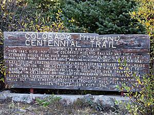
Details: Colorado Midland 
Distance: 6.0 - 7.0 miles (round trip)
White River National Forest, near Leadville in Central Colorado
Hike Facts
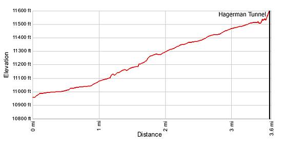
- Distance: 6.0 - 7.0 miles (round trip)
- Elevation: 10,940-ft. - 11,528-ft.
- Elevation Gain: 588-ft. - 588-ft.
- Difficulty: easy-moderate
- Trail Highlights: See Trail Intro
- Basecamp(s): Leadville
- Region: Central Colorado
This hike follows the railroad bed of the first standard gauge line to cross the Continental Divide and ends at the Hagerman Tunnel (11,528-ft.), the highest railroad tunnel in the world at the time it was built in 1887.
Trailhead to the Hagerman Tunnel
On the drive to the Colorado Midland/Hagerman Tunnel trailhead (see driving directions) be sure to stop at Busk-Ivanhoe Tunnel (10,953-ft.), located 3.7-miles up the Hagerman Pass road (one mile before the Colorado Midland trailhead). The tunnel, completed in 1893, is 9,393-ft. long and was built to replace the Hagerman Tunnel, which was too expensive to maintain due to its high elevation.
The Busk-Ivanhoe Tunnel was converted to auto traffic in 1922 and renamed the Carlton Tunnel after the railroad abandoned it. The tunnel remained open to automobile traffic until 1943. Today it is part of the Fryingpan-Arkansas water diversion project, which brings water from Colorado's Western Slope to the Front Range.
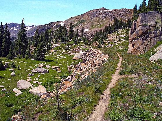
The Colorado Midland/Hagerman Tunnel trail starts on the west side of the Hagerman Pass Road, across from the trailhead parking area (see driving directions). Follow the trail as it heading northwest and then makes a wide arc to the south/southwest. At 1.5 miles reach a ravine where the trail takes a sharp right. This is the site of the former Hagerman Trestle. This curved trestle, 1,100-ft. in length and 84-ft. high, made a wide arc to the northeast to a higher grade that you will reach shortly on the trail.
The trail, which does not follow the route of the trestle, turns right (northeast) onto an old road and climbs to meet the railroad bed at the higher grade. Where the trail meets the grade you have two choices. The first option follows a shortcut trail that crosses the grade and continues on the old road to the ruins of Douglass City, home of the Italian railroad workers who built this part of the line. This city once boasted eight drinking establishments and a dance hall full of "jaded women." It is now one of the more spectacular wildflower areas in this part of the Sawatch Range. Beyond Douglass City the trail climbs to the right (east) of Opal Lake and reaches another segment of the railroad bed just before the Hagerman Tunnel in 0.6 miles.
Alternatively, and my preferred route, is to turn right when you reach the railroad grade and follow the grade to the site of a second trestle that spans a deep cut, reached at 2.5 miles. Slightly before reaching the second trestle site there is a trail that goes left (northwest), bypassing the cut. I recommend continuing along the grade as it curves around to the northwest to meet the bypass trail and then traverses the south side of pretty Hagerman Lake.
Beyond Hagerman Lake the trail passes the sites of 13 snow sheds that protected the rails from snow slides. Scattered pieces of lumber are all that is left of the sheds.
It is only a short distance from the shed sites to the east portal of Hagerman Tunnel (11,528-ft.). As you approach the tunnel views open to Opal Lake, located in a bowl below the trail. Just before the tunnel you will see the spur trail dropping down to the east side of Opal Lake to meet a road. This is the other end of the shortcut trail which passes the Douglass City and ends at a lower segment of the railroad grade.
The Hagerman Tunnel, completed in 1887, is 2,161-ft. long, 16-ft. high and 18-ft. wide and cost $200,000 to build. It was replaced by the Busk Ivanhoe Tunnel in 1891, which you passed on the way to the trailhead. Today the entrance to the Hagerman Tunnel is partially blocked by a rockslide and floor of the tunnel is usually covered by thick ice. It is not safe to enter the tunnel.
For the return trip either retrace your steps (7.0 miles RT) or take the shortcut trail that lead past Opal Lake and the Douglass site. This semi-loop is 6.0 miles RT.
Elevation Profile
Buy the BookThis opinionated guide includes all the hikes in the Aspen, Buena Vista, Crested Butte, Marble and Leadville sections of the website plus info on local services and nearby attractions. | |

Driving Directions
Driving Directions from Leadville: From US 24 in Leadville, turn west on County Road 4/McWethy Drive and drive 3 miles to a three way “Y” intersection. (Paved to left, dirt in the center, paved to right.) Take the paved road to the right at the intersection to stay on County Road 4, following the signs to Turquoise Lake. Further on the road will travel along the south side of the lake.
Toward the head of the lake reach a “Y” intersection (7.4 miles from US 24) and bear left on the Hagerman Pass Road (which becomes Forest Service Road 105) and drive 4.7 miles to the trailhead parking lot, located on the east side of the road. The trail starts on the west side of the road.
Trail Resources
Trail Intro / Trail Photo Gallery / Trail Map
Basecamp(s) Information:
Leadville
Region Information:
Central Colorado
Other Hiking Regions in:
Colorado