Details: Windsor Lake 
Distance: 2.2 miles (round trip)
Mount Massive Wilderness, San Isabel National Forest, near Leadville in Central Colorado
Hike Facts
- Distance: 2.2 miles (round trip)
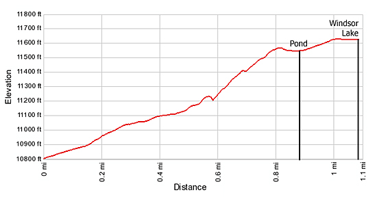
- Elevation: 10,800-ft. - 11,650-ft.
- Elevation Gain: 840-ft. - 850-ft.
- Difficulty: strenuous
- Trail Highlights: See Trail Intro
- Basecamp(s): Leadville
- Region: Central Colorado
This short, strenuous hike visits picturesque Windsor Lake, an alpine jewel cradled beneath the peaks and ridges along the Continental Divide in the Mount Massive Wilderness Area.
Trailhead to Windsor Lake
The Windsor Lake trailhead, located on the west side of the road across from the parking area (see driving directions), immediately crosses an aqueduct on a small dam. The aqueduct is channeled through the Busk Ivanhoe Tunnel, located 100-yards northwest of the trailhead. The tunnel, part of the Fryingpan-Arkansas project, carries water across the Continental Divide from Ivanhoe Lake, on the west side of the divide, to Busk Creek.
Reach the trail register a short distance past the crossing. The open hillside around the register provides nice views of the Continental Divide to the northwest and Galena Mountain to the northeast.
Beyond the register the trail starts its uphill assault, climbing a dry hillside along the north bank of the creek draining Windsor Lake. Soon the path enters the trees and the Mount Massive Wilderness. As you ascend, openings in the trees provide views of the rocky ridge defining the eastern flank of the Continental Divide.
The grade abates a bit as the trail crosses the creek draining Windsor Lake on logs and then quickly resumes the stiff climb on the other side. At 0.5 miles the path begins a very steep ascent of the hillside, gaining 440-ft. in just over 0.3 miles. Slightly before reaching the top of the hill the trail passes an old mine shaft.
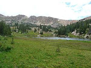
At the top of the hill the trail emerges on a large meadow with a picturesque pond. Views extend west to the granite peaks and ridges along the Continental Divide. The trail stays to the left (south) of the pond, skirting the edge of the forest, and then gently climbs a rocky meadow scattered with conifers to Windsor Lake.
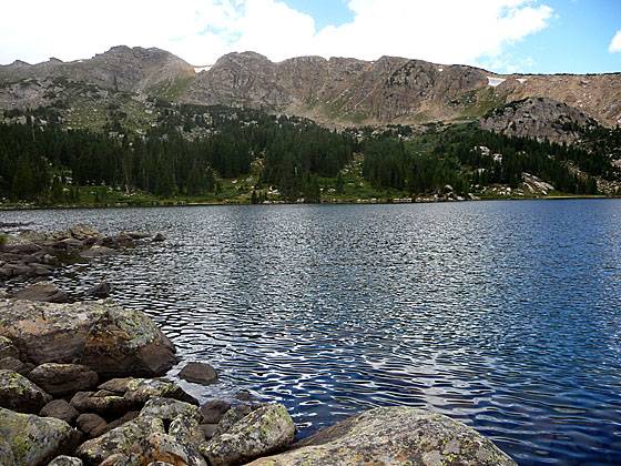
Windsor Lake lies cradled in a large granite basin clad in meadows littered with rock outcroppings and trees. To the west the high peaks and ridges of the Continental Divide command you attention. The rocky shoreline is a favorite with fishermen and the surrounding landscape harbors many nice campsites.
After relaxing by the lake retrace your steps down the steep trail to the trailhead.
Elevation Profile
Buy the BookThis opinionated guide includes all the hikes in the Aspen, Buena Vista, Crested Butte, Marble and Leadville sections of the website plus info on local services and nearby attractions. | |

Driving Directions
Driving Directions from Leadville
From US 24 in Leadville, turn west on County Road 4/McWethy Drive and drive 3 miles to a three way “Y” intersection. (Paved to left, dirt in the center, paved to right.) Take the paved road to the right at the intersection to stay on County Road 4, following the signs to Turquoise Lake. Further on the road will travel along the south side of the lake.
Toward the head of the lake reach a “Y” intersection (7.4 miles from US 24) and bear left on the Hagerman Pass Road (Forest Service Road 105) and drive 3.7 miles to the large trailhead parking lot, located on the right (east) side of the road. The parking area is at the head of a hairpin curve, right before the road turns right (northeast).
Trail Resources
Trail Intro / Trail Photo Gallery / Trail Map
Basecamp(s) Information:
Leadville
Region Information:
Central Colorado
Other Hiking Regions in:
Colorado