Details: Cannibal Plateau 
Distance: 5.0 miles (round trip)
Gunnison National Forest, near Lake City in Southwest Colorado
Hike Facts
- Distance: 5.0 miles (round trip)
- Elevation: 11,050-ft. - 12,360-ft.
- Elevation Gain: 1,900-ft.
- Difficulty: moderate-strenuous
- Trail Highlights: See Trail Intro
- Basecamp(s): Lake City
- Region: Southwest Colorado

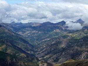
This great half day hike ascending Mesa Seco features splendid views of the San Juan Range rising to the west of the Lake City area along with the Slumgullion Earthflow, a huge, slow-moving landside that broke off the west side of mesa.
Cannibal Plateau
The Cannibal Plateau trail begins on a dirt road off of County Road 50 (see driving directions below). Note this road is open to ATVs, motorcycles and bikes but not jeeps. It is lightly used so you will probably not run into many, if any, vehicles on the trail.
The road ascends on moderate to moderately steep grades through meadows and trees up the southern slopes of Mesa Seco (12,800-ft.). At 0.7 miles the road curves to the right and starts up a switchback. Here a brown post marks a faint path, closed to wheeled vehicles, heading straight up the meadows. This is an old, steep trail that shortcuts the switchbacks. I recommend staying on the road, which climbs on more reasonable grades.
The road now climbs the switchbacks on moderate grades. At 1.1 miles the trail emerges from the trees and views open southwest to the ridge rimming the east side of the Lake Fork of the Gunnison. Bent and Carson Peaks rise above the ridge. Red Mountain dominates the views to the west. As you gain elevation the summits to the north of Henson Creek join the scene.
Nearer-at-hand are views of the multi-hued cliffs of Mesa Seco rising above the Slumgullion Earthflow, a mass wasting that started 700-years ago when a large section of mesa broke away and started sliding down the hill. The slow-moving landslide, which is 4-miles long and covers over 1,000-acres, blocked the Lake Fork of the Gunnison. The resulting natural dam formed Lake San Cristobal. A second earthflow that started 300 years ago is still active and moving at a rate of about 20-ft. per year.
Views continue to expand as you climb. On a clear day Redcloud, Sunshine and Half Peaks soon appear to the distance to the west/southwest.
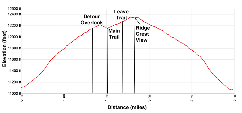
At 1.5 miles the road, now a two-track, crests the mesa as it continues ascending on moderately-easy grades through meadows and clusters of willows. At 1.7 miles the track reaches an intersection with a faint trail branching left. This 0.3 miles round-trip detour leads to an overlook at the edge of the Mesa where the Slumgullion Earthflow broke away from the plateau and slowly slid down the hillside. The gaping maw and the massive tongue of yellow and orange earth extending toward the Lake Fork of the Gunnison is an incredible site. Use caution near the unstable edge.
Beyond the intersection the path travels through meadows with views north to the mesa’s rounded summits. To the southeast Baldy Cinco, Baldy No Es Cinco and several unnamed 13,000-ft. peaks grace the skyline.
At 2.1 miles (2.4 miles including the detour to the overlook) the trail curves to the right and continues ascending the mesa for 3 more miles, well below the ridge marking the western edge of the plateau. You will probably wonder how you are going to see more views if you continue ascending well below the ridge crest.
The answer is to look up and spot three tall rock cairns rising atop the ridge. Leave the trail and start angling up toward the cairns. Stay on the grass as you ascend, skirting patches of rocks and scree.
After walking about 0.2 miles the route crests the ridge and an amazing panorama springs into view. To the northwest a sea of high peaks, including Uncompahgre Peak, Matterhorn Peak and Wetterhorn Peak, fill the skyline. To the west Redcloud, Sunshine and a host of 13,000-ft. peaks rise beyond the aptly named Red Mountain. Lake San Cristobal is seen bellow the mesa at the foot of the Lake Fork of the Gunnison.
On a nice day ascend along the ridge crest enjoying ever evolving views as long as time and energy permit. Alternatively, when you are done enjoying the views, retrace your steps to the road and the trailhead. If you didn’t take the detour to the Slumgullion Overlook on the way up, certain do so on the way down.
Total distance for the shortest up and back hike that includes a trip to the Slumgullion Overlook and a trip to the ridge crest is 5.0 miles (round-trip) with a 1,900-ft. elevation gain.
Note: On the drive back to Lake City stop at Windy Point for views of the Slumgullion Earthflow from a different angle along with more great views of the high peaks rising to the west/northwest. Also, watch for the historic sign pointing to the turn for the Alfred Packer Massacre site, situated beneath Mesa Seco, to learn more about the history of the infamous Lake City cannibal, Alfred Packer.
Elevation Profile
| Buy the BookThis opinionated guide includes all the hikes in the Ouray, Telluride, Silverton and Lake City sections of the website plus info on local services and nearby attractions. |
Driving Directions
Driving Directions from Lake City: From the Lake City Tourist Information Center at the junction of Gunnison Avenue (Main Street) and Gunnison Street, follow Colorado 149 South for 10 miles and then turn left onto County Road 50. Drive 0.1 miles on CR 50 to the signed Cannibal Plateau trailhead on the left side of the road. There are several spots to pull off the road and park near the trailhead.
Trail Resources
Trail Intro / Trail Photo Gallery / Trail Map
Basecamp(s) Information:
Lake City
Region Information:
Southwest Colorado
Other Hiking Regions in:
Colorado