Details: Crystal Lake 
Distance: 8.2 miles (round trip)
Uncompahgre National Forest, near Lake City in Southwest Colorado
Hike Facts
- Distance: 8.2 miles (round trip)
- Elevation: 8,875-ft. - 11,760-ft.
- Elevation Gain: 2,885-ft.
- Difficulty: moderate-strenuous
- Trail Highlights: See Trail Intro
- Basecamp(s): Lake City
- Region: Southwest Colorado
A stiff ascent through aspen groves, forest and meadows leads to pretty Crystal Lake set against the eastern slopes of Crystal Peak. Fine views encompass the vast tundra-clad plateaus to the east and the high peaks towering above Henson Creek to the south.
Trailhead to Crystal Lake
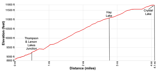
The trailhead for the Crystal and Larson Lake trails is located near the Lake City IOOF Cemetery (see driving directions below). From the parking area ascend through pine and aspen trees along Balsam Drive, now a dirt road, for 0.5 miles to a forest service gate and a signed trail junction. Here we bear left (west) on the Crystal Lake Trail. The trail to the right leads to Thompson and Larson Lakes.
The trail ascends on moderately-steep/steep grades, generally heading west through aspens and pines along an old jeep road. Soon the trees give way to meadows and the trail leaves the road as its climbs switchbacks along the north slopes above Slaughterhouse Gulch. From the meadows enjoy views of Lake City to the south/southeast and Mesa Seco, (12,800-ft.) rising across the valley to the east.
At 1.5 miles the trail enters a beautiful aspen grove. The steady ascent continues through aspens interspersed with small meadows. At 2.5 miles the trail leaves the Slaughterhouse drainage and ascends across a bench, skirting the north side of an old rockslide set amid spruce, fir and aspens trees. Views open east/southeast to the tundra-clad plateaus and peaks rising above Highway 149.
Reach the southern shore of tiny, timber-lined Hay Lake at 2.75 miles. The rocky trail now swings to the southwest and travels through trees, reaching a second rockslide at 3.1 miles. Here the trail swings to the right (west), ascending along the base of the slide before curving to the right (northwest).
After a short climb, the grade abates at 3.3 miles as the trail traverses through scattered trees along an irrigation ditch, high above the east side of Crystal Creek. Openings offer ever improving views of the Redcloud Peak massif and the high peaks towering above Alpine Gulch to the south.
At 3.8 miles the trail curves to the right (north/northwest) as it climbs on moderate grades to a high basin. The grade ease as the trail crests the basin and enters beautiful meadows with stunning views of Red Mountain (12,826-ft.), Grassy Mountain (12,821-ft.), the Redcloud massif (14,034-ft.) and the unnamed peaks soaring above Alpine and Owl Gulches to the south of Henson Creek. Crystal Peak (12,933-ft.) towers above the basin to the west.
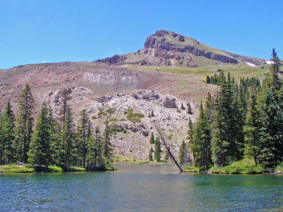
Cross the meadow, reenter the trees and then reach the east shore of Crystal Lake (11,700-ft.) at 4.1 miles. The pretty lake, nestled beneath the eastern slopes of Crystal Peak, features a small, wooded island. Nearby are the ruins of an old cabin.
Posts and cairns in the meadows beyond the lake mark the continuation of the trail to Larson Lake, a destination best done as a backpack. The area around Crystal Lake invites exploration. Hikers with the time and energy can climb to the summit of Crystal Peak, which will add 1,170-ft. and 2 miles (round-trip) to the hike.
When you are done enjoying the lake, retrace your steps to the trailhead for an 8.2 miles round-trip hike.
Elevation Profile
| Buy the BookThis opinionated guide includes all the hikes in the Ouray, Telluride, Silverton and Lake City sections of the website plus info on local services and nearby attractions. |
Driving Directions
From Lake City: From Gunnison Ave/ Highway 149 and 4th Street in Lake City, head north on Gunnison Ave/Highway 149 N for 0.9 miles and turn left onto Balsam Drive, signed for the Lake City IOOF Cemetery. Follow Balsam Drive for 0.3 miles to a parking area just past the cemetery, signed for the Crystal Lake/Larson Lakes trailhead.
Trail Resources
Trail Intro / Trail Photo Gallery / Trail Map
Basecamp(s) Information:
Lake City
Region Information:
Southwest Colorado
Other Hiking Regions in:
Colorado