Details: Powderhorn Lake 
Distance: 7.8 - 9.6 miles (round trip)
Powderhorn Wilderness, Gunnison BLM, near Lake City in Southwest Colorado
Hike Facts
- Distance: 7.8 - 9.6 miles (round trip)
- Elevation: 11,140-ft. - 11,870-ft.
- Elevation Gain: 1,050-ft.
- Difficulty: moderate
- Trail Highlights: See Trail Intro
- Basecamp(s): Lake City
- Region: Southwest Colorado
An interesting hike through forest and meadows to a scenic lake basin nestled beneath the eastern escarpment of the Calf Creek Plateau (12,644-ft.) in the Powderhorn Wilderness.
Trailhead to Powderhorn Lakes
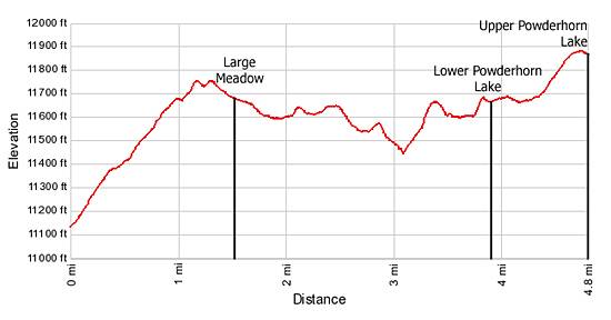
The path to the Powderhorn Lakes climbs southwest through a forest of Engelmann spruce along the eastern side of a long valley. At the head of the valley the trail crest a ridge and then drops into a large, scenic, wildflower-filled meadow at 1.5 miles. If you're lucky you may see elk grazing in the meadow in the early morning or late evening. Take a short side trip to the meadow’s western rim for nice views to the northwest.
The trail descends gently across the meadow and then skirts its southwestern edge before reentering the trees at 1.9 miles. The trail, now in the West Fork of Powderhorn drainage, follows a rolling traverse, crossing a low ridge before dropping into minor drainage with a small lake set amid meadows filled with willows.
Beyond the lake the trail returns to the trees, climbs a small rise and then loses 130-ft. in 0.2 miles. At the bottom of the drop the path turns southwest, paralleling the unseen West Fork of Powderhorn Creek. Another short, moderately steep climb leads to the top of a small hill at 3.4 miles and the junction with the trail to Hidden Lake, heading west.
From the junction the path descends to and skirts the marshy meadows along the north side of the creek, passing several beaver ponds along the way, and arrives at a trail junction with a sign pointing straight ahead to the Powderhorn Lakes. (The unsigned trail to the left is the Middle Fork Trail that climbs to the Calf Creek Plateau.)
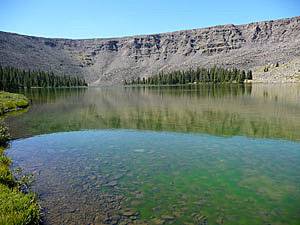
Soon after the junction the trail ascends a small rise and arrives at Lower Powderhorn Lake at 3.9 miles. The lake sits at the eastern end of a large cirque. The cirque’s steep rocky walls rise over 440-ft. above the lake to the Calf Creek Plateau.
To reach Upper Powderhorn Lake follow the trail as it skirts marshy meadows around the right (northwest) side of the lake. At the end of the lake the trail climbs a hillside through forest and meadows to the upper lake basin, gaining a little over 200-ft. in 0.6 miles.
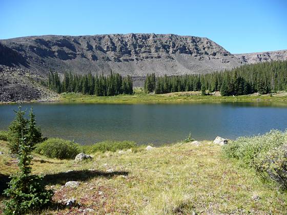
Reach Upper Powderhorn Lake at 4.8 miles. The lake lies cradled in a glacier-carved bowl beneath the eastern escarpment of the Calf Creek Plateau. Steep volcanic rock walls rise 500-ft. to 700-ft. from the southern and western shoreline of the large lake to the plateau. Good campsites are located on the north and eastern sides of the lake.
The Powderhorn Lakes Trail can be used in conjunction with the East Fork Trail, the Middle Fork Trail and the Powderhorn Park Trail for a nice backpacking trip.
The Lower Powderhorn Lake provides fair to good trout fishing as do the stream and beaver ponds of the West Fork of Powderhorn Creek. The Upper Powderhorn Lake sometimes has fish and sometimes suffers from winter kill.
Elevation Profile
| Buy the BookThis opinionated guide includes all the hikes in the Ouray, Telluride, Silverton and Lake City sections of the website plus info on local services and nearby attractions. |
Driving Directions
Driving Directions From Lake City: Drive north on Hwy 149 for just over 24 miles and turn right on Indian Creek Road / County Road 58. Follow the rough 2-wheel drive road for 10 miles. The trailhead sign and parking area are at the end of the road.
Driving Directions From Gunnison: Go 9 miles west on Hwy. 50 to Hwy.149 and turn left. Follow Hwy. 149 south for 20 miles. Turn left on Indian Creek Road (County Rd. 58) and follow the rough 2-wheel drive road for 10 miles. The trailhead sign and parking area are at the end of the road.
Trail Resources
Trail Intro / Trail Photo Gallery / Trail Map
Basecamp(s) Information:
Lake City
Region Information:
Southwest Colorado
Other Hiking Regions in:
Colorado