Details: Uncompahgre Peak 
Distance: 7.8 miles (round trip)
Uncompahgre Wilderness, Uncompahgre National Forest, near Lake City in Southwest Colorado
Hike Facts
- Distance: 7.8 miles (round trip)
- Elevation: 11,430-ft. - 14,309-ft.
- Elevation Gain: 2,879-ft.
- Difficulty: strenuous-difficult
- Trail Highlights: See Trail Intro
- Basecamp(s): Lake City
- Region: Southwest Colorado
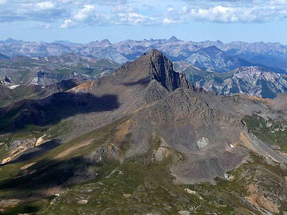
Stunning panoramic views are the rewards for hiking to the top Uncompahgre Peak (14,309-ft.), the sixth highest fourteener in Colorado and the highest point in the San Juan Mountains.
Trailhead to Uncompahgre Peak
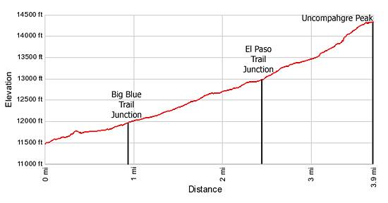
The trail starts at the northeast end of the trailhead parking area (see driving directions below) and ascends northwest on moderate grades through meadows and spruce-fir forest, staying to the right (northeast) of Nellie Creek. At 0.6 miles the trail leaves the last of the trees behind and enters a rocky gully where it climbs switchbacks up the gully’s north wall to a trail junction with the Big Blue trail at 0.9 miles.
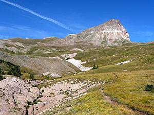
At the junction the Big Blue trail heads right (north). We turn left (west) on the trail to Uncompahgre Peak. Ahead are stunning, unobstructed views of Uncompahgre’s east face and distinctive summit block, which from this angle looks somewhat like a huge lopsided wedding cake.
Follow the trail as it traverses along the top of the gully’s north wall. In a short distance you will see Nellie Creek tumbling down a rocky cleft in the wall. At this point the trail starts curving northwest, climbing through the pretty meadows with ever improving views of Uncompahgre Peak. Vistas to the south extend to the peaks rising above the Henson Creek Valley.
At 2.0 miles the trail swings south, heading toward the southern end of the basin. Reach a junction (12,940-ft.) at 2.4 miles. Here the the El Paso Trail branches left (southeast) toward Matterhorn Creek. Bear right at the junction to stay on the Uncompahgre trail. From this point you still have 1.5 miles and a 1,370-ft. climb to the summit.
Beyond the junction the trail makes a wide arc to the northwest, heading toward the Uncompahgre’s south ridge and then ascends steeply along the east side of the south ridge.
At 3.1 miles a low point in the ridge provides interesting, albeit restricted views of Matterhorn Peak to the west. Past the viewpoint the trail climbs steep switchbacks up a rocky east facing hillside to the crest of the south ridge (13,860-ft.) at 3.4 miles. At the crest take a breather and enjoy the wonderful views of Matterhorn and Wetterhorn Peaks, Courthouse Mountain and the other summits rising to the west.
The trail now crosses to the west side of the ridge for a short traverse along a narrow, rocky trail with enough exposure to make some people uncomfortable. Next comes to the most difficult part of the hike, a 125-ft. scramble up a steep eroded slope of loose rock. There are several routes climbing the slope. Pick the way that looks best to you and scramble to the top of the ridge.
At the top of the ridge be sure to turn around and note where you ascended the ridge so you can find your way back down on the return. There should be rock cairns marking the best place to descend.
Once atop the ridge the going is much easier. Follow the trail as heads north/northeast, climbing 340-ft. up a steep scree covered slope to the large plateau at the top of the peak.
Uncompahgre Peak stands apart from its surrounding summits, providing breathtaking vistas in all directions. Expansive views to the west encompass Matterhorn and Wetterhorn Peaks and, in the distance, the summits of the Mt. Sneffels Wilderness. To the north/northwest are the peaks and valleys of the Uncompahgre Wilderness. To the south/southwest the peaks and ridges of the San Juan Mountains fill the skyline.
When you are done soaking in the views, reverse course and enjoy the scenic hike back to the trailhead.
At the top remember to keep an eye on the weather. If thunderstorms are building it is best to descend and head back to the trailhead.
Elevation Profile
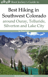
| Buy the BookThis opinionated guide includes all the hikes in the Ouray, Telluride, Silverton and Lake City sections of the website plus info on local services and nearby attractions. |
Driving Directions
Driving Directions from Lake City: Head west on Second Street and then turn left onto the Henson Creek Road, part of the Alpine Loop Scenic Byway. Follow Henson Creek Road for 4.0 miles to the Nellie Creek jeep road. Turn right (north) on the Nellie Creek Road and drive this nasty, rocky and narrow 4WD road for 4.0 miles to the trailhead. The road crosses Nellie Creek twice on its way to the trailhead. High clearance is required. Do not even think about taking a passenger car on this road.
Walking up the Nellie Creek road will add 8 miles (RT) and 2,115-ft. to the climb, making this a 15.8 mile (RT) hike with an elevation gain just under 5,000-ft.
Trail Resources
Trail Intro / Trail Photo Gallery / Trail Map
Basecamp(s) Information:
Lake City
Region Information:
Southwest Colorado
Other Hiking Regions in:
Colorado