Details: Blue Lakes and Blue Lakes Pass 
Distance: 6.3 - 11.0 miles (round trip)
Mt. Sneffels Wilderness Area, Uncompahgre National Forest, near Ouray in Southwest Colorado
Hike Facts
- Distance: 6.3 - 11.0 miles (round trip)
- Elevation: 9,350-ft. - 13,000-ft.
- Elevation Gain: 1,590-ft. - 3,650-ft.
- Difficulty: moderate-strenuous
- Trail Highlights: See Trail Intro
- Basecamp(s): Ouray
- Region: Southwest Colorado
This popular hike visits three scenic lakes nestled in beautiful glacial basins set amid rugged ridges and peaks. Beyond the lakes the trail climbs to a dramatic pass on a ridge south of Mt. Sneffels (14,150-ft).
Trailhead to Lower Blue Lakes
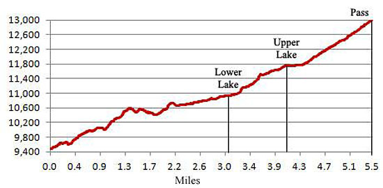
Distance from Trailhead: 6.3 miles (round trip)
Ending/Highest Elevation: 10,940-ft.
Elevation Gain: 1,590-ft.
The Blue Lakes trail starts at the north end of the trailhead parking lot (see driving directions below), passes through a gate and soon reaches a signed “Y” intersection. Here the trail branches right and ascends on moderate grades through a forest of Engelmann spruce and pines along the right (west) of East Fork Dallas Creek. (The trail to the left leads to Blaine Basin.) Occasional openings in the trees provide tantalizing views of surrounding peaks.
At 1.4 miles the grade moderates and the path soon begins passing through intermittent meadows with vistas of the rugged peaks lining the lower basin. After crossing a creek at 1.8 miles the grade steepens and the trail crosses an avalanche chute with views of Mt. Sneffels to the east. You'll know when you are less than 1/3 of a mile from the lower lake when you see a waterfall tumbling down a rocky cleft on your left (southeast).
Past the waterfall the trail climbs on moderately steep grades to a signed junction with a short spur trail leading straight ahead (south) to Lower Blue Lake. The trail branching to the left (east) continues to the upper lakes. Acclimated hikers will reach this point in about 1 1/2 hours (3.2 miles, 1,500-ft. elevation gain).
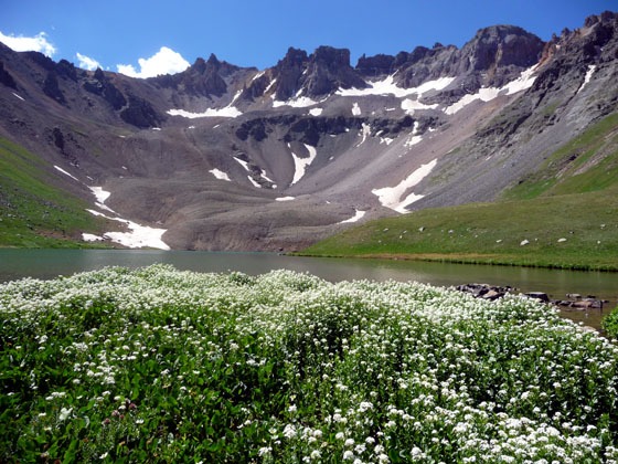
Pretty Lower Blue Lake (10,940-ft.) lies nestled in a scenic bowl beneath a cirque of jagged peaks dominated by Dallas Peak (13,809-ft.) to the southwest. Mount Sneffels (14,156-ft.) rises to the east. Steep scree slopes spill down the cirque's rugged walls to the southern and western shoreline of the lake. Nice campsites, sheltered by trees, are located on the lake’s north and northwest shore.
Lower Blue Lakes to Upper Blue Lakes
Distance from Trailhead: 8.2 miles (round trip)
Ending/Highest Elevation: 11,750-ft.
Elevation Gain: 2,400-ft.
To reach the upper lakes return to the junction and turn east. Drop down to the East Fork of Dallas Creek and find a place to cross. Several large logs and rocks will help keep your feet dry. The continuation of the trail is on the left (north) side of the creek draining the upper lakes. Finding the trail on the other side of the creek can be little confusing due to erosion and use trails leading to more campsites.
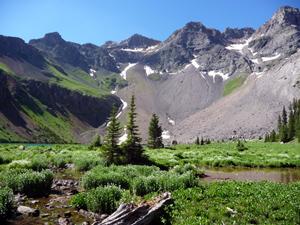
The path now climbs steeply up the headwall of the lower basin, en route crossing back to the west side of the creek. As you climb trees give way to alpine tundra sprinkled with wildflowers in mid-July to early August. At the top of the headwall the trail reaches a fantastic viewpoint showcasing the lower lake basin.
Beyond the viewpoint the climb moderates as the trail passes to the west and above middle Blue Lake, reaching Upper Blue Lake after 0.9 miles and a 700-ft. elevation gain. (Total hiking distance: 4.1 miles / 2,350-ft. of elevation gain.)
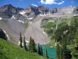
The upper lake is set amid meadows dotted with wildflowers. A scenic ridge with steep scree slopes tinted bronze, rust and gold extends from Dallas Peak to Gilpin Peak (13,694-ft.), forming the southern wall of the upper basin. The ridge between Gilpin Peak and Mt Sneffels creates the eastern wall.
While the upper basin is a great destination and the perfect place to relax and take in the scenery, hikers with the time (and good weather) will want to climb to Blue Lakes Pass (13,000-ft). The pass is situated 1,250-ft. above the upper Lake on the ridge extending between Mt. Sneffels and Gilpin Peak.
Upper Lakes to Blue Lakes Pass
Distance from Trailhead: 11.0 miles (round trip)
Ending/Highest Elevation: 13,000-ft.
Elevation Gain: 3,650-ft.
To reach the pass follow the well-defined trail around the left (east) side of Upper Blue Lake to a series of long, steep switchbacks. As you ascend fields of wildflowers give way to dirt and talus. Footing is generally good except for a few eroded sections with some exposure.
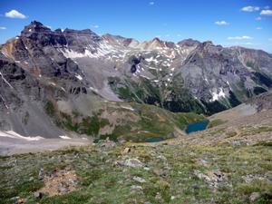
Take occasional breaks from the climb to admire the wonderful views of the jagged ridge towering above the sapphire blue lakes of the upper basin. Reach the top of the pass in 1.4 miles (total distance: 5.5 miles with 3,650-ft. of elevation gain from the trailhead).
The pass offers splendid views of the peaks and ridges defining the Blue Lakes basin. To the south is Yankee Boy Basin dominated by Gilpin Peak (13,694-ft.), Potosi (13,786-ft.) and Teakettle Mountain (13,819-ft.). In the distance a series of peaks and ridges form the northern wall of Yankee Boy Basin.
On the north side of the pass a faint trail marks the start of a Class 3 route climbing Mt. Sneffel’s southwest ridge. (see: Summit Post Mt. Sneffels for more information on climbing Mt. Sneffels.) This route should only be used by parties with prior climbing experience. Most people climb Mt. Sneffles (14,156-ft.) from a well-defined Class 2 route that begins in Yankee Boy basin.
Once you are done soaking in the scenery retrace your steps to the trailhead. Parties with a pre-positioned second vehicle can continue over the pass and down to a 4WD road in Yankee Boy Basin (1.4 miles).
Note: This is a popular trail that is best hiked on a weekday if you wish to encounter fewer people on the trail.
Elevation Profile
| Buy the BookThis opinionated guide includes all the hikes in the Ouray, Telluride, Silverton and Lake City sections of the website plus info on local services and nearby attractions. |
Driving Directions
Driving directions from Ouray: It takes 45-50 minutes to drive the 24 miles from Ouray to the Blue Lakes trailhead. The drive is quite scenic with views dominated by 14,150-ft. Mt. Sneffels and its neighboring peaks and ridgelines, almost all over 13,000-ft.
From the center of Ouray take Highway 550 heading north for just over 10 miles to Highway 62 in Ridgway. Turn left (west) on Highway 62. Drive 4.8 miles and then take a left onto County Road 7,marked Dallas Creek (the road use to be marked East Dallas Creek). It is easy to miss the turn while you are admiring the scenery to the south of the highway. In two miles CR-7 bears right where it meets CR-7A. Continue for a total of 9 miles on CR-7 through a beautiful valley to the parking area at the trailhead. Note: CR-7 turns into Forest Road 851.1 at the forest boundary.
Driving Directions from Telluride: From Telluride the trailhead is a 90 minute/44 miles drive. Drive west on West Colorado Avenue to Highway 145. Head west on Hwy 145 for 12.7 miles to where it dead ends at Highway 62 in Placerville. Turn right (east) onto Highway 62 and drive 18.6 miles to County Road 7, marked Dallas Creek. Turn right onto CR-7. In two miles CR-7 bears right where it meets CR-7A. Continue for a total of 9 miles through a beautiful valley to the parking area at the trailhead. Note: CR-7 turns into Forest Road 851.1 at the forest boundary.
Road Conditions: Passenger car accessible if driven carefully. CR-7 is a dirt/gravel road that becomes rougher as it climbs to the National Forest boundary. Beyond this point the road maintenance deteriorates and you will need to dodge potholes and rocks.
Trail Resources
Trail Intro / Trail Photo Gallery / Trail Map
Basecamp(s) Information:
Ouray
Region Information:
Southwest Colorado
Other Hiking Regions in:
Colorado