Details: Spirit Gulch 
Distance: 5.2 - 7.0 miles (round trip)
Uncompahgre National Forest, near Ouray in Southwest Colorado
By: Diane Greer
Hike Facts
- Distance: 5.2 - 7.0 miles (round trip)
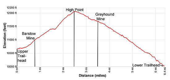
- Elevation: 10,670-ft. - 12,040-ft.
- Elevation Gain: 1,370-ft.
- Difficulty: moderate
- Trail Highlights: See Trail Intro
- Basecamp(s): Ouray / Silverton
- Region: Southwest Colorado
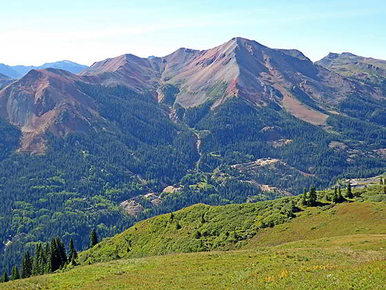
This pretty trail travels along an old mining road through three wildflower-filled basins accompanied by grand views of the Red Mountains towering above the west side of the Million Dollar Highway. Ruins of the Barstow and Greyhound mines add interest to the walk.
Spirit Gulch
The Spirit Gulch trail starts at an old mining road, blocked by a green metal gate, to the south of the Red Mountain Mining District Overlook. (See driving directions below.)
Walk through an opening to the left of the green gate and then follow a short trail leading to the dirt/gravel road. The old mining road, now closed to vehicles, heads north/northwest through trees, crossing the creek draining Commodore Gulch at 0.3 miles. Beyond the creek the trail ascends on easy to moderate grades through trees and small meadows, crossing a second creek at 0.5 miles. Openings in the trees offer glimpses of the peaks rising above Commodore Gulch to the northwest and the Red Mountain area across the valley to the east.
The grade steepens as the trail curves to the west, reaching the ruins of the Barstow Mine at 0.8 miles. Rugged granite peaks rimming the west side of Commodore Gulch form the scenic backdrop the mine, which produced silver, copper and fluorite.
At the mine the trail curves to the right and then left as it climbs above the tailings piles. Past the mine the two-track road curves to the right, ascending a switchback through meadows scattered with trees. During the height of the summer wildflowers cover the hillsides. As you climb enjoy every improving views east of the Red Mountains. Ruins of mining structures and a network of old mining roads fill the valley floor.
The road crosses a ridge at 1.3 miles and enters Spirit Gulch. Soon the grade abates and lovely views open up the length of the beautiful basin clad in lush meadows sporting a profusion of wildflowers. Peaks T7 (13,359-ft.) and T8 (13,359-ft.) soar above the head of the basin.
The path now crosses two minor streams and then the main creek draining Spirit Gulch at 1.6 miles. On the other side of the creek the two-track soon curves to the left, ascending the east side of the basin on a diagonal with moderate to moderately-steep grades. Behind you (to the southeast) are fine views of Red Mountain Number 3, Mc Millan Peak and Ohio Peak. Ahead, Peak T7 towers above the west side of Spirit Gulch. Rugged crags rim the ridge at the head of the valley.
At 2.2 miles the trail turns to the right (east/southeast) on a switchback. Ignore the faint track continuing straight ahead. This old road dead-ends at a tailing pile beneath an old mine.
The path now ascends on moderate grades to a junction and the high point of the trail at 2.5 miles. Take the lower path (right fork) that soon curves around the head of a ridge. Beneath the trail are the scars of a landslide stretching down Governor Gulch. To the east are great views of the Red Mountains. To the south vistas extend down the Million Dollar Highway to Bear Mountain and the summits of Grand Turk and Sultan Mountain.
This is a good turn around point for parties looking for a shorter hike. If time and energy permit, I recommend continuing the hike to the viewpoint above McIntyre Gulch.
Past the viewpoint the trail descends gentle through beautiful meadows with terrific views of the Red Mountains. Peak 13,150 rises above the path to the north. To the south, views expand to encompass the Twin Sisters. Along the way the path crosses a few small slides coming down the slopes above the trail.
At 3.1 miles the trail curves arounds a ridge and reaches an overlook above McIntyre Gulch. On a clear day views extends northeast to Darley Mountain, Abrams Mountain, Wildhorse Peak and Wetterhorn Peak (14,015-ft.). Across the valley are more great views of the Red Mountains and the peaks rising to the south. The tailings and disturbed area along the floor of the gulch mark the site of the Greyhound Mine.
This is a good turn around point for people who are doing the hike as an out-and-back. Hikers interested in mining history will want to continue to the Greyhound Mine. The continuation of the trail descends on easy grades to the mine at 3.5 miles. Old rail track, some rusted mine equipment and a door blocking the opening for the mine are visible from the trail.
Hikers with a previously arranged car shuttle can continue the hike down McIntyre Gulch. Beyond the mine the old road descends through meadows along the west side of the Gulch, entering the trees at 3.9 miles. As the path switchbacks down the slopes between McIntyre and Galena Lion Gulches the trees thicken and we lose the views. This final leg of the hike reaches Highway 550 at 6.4 miles. Elevation loss for the shuttle is 2,010-ft.
This end point is located 2.4 miles north of the trailhead. I don’t recommend walking back along Highway 550 to reach the starting point for the hike. Highway 50 is a narrow, twisting road with a lot of traffic during the summer. Instead simply turning around at one of the viewpoints or the Greyhound Mine and retrace your steps to the trailhead, enjoying the views and wildflowers on the return leg of the hike. This is a more scenic option than walking down through forest to the road.
Elevation Profile
| Buy the BookThis opinionated guide includes all the hikes in the Ouray, Telluride, Silverton and Lake City sections of the website plus info on local services and nearby attractions. |
Driving Directions
Driving Directions from Ouray: From the center of Ouray (6th Avenue and Main Street), head south on Highway 550-S for 11.4 miles. Park by the green gate blocking a jeep road, located on the right side of Highway 550. The gate is located at the first switchback after passing the Red Mountain Mining District Overlook (across from the shuttered Idarado Mine Complex at 11.3 miles), between mile marker 82 and 83.
Please be considerate and do not block the gate. Also make sure you leave room for other cars to park. If no parking is available near the gate, park at the Overlook and walk down to the gate.
Driving Directions from Silverton: From the intersection of Highway 550 and the turnoff to Silverton (110), drive 11.4 miles north on Highway 550. Park by the green gate blocking a jeep road, located on the left side of Highway 550. Highway 550 will cross Red Mountain Pass at 9.9 miles. The gate is located 1.6 miles beyond the pass on the left side of the road. (If you pass mile marker 82 you have gone too far.)
Please be considerate and do not block the gate. Also make sure you leave room for other cars to park. If no parking is available near the gate, drive 0.1 miles north and turn left into the Red Mountain Mining District Overlook (across from the shuttered Idarado Mine Complex) at 11.5 miles. Park at the Overlook and walk back to the gate.
Trail Resources
Trail Intro / Trail Photo Gallery / Trail Map
Basecamp(s) Information:
Ouray / Silverton
Region Information:
Southwest Colorado
Other Hiking Regions in:
Colorado