Details: Colorado Trail: Little Molas Lake to Lime Creek 
Distance: 7.4 - 10.1 miles (round trip)
San Juan National Forest, near Silverton in Southwest Colorado
Hike Facts
- Distance: 7.4 - 10.1 miles (round trip)
- Elevation: 10,895-ft. - 11,650-ft.
- Elevation Gain: 755-ft.
- Difficulty: moderate
- Trail Highlights: See Trail Intro
- Basecamp(s): Silverton / Ouray
- Region: Southwest Colorado
A moderately easy hike along a segment of the Colorado Trail featuring panoramic views from the high meadows above the West Lime Creek valley.
Trailhead to Lime Creek Drainage
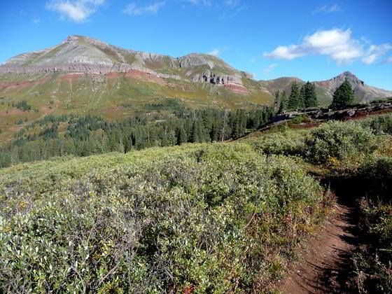
From the trailhead at the western end of Little Molas Lake (see driving directions), follow the Colorado Trail as it heads northwest climbing limestone terraces on switchbacks with moderately easy grades. Along the way pass through pockets of trees and open meadows with views south to Engineer Peak (12,698-ft.) and North Twilight Peak (13,075-ft.).
After gaining 390-ft. in 1.3 miles the trail turns right (northeast) and joins a wide dirt track near the top of a ridge. The eroded track ascends to and traverses the ridge towards West Turkshead Peak (12,849-ft.). Here views open west to the Twin Sisters (13,432 and 13,374-ft.) and Jura Knob (12,592-ft.). Snowden Peak and the Grenadier Range fill the skyline to the east.
Follow the track uphill for 0.7 miles. The trail narrows and turns left (northwest) as it nears West Turkshead Peak, two miles from the start of the hike.
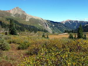
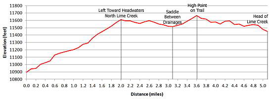
The trail now traverses the east side of the North Lime Creek drainage. Toward the head of the drainage the path descends to and crosses a saddle at 3.1 miles, located between the Bear Creek valley (to the north) and the North Lime Creek valley (to the south). Views at the saddle extend north to Bear Mountain (12,987-ft.) and Sultan Mountain (13,368-ft.).
From the saddle the trail heads west, ascending to the high point of the hike (11,650-ft.) at 3.6-miles and then loses 100-ft. over 0.4 miles as it crosses and curves around the ridge separating the North Lime Creek and Lime Creek drainages. Below the trail two tarns lie nestled on the ridge’s broad shoulder.
Continue walking until the trail starts to drop towards the head of Lime Creek on switchbacks at 5.0 miles. This is a good place to turn around.
From this vantage point panoramic views encompass Twin Sisters, Jura Knob, Engineer Mountain, North Twilight Peak, the Snowden Mountains and the Grenadier Range. After taking a break and soaking in the scenery, retrace your steps enjoying the views on the return leg.
Note: Mountain bikes are permitted on this trail.
Elevation Profile
| Buy the BookThis opinionated guide includes all the hikes in the Ouray, Telluride, Silverton and Lake City sections of the website plus info on local services and nearby attractions. |

Driving Directions
Driving directions from Ouray: Go 5.5 miles south of Silverton (27 miles south of Ouray, 44.5 miles north of Durango) on US 550 and turn west on Little Molas Lake Road. The Molas Lake Road is 0.4 miles north of Molas Pass. Follow the road for 0.8 miles to the parking area beyond the lake. The Colorado Trail trailhead is located at the northwest end of the parking area.
Trail Resources
Trail Intro / Trail Photo Gallery / Trail Map
Basecamp(s) Information:
Silverton / Ouray
Region Information:
Southwest Colorado
Other Hiking Regions in:
Colorado