Details: Minnie Gulch 
Distance: 5.1 - 6.3 miles (round trip)
San Juan National Forest, near Silverton in Southwest Colorado
Hike Facts
- Distance: 5.1 - 6.3 miles (round trip)
- Elevation: 11,600-ft. - 12,960-ft.
- Elevation Gain: 1,670-ft.
- Difficulty: moderate-strenuous
- Trail Highlights: See Trail Intro
- Basecamp(s): Silverton
- Region: Southwest Colorado
Alpine meadows, far-reaching views and solitude are the hallmarks of this scenic trail that ascends Minnie Gulch to the Continental Divide Trail (CDT) and then follows the CDT in either direction (or both) accompanied by amazing, panoramic views. The hike can easily be shorten or extended.
Minnie Gulch
Note: The trailhead for this hike is at the end of a 4WD road that requires a vehicle with good clearance. (Don’t even think about taking a 2WD passenger vehicle on this road.) This is one of the easier 4WD roads in the Silverton area. Check on current road conditions at the Silverton Visitor Center before setting out.
This trail begins at the pullout/parking area near the end of the Minnie Gulch Road. (See driving directions below.) Follow the trail as it ascends south/southeast on moderate to moderately-steep grades through meadows along the east side of Minnie Gulch. As you climb enjoy views of the rugged ridges rimming the valley. Behind you are ever improving vistas of the summits at the foot of the valley and the peaks rising to the west of the Alpine Pass Road. Wildflowers adorn the valley floor during the height of the summer.
Near the head of the valley the trail fades. Look left (southeast) for cairns marking the route that swings away from the valley floor to avoid some rock outcroppings. If you lose the trail simply continue up the valley, aiming for the obvious saddle.
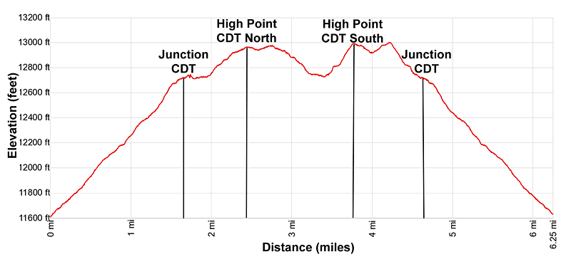
Reach a junction and the end of the Minnie Gulch trail at 1.7 miles. Here the Continental Divide Trail (CDT)/Colorado Trail (CT) head left (north) and right (south) while the Middle Fork Pole Creek trail continues straight toward a saddle. I recommend taking a quick detour along the Middle Fork Trail to the saddle where views open east/southeast to the peaks rising above the Pole Creek Valley. On a clear day vistas extend to the Rio Grande Pyramid and the Window in the Weminuche Wilderness.
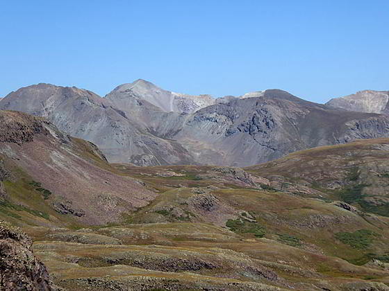
After taking in the views return to the trail junction and turn right (north) on the combined CDT/CT. The trail now ascends on easy to moderate grades through rocky meadows and small patches of scree to the high point on the ridge at 2.4 miles. The ascent is accompanied by fine views down the length of Minnie Gulch. To the west/southwest views extend to Galena Mountain along with the summits rimming Maggie Gulch and Cunningham Creek. To the west are the high peaks rising above the Alpine Pass Road and beyond.
I recommend continuing past the high point on the ridge to an overlook above Cuba Gulch at 2.6 miles. From this vantage point enjoy spectacular views of the peaks towering above Cuba Gulch, Cottonwood Creek and the Lake Fork of the Gunnison River. On a clear day you should be able to pick out Sunshine (14,001-ft.) and Redcloud (14,034-ft.) Peaks to the northeast and Handies Peak (14,048-ft.) rising to the north. Crown Mountain, Niagara Peak and Jones Mountain dominate the view above the ridgeline to the northwest. A small pond lies cradled in the alpine meadows to the west.
It is possible to extend the hike by leaving the CDT and following a trail the skirts the north side of the pond. The trail heads northwest through an undulating landscape atop a high plateau above the east side of Minnie Gulch, following the boundary line dividing San Juan and Hinsdale counties. The trail eventually drops down to the Kitti Mack Mine complex. This trail is only recommended for experienced hikers carrying the appropriate maps.
I recommend turning around at the overlook and retracing your steps along the CDT/CT to the Minnie Gulch junction. Parties looking for a shorter day can turn right at the junction, descending the Minnie Gulch trail to the trailhead at 5.1 mile.
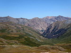
Hikers with time, energy and good weather will want to continue south along the CDT/CT. Past the junction the CDT climbs switchbacks on moderately-steep to steep grades to a high point at 3.5 miles. You are now standing atop the ridge separating Minnie Gulch and Maggie Gulch. To the east are great views of the summits rising above Pole Creek and its tributaries. To the north are more good views of Crown Mountain, Niagara Peak and Jones Mountain.
For even better views descend gently on the trail to an overlook above Maggie Gulch at 4.0 miles. This obvious stopping point is right before the CDT starts dropping on steeper grades toward the head of Maggie Gulch.
From the overlook, Sheep Mountain (13,292-ft.) dominates the view to the south while Canby Mountain towers above the divide to the southwest. In the distance to the east the high peaks of the Weminuche Wilderness, including the distinctive Rio Grande Pyramid and the Window, grace the skyline.
Extend the hike by continuing along the CDT as it follows an undulating path along the ridge rimming the east side of Maggie Gulch. Great views on this section of the trail now include Galena Mountain and the peaks rimming the west side of Maggie Gulch and the summits rising above the West Fork of Pole Creek (to the east).
When you are done explore the CDT to the south, turn around and retrace your steps to the trailhead.
Elevation Profile
| Buy the BookThis opinionated guide includes all the hikes in the Ouray, Telluride, Silverton and Lake City sections of the website plus info on local services and nearby attractions. |
Driving Directions
Driving directions from Silverton: Drive northeast through Silverton on Greene Street, the town’s main street, past the courthouse (on the left) and then bear right on County Road 2 toward Howardsville. The road is paved for the first 2.0-miles and then turns to a good gravel surface. Follow the road for 6.7 miles, passing the turnoffs for County Road 4 and Maggie Gulch (County Road 23) along the way. Turn right onto the Minnie Gulch Road (County Road 24).
Note: The road up Minnie Gulch requires 4WD/AWD vehicle with good clearance. Check on current road conditions at the Silverton Visitor Center before setting out.
The road climbs forested slopes on four switchbacks and then emerges onto a ledge road above Minnie Creek. The initial sections of the dirt road are typically well graded and include wide spots to facilitate passing other vehicles.
Soon the road temporarily narrows as it crosses over the creek. Past the crossing you will see the foundation for the Caledonia Mill on the left (north) side of the creek followed by wood structure (also on the left).
At 1.5 miles pass the intersection for the road climbing to the Kitty Mach and Caledonia Mines. Continue heading up the shelf road, passing a small cabin on the left. As you ascend the road becomes progressively rockier with some sections of the road completely covered by talus. There are still many spots for passing other vehicles.
At 1.3 miles past the Caledonia intersection (2.8 miles from the start of CR 24), you will see a pullout/parking area where the Minnie Gulch road curves to the left. Park here and find the brown stake marking the beginning of the trail. (The road continues beyond the trailhead for a short distance to the upper tailings for the Esmeralda Mine.)
Driving Directions From Ouray: Follow U.S. Highway 550 South from Ouray for 29 miles to the turnoff to Silverton and then follow the Silverton directions to the trailhead.
Trail Resources
Trail Intro / Trail Photo Gallery / Trail Map
Basecamp(s) Information:
Silverton
Region Information:
Southwest Colorado
Other Hiking Regions in:
Colorado