Details: Pass Creek and Engineer Mountain 
Distance: 4.8 - 12.8 miles (round trip)
San Juan National Forest, near Silverton in Southwest Colorado
Hike Facts
- Distance: 4.8 - 12.8 miles (round trip)
- Elevation: 10,670-ft. - 12,210-ft.
- Elevation Gain: 1,020-ft. - 2,425-ft.
- Difficulty: strenuous
- Trail Highlights: See Trail Intro
- Basecamp(s): Silverton
- Region: Southwest Colorado
This scenic hike, traveling through the high meadows to northwest of Coal Bank Pass, features terrific views of Engineer Mountain, Twin Sisters, the high peaks ringing the Cascade Valley and the summits rising to the south of Silverton.
Trailhead to Engineer Mountain Trail
Distance from Trailhead: 4.8 miles (round trip)
Ending/Highest Elevation: 11,690-ft.
Elevation Gain: 1,020-ft.
The Pass Creek Trailhead is located near Coal Bank Pass, south of Silverton, Colorado (see driving directions below). The trail, which starts from the northeast end of the trailhead parking area, ascends through meadows on moderate grades and soon enters viewless spruce-fir forest. After a half mile the path crosses a ridge and then turns west/northwest, climbing moderate switchbacks. The grade briefly abates after a mile as the path dips into a basin with a small pond.
Beyond the pond the ascent continues through trees and small intermittent meadows. Openings in the trees at 1.75 miles offer views of Grizzly Peak (13,738-ft.) rising to the northwest.
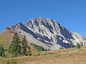
At 1.9 miles the grade briefly abates and trees thin. Ahead great views open to Engineer Mountain (12,968-ft.) towering above the meadows to the west. A short climb soon delivers you to the Engineer Plateau, a beautiful expanse of meadows below the iconic peak, at 2.25 miles.
From the plateau enjoy stunning views of Engineer Mountain. Jura Knob (12,614-ft.) and the summits of the Twin Sisters (13,432-ft., 13,374-ft.) rise to the north. Sultan Mountain (13,368-ft.), Grand Turk (13,148-ft.) and the summit of Bear Mountain (12,987-ft.), along with Kendall Peak (13,451-ft.) and a sea of 13,000-ft. peaks around Silverton fill the skyline to the west.
The trail now ascends west across the plateau on easy grades, reaching the junction at 2.4 miles with the Engineer Mountain trail. This is a good turn around point for hikers looking for a short day. The open meadows invite exploration and are a lovely place to hang out on a sunny day.
To the End of the Engineer Mountain Trail
Distance from Trailhead: 12.8 miles (round trip)
Ending/Highest Elevation: 12,210-ft.
Elevation Gain: 2,425-ft.
Hikers looking for a longer day should turn right (north) on the unmarked Engineer Mountain trail. Almost immediately the social trail used to climb Engineer Mountain branches to the left (west). (Note: This popular climb is difficult due to loose talus, a narrow ridge and exposure on the most difficult part of the climb.) We continue straight ahead (north) traversing pretty meadows on the Engineer Mountain trail.
The open meadows feature fine views of the peaks to the east/northeast. As you walk north Snowdon Peak (13,077-ft.) appears across the valley to the east. Soon North Twilight Peak (13,075-ft) and the Grenadier Range join the scene. Behind you the sheer north face of Engineer Mountain, eroded into deep fins, comes into view.
At 2.9 miles the trail passes through some scattered trees as it dips in and out of the bowl at the head of the Coal Creek drainage. A short distance beyond we reach a junction at 3.4 miles with the Coal Creek trail, which heads right (east). The sign at the junction indicates that the trail straight ahead (north) (the Engineer Mountain trail) leads to the White Creek and Colorado Trail while the Deer Creek Trail breaks from the Coal Creek trail to the east. We continue straight ahead (north) on the Engineer Mountain trail, which curiously is not listed on the sign.
Note: You may see references to a Pass Creek – Coal Creek Loop, which turns right (east) at this intersection and drops down to Highway 550, 3.0 miles north of the Pass Creek Trailhead. Completing the loop without a car shuttle requires a 3.0 mile walk along Highway 550. Highway 550 is a very narrow road with little or no shoulder and no guard rails. Walking along the road is not safe and not recommended.
Beyond the Coal Creek junction the trail ascends rolling meadows scattered with trees along the southern slopes of Jura Knob’s south ridge. To the west Sliderock Ridge (12,460-ft.) rims the north side of the Cascade Valley. Hermosa Peak (12,579-ft.) rises in the distance. Soon Grizzly Peak and San Miguel Peak (13,752-ft.), along the ridge to the north, come into view. To the southwest Grayrock Peak (12,504-ft.) anchors the south end of the ridge. On a clear day the La Plata Mountains, 15 miles northwest of Durango, are seen on the horizon.
Views of Engineer Mountain continue to change. The full north-face is soon in view. Massive talus fields, etched by meltwater, cover the lower slopes of the massif.
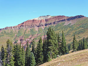
At 3.9 miles the ascent ends as the trail starts a traverse along the western slopes of Jura Knob’s south ridge. Ahead great views open to the multi-colored south face of Jura Knob and Peak 12,766-ft. at the head of the Engine Creek Valley. The Rolling Mountain massif (13,693-ft.) dominates the view in the distance.
At 4.7 miles the trail curves to the left (west) and descends a few steep switchbacks before crossing a gully along the south face of Jura Knob. Beyond the gully the trail descends through meadow with scattered trees on more moderate grades.
After losing about 240-ft. the path levels and reaches an unmarked junction at 5.2 miles with two trails. Here the Engine Creek trail makes a sharp left (south), descending toward the valley floor. The White Creek trail branches left (west/southwest) and traverses the slopes beneath the south face of Peak 12,703-ft. We continue straight ahead (north/northwest) on the Engineer Mountain trail that climbs steeply toward the head of the valley.
The grade abates briefly at 5.7 miles as we reach the upper basin ringed by Peak 12,703-ft. to the west, Peak 12,766-ft. to the north and Jura Knob to the east. The path now swings right (east) and then left (north) as it climbs through meadows and willow patches beneath Jura Knob’s western slopes.
At 6.0 miles the grade moderates as we reach a high, tundra-clad plateau. Ahead Twin Sisters dominates the view. The summit of Grizzly Peak appears above the ridge to the west.
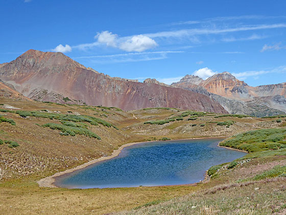
Stunning views open as we crest a low rise at 6.3 miles. Rolling Mountain, Beattie Peak (13,342-ft.), Fuller Peak (13,761-ft) and Vermillion Peak (13,894-ft.) grace the skyline to the north and form the backdrop for a small pond nestled in the meadows below the trail. Twin Sisters rise to the north/northeast while Jura Knob dominates the views to the southeast. Sultan and Grand Turk, along the peaks to the south of Silverton, rise to the east.
The Engineer Mountain trail ends at 6.4 miles at the junction with the Colorado Trail. To the right (northeast) the Colorado Trail descends along the West Lime Creek drainage and ultimately drops to Little Molas Lake and Highway 550 at Molas Pass. To the left (northwest) the Colorado Trail ascends to meet the Rico Silverton Trail and then climbs to Rolling Pass at 7.4 miles.
The junction with the Colorado Trail is the turnaround point for our hike. Find a nice spot with panoramic views overlooking the creek to take a break and have lunch before returning to the trailhead.
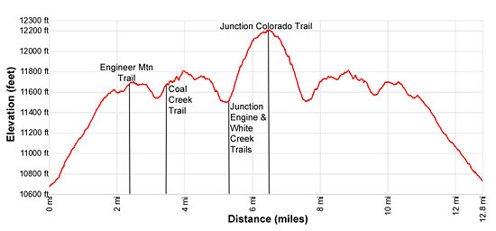
Elevation Profile
| Buy the BookThis opinionated guide includes all the hikes in the Ouray, Telluride, Silverton and Lake City sections of the website plus info on local services and nearby attractions. |
Driving Directions
From Silverton, Colorado: From the intersection of Highway 550 and the turnoff to Silverton (Green Street/CO Highway 110), drive 13.5 miles south on Highway 550 and turn right (west) on an unmarked dirt spur road. This is the trailhead for the Pass Creek Trail and Engineer Mountain. The turn is between mile posts 57 and 56, right before you reach Coal Bank Pass. Slow down when you see mile marker 57 so you don’t miss the turn. At the pass there is a parking lot with bathrooms on the left (east) side of the road. If you reach the pass, turn around and head back a short distance, looking for the dirt road on the left (west).
Trail Resources
Trail Intro / Trail Photo Gallery / Trail Map
Basecamp(s) Information:
Silverton
Region Information:
Southwest Colorado
Other Hiking Regions in:
Colorado