Bridal Veil Falls 
Distance: 4.0 miles
Uncompahgre National Forest, near Telluride in Southwest Colorado
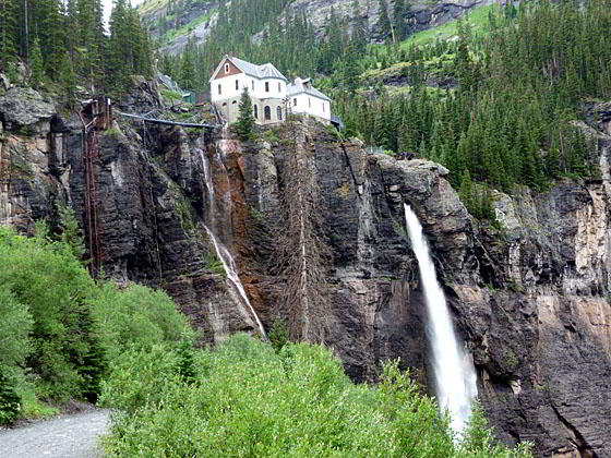
View of the falls and the historic power plant
This hike, ascending a jeep road, offers stunning views of Bridal Veil Falls, the tallest freefalling waterfall in Colorado, the historic power plant at the top of the falls and the Telluride valley. The views are an added bonus for hikers who walk or drive up the road to reach the Bridal Veil trailhead leading to Blue Lake, Lewis Lake and other destinations in the Bridal Veil basin.
- Distance: 4.0 miles (RT)
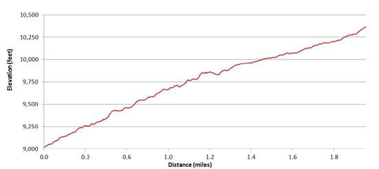
- Elevation: 9,020-ft. at Trailhead
Maximum elevation - 10,400-ft. - Elevation Gain: 1,380-ft.
- Difficulty: easy-moderate
- Basecamp: Telluride
- Region: Southwest Colorado
Trail Description - Bridal Veil Falls
The hike to the top of Bridal Veil Falls starts at a large parking area just past the Pandora Mill at the east end of Telluride (see the driving directions). From the parking area follow the dirt and gravel jeep road as it switchbacks up the northeast wall of the dramatic box canyon at the head of the Telluride valley. Colorful eroded canyon walls loom overhead while in the distance Bridal Veil Falls, Colorado’s tallest freefalling waterfall, plunges 365-ft. from just beneath the Bridal Veil power plant.
After negotiating a few switchbacks the road straightens out for about 0.5 miles, continuing its steady ascent to the canyon’s headwall. At the headwall the road climbs a series of long sweeping switchbacks to a dramatic viewpoint at the base of the falls at 1.2 miles. The viewpoint, located at a hairpin curve on one of the switchbacks, is often enveloped in mist from the water thundering over the rock face and hitting a small pool at the base of the falls.
The remaining 0.8 miles of the hike to the top of the falls enjoys wonderful vistas of Telluride Valley. Along the way great views open to the power plant perched on a ledge just above the falls. The building, restored in the 1990’s, is listed on the National Register of Historic places.
The power plant, the second oldest AC generation facility in the country, was built in 1907 to supply the Smuggler’s Union Mine. Water driving the generators is piped from Blue Lake (see Blue Lake trail description).
At the top of the fourth switchback from the base of the falls you will see a gate blocking vehicle access to the power plant. This is the beginning of the hiking trail up Bridal Veil basin. (The jeep road takes a sharp left before the gate, continuing its climb to Ingram Basin on the notorious Black Bear 4WD road.)
Duck through the large openings in the gate and follow the old mining road for a short distance to a overlook just above the power plant (on your right). Please stay on the road. The building and the area around the plant is private property.
While this is the turnaround point for many people, the pretty basin encourages further exploration. For more information on walks in the basin see the Blue Lake and Lewis Lake and Mine trail descriptions.
Note that two-way traffic is permitted on the jeep road between the Pandora Mine and the Power plant. The Black Bear Road above the power plant is one way – heading downhill toward Telluride. (The Black Bear Road starts south of Red Mountain Pass on Highway 550, goes over Black Bear Pass (12,840-ft.) and descends Ingram Basin on dangerous and difficult switchbacks to meet the jeep road coming up from Telluride.)
My advice is to get an early start if you plan to do this walk. Jeep traffic is much lighter in the morning due to the one-way restrictions on the Black Bear road. The road is also a favorite of mountain bikers. Keep a watch at all times for mountain bikes flying down the road.
Elevation Profile
Driving Directions
Drive east through Telluride on Colorado Avenue for a little over 2.0 miles past the Pandora Mill to a large unmarked parking area and park.
Trail Resources
- Trail Photo Gallery
- Trail Maps
- Basecamp(s) Information: Telluride
- Region Information: Southwest Colorado
- Other Hiking Regions in: Colorado