Details: Navajo Lake 
Distance: 9.2 miles (round trip)
Lizard Head Wilderness, San Juan National Forest, near Telluride in Southwest Colorado
Hike Facts
- Distance: 9.2 miles (round trip)
- Elevation: 9,320-ft. - 11,154-ft.
- Elevation Gain: 1,834-ft.
- Difficulty: moderate-strenuous
- Trail Highlights: See Trail Intro
- Basecamp(s): Telluride
- Region: Southwest Colorado
This popular hike climbs through forest and meadows to a stark alpine lake basin surrounded by high peaks in the Lizard Head Wilderness.
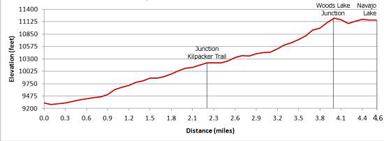
Trailhead to Kilpacker Trail Junction
Distance from Trailhead: 2.2 miles (one way)
Ending/Highest Elevation: 10,190-ft.
Elevation Gain: 870-ft.
There are two access routes to Navajo Lake from the south, the Navajo Lake Trail and the Kilpacker Trail, which meet and share the final 2.4 miles to the lake. The Navajo Lake trail is shorter and the lower portion of the trail is more scenic. The Kilpacker trail starts higher (10,060-ft.) and does not involve as much elevation gain. (See the Kilpacker Trail description in this guide for more information.)
From the Navajo Lake trailhead (see driving directions) follow the trail up the right (east) side of the West Dolores River past the Groundhog trail, which heads left (west) on a footbridge crossing the River. In less than a mile the Navajo Lake Trail crosses to the west side of the river on a bridge.
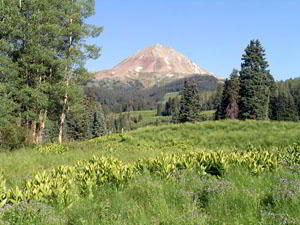
The trail now climbs above the river on moderate grades, traveling through wildflower-filled meadows and intermittent groves of mixed conifers. Views from the meadows include Dolores Peak (13,290-ft.) to the northwest and El Diente (14,159-ft.) to the east. After gaining 870-ft. in a little over 2.2 miles the trail meets the Kilpacker trail (coming in from the east) in a large meadow. The junction is marked with a small sign.
Junction to Navajo Lake
Distance from Trailhead: 9.2 miles (round trip)
Ending/Highest Elevation: 11,154-ft.
Elevation Gain: 1,834-ft.
Beyond the junction the trail ascends, steeply at times, through forest and meadows toward the head of the valley. The meadows offer nice views to the northeast of El Diente’s rust-colored western ridge and the ridge defining Navajo Basin’s northern wall.
At 3.1 miles the trail starts a steep climb up the valley's north wall. The trail breaks from the trees at 3.4 miles and ascends a series of steep switchbacks through meadows sprinkled with wildflowers and dispersed groups of trees to the junction with the Woods Lake trail at 4.0 miles, gaining 870-ft. over 0.9 miles. Turn right (east) at the signed junction toward Navajo Lake.
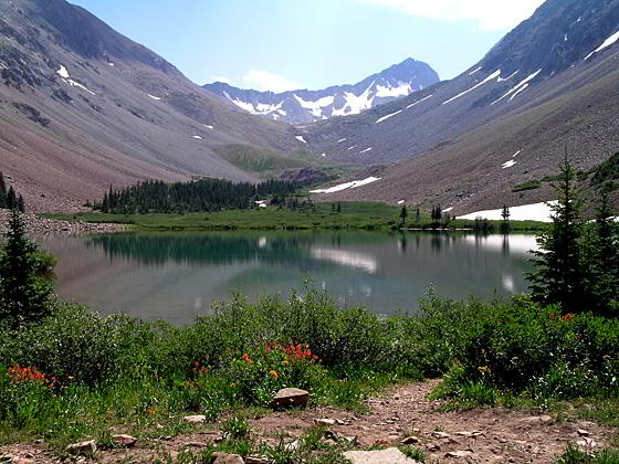
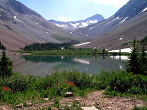
The trail climbs slightly, then drops 160-ft. and then climbs again to reach the western shore of Navajo Lake (11,154-ft) at 4.6 miles. The lake sits in a stark basin ringed by steep, rugged ridges. Gladstone Peak (13,913) rises above the headwall at the eastern end of the basin. El Diente (14,159-ft.) and Mount Wilson loom above the basin’s south rim, hidden from view by steep scree slopes. Wilson Peak (14,017) anchors the head of the basin’s northern wall but is also concealed from view.
This is the end of the day hike for most people. Backpackers camping at the lake and day hikers with excess energy (and good weather) can continue on the trail along the north side of the lake. Beyond the lake the trail climbs talus slopes to reach the upper end of the basin where it turns left (northwest) and climbs switchbacks up to the Rock of Ages saddle (13,000-ft.) and the junction with the new Rock of Ages trail, gaining 1,846-ft. in 2.4 miles. Total round trip from the Navajo Lake trailhead to the saddle is 14 miles.
Elevation Profile
| Buy the BookThis opinionated guide includes all the hikes in the Ouray, Telluride, Silverton and Lake City sections of the website plus info on local services and nearby attractions. |
Driving Directions
Driving directions from Telluride: Drive south from Telluride on Colorado 145 for 17.9 miles and turn right onto the Dunton Road (#207). The turnoff is located 5.4 miles south of Lizard Head Pass. The narrow gravel and dirt road ascends the hillside on a switchback and then traverses the northeast side of the Coal Creek drainage, crossing the creek in a little under 4 miles.
Continue on the Dunton Road and turn right (north) at the marked entrance for the Navajo Lake trailhead (7 miles from the intersection with Colorado 145). The turn off is located just beyond a sharp left curve in the road. Drive 0.1 miles to the parking area.
Trail Resources
Trail Intro / Trail Photo Gallery / Trail Map
Basecamp(s) Information:
Telluride
Region Information:
Southwest Colorado
Other Hiking Regions in:
Colorado