Details: Aiguilles Rouges Loop 
Distance: 5.4 - 11.0 miles (loop)
French Alps, near Chamonix in The French Alps
By: Diane Greer
Hike Facts
- Distance: 5.4 - 11.0 miles (loop)
- Elevation: 6,600-ft. - 6,562-ft.
- Elevation Gain: -38-ft.
- Difficulty: strenuous
- Trail Highlights: See Trail Intro
- Basecamp(s): Chamonix
- Region: The French Alps
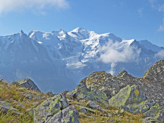
Enjoy amazing, nonstop views of Mount Blanc range on the strenuous loop hike climbing along the upper and middle slopes of the Aiguilles Rouges. The hike includes a stop at Lac Blanc, offering unparalleled views of the range.
Aiguilles Rouges Loop
This hike starts with a ride up the Planpraz-le Brevent gondola to the middle station at Planpraz (6,558-ft.) (see directions to the trailhead below). As you exit the lift you will see signs pointing northwest toward Col du Brevent, La Flegere and Lacs (Lakes) Noir and Lac Cornu.
Before starting the hike you’ll probably want to take a brief detour to the overlook in front of the lift station for views of Mont Blanc, Aiguille du Midi and the rest of the Chamonix Aiguilles (Chamonix Needles). The view is partially marred by ski lifts and cables.
Back at the signpost, ascend northwest on moderate to steeps grade along a broad track toward La Flegere. The trail winds around a low knoll and up through meadows, passing a restaurant and other ski facilities. Along the way you will probably see parasailers taking off from a grassy slope to the left (west) of the trail.
Reach a junction at 0.3 miles. Here the trail to Col du Brevent branches left. We turn right on the trail to La Flegere and Lacs Cornu and Lac Noirs.
At 0.5 miles the trail splits again. This is the starting point for our loop. The broader path branching right leads to Le Flegere and is used on the return leg of our loop. We bear left on the trail to Lac Cornu and Lacs Noirs
The trail now travels on easy grades through rocky meadows and a talus field. Across the valley enjoy fine views of Mont Blanc, Aiguille du Midi and the Chamonix Aiguilles (Needles). Ahead the Aiguille de Charlanon rises overhead.
After a mile the trail begins a steep climb through meadows and small rock slides up slopes beneath the east facing flanks of Aiguille de Charlanon. The grade abates briefly as the path dips around a rock outcropping at 1.5 miles. Soon the trail resumes its steep ascent, climbing talus slope and then switchbacks up rocky meadows. Along the way we pass the top station of a ski lift. Ignore the minor trail branching right near the lift.
The grade lessens and the switchbacks end at 1.8 miles. The path now become more rugged as it climbs to the Col Cornu (7,894-ft.) at 1.9 miles. A short distance beyond the pass impressive views open west to the cliffs along the Les Rochers des Fiz (the Fiz Rocks), part of the Plate massif. The cliffs form a stunning backdrop for Lac Cornu (7,467-ft.), nestled in a rugged bowl below the west side of the pass. The summit of Aiguille de Charlanon rises to the southwest. Panoramic views stretch across the Chamonix Valley to Mont Blanc, Aiguille du Midi and nearby peaks. A short distance beyond the pass is an unmarked junction with a rocky trail zig-zagging down to the lakeshore.
Past the junction our trail briefly climbs along the ridge and then ascends the slopes along the backside (west side) of Aiguille Pourrie (8,373-ft.). Here the rocky trail climbs through boulders and then scree slopes to the high point (8,130-ft.) of the hike at 2.25 miles. This section of the trail can be treacherous if covered with snow and ice. Check at the Chamonix Tourist Center for current conditions before setting out on the hike.
Past the high point the trail dips and then ascends slightly to reach the Col de la Gliere (8,074-ft.) and a signed junction at 2.4 miles. From the Col views stretch east/northeast to Aiguille Verte, Aiguille du Chardonnet, Aiguille &rsquodArgentiere and Aiguille du Tour towering above the east side of the Chamonix Valley.
At the junction a trail branches left, climbing to cross a ridge to a point just above the Lacs Noirs (0.6 miles round trip detour). The lakes, cradled in rock bowls, are a great destination if you are looking for a shorter hike. The trip to the Noir Lakes and back to Planpraz is 5.4 miles round trip.
To continue beyond the Col, take the trail toward L’Index. Initially we follow a route, marked by yellow paint splotches, that descends steeply down rock outcroppings. You will need to use your hands in a few places to facilitate the descent. Soon the route reverts to a trail dropping steeply down rocky meadows and scree slopes. Jagged crags tower overhead.
At 3.0 miles the grades abates a bit as the trail continues descending along the slopes beneath Aiguille la Gliere. Across the valley enjoy fine views of Aiguille Verte and the Grandes Jorasses soaring above the valley cradling the Mer Glacier. As you descend views expand to encompass Aiguille du Midi and Mont Blanc.
The descent ends at 3.25 miles. The path now ascends steeply, crosses an avalanche chute and then switchbacks up a talus slope to cross a ridge and reach the Col du Fouet at 3.6 miles. Here a sign points ahead (north) toward L’Index and Lac Blanc. Nearby a dirt road drops down to la Flegere, a lift station and site of the Chalet de la Flegere. The road offers an option to cut the hike short by dropping down to la Flegere where you can take a lift back to the Chamonix Valley or follow the Grand Balcon Sud back to Planpraz.
If time and energy permit, I recommend continuing along the trail toward L’Index and Lac Blanc. A broad path now climbs to L’Index (7,825-ft) at 3.9 miles. Unfortunately the area around L’Index is littered with ski pistes, lifts and buildings. Thankfully the fine views across the Chamonix Valley to the high peaks towering above the Le Tour and Mer glacial valleys will divert your attention from the eyesore. As will the summit of Aiguille de la Gliere rising above the trail.
Beyond L’Index, the trail descends through a small bowl and then climbs over a low ridge. Beyond the ridge the descent continues into a large bowl called the Combe des Aiguilles Crochues. The grade abates at 4.5 miles as the trail traverses a large, rocky avalanche chute beneath Aiguille Crochueres and then curves to the right (southeast), descending along the base of the peak’s southeast ridge.
At the end of the ridge the trail turns left (north/northeast) and enters the Aiguille Rouges Nature Reserve. A large rock cairn marks the boundary of the reserve. The path now climbs over the end of the ridge and then ascends the slopes beneath Aiguille du Belvedere, accompanied by the amazing panorama stretching from Mont Blanc to the peaks rising above the Le Tour Glacier.
At 5.3 miles reach a junction with the trail to Lac Blanc. The 0.6 mile round-trip detour to visit Lac Blanc (7,716-ft.) is highly recommended. Here two lakes are set amid rock outcroppings and features stunning, panoramic views of the Mont Blanc range. The popular Lac Blanc Refuges is located along the lower lake’s east shore. Aiguille du Belvedere and Aiguille de la Tete Plate tower above the lakes to the north.
When you are done enjoying Lac Blanc, retrace your steps to the junction and take the trail toward La Flegere. The trail descends steeply through meadows and rocky outcroppings with nonstop views of the Mont Blanc Range. Along the way the path passes a few junctions. At all intersections stay on the main path heading toward La Flegere.
At 7.0 miles reach the junction with the Tour du Mont Blanc (TMB) trail. To the left (northeast) the trail heads toward Col des Montets. We turn right on the TMB toward La Flegere. Here the grade abates as the broad path travels under ski lifts to the Chalet de la Flegere (6,158-ft.) at 7.3 miles. The refuge is near the cable car stations descending to Les Praz de Chamonix and the chair lift ascending to L’Index. From the refuge and area are Flegere enjoy impressive vistas of the high peaks soaring above the Mer Glacier.
If you wish to cut the hike short, take the cable car to Les Praz de Chamonix and then catch a bus back to Chamonix. Otherwise continue along the TMB in the direction of Planpraz. The undulating path now travels through meadows, clusters of trees and scree covered slopes, crossing ski service roads and passing a few trail junctions. At all junctions stay on the trail toward Planpraz. Magnificent views, stretching from Mont Blanc to the high peaks soaring above the Mer Glacier to the Aiguilles &rsquodArgentiere and du Chardonnet, accompany the hike.
At 9.3 miles the trail starts to climb on moderately steep grades toward Planpraz, reaching the end of the loop and the junction with the trail to Lac Cornu and Lacs Noirs at 10.5 miles. We turn left, continuing along the trail toward Planpraz.
Reach a second junction at 10.7 miles where the trail to Le Brevent and the TMB branches right. Here we turn left toward Planpraz, reaching the gondola station at 11.0 miles.
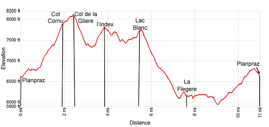
Elevation Profile
Driving Directions
From the Chamonix-Mont Blanc Train Station to Le Brevent-Planpraz Lift: Walk to the traffic circle in front of the train station. Walk half way around the circle and then head northwest on the Avenue Michel Croz for 0.2 miles and then turn left onto Rue Joseph Vallot. Walk one block and then turn right onto Place de l’Eglise. The Place de l’Eglise soon becomes the Place du Triangle de l’Amitie as it travels by the Chamonix Tourism Office.
Follow the Place du Triangle de l’Amitie to a traffic circle. Go half way around the circle, essentially straight, and then ascend the Rue la Mollard to the Planpraz-le Brevent lift station. This is a two stage lift with a gondola going to Planpraz (the middle station) and then a cable car ascending to le Brevent. Purchase a round trip ticket on the gondola to Planpraz.
For more information on bus schedules see the Chamonix Tourist Information site.
From the Flegere Cable Car station: follow the Chemin de ’Ecole to Route des Praz. Turn left left (northeast) on Route des Praz. In a short distance you will arrive at a bus stop. Take the #1 or #2 buses back to Chamonix. There is also a #2 bus that heads up the valley toward Le Tour.
For more information on bus schedules see the Chamonix Tourist Information site.
Trail Resources
Trail Intro / Trail Photo Gallery / Trail Map
Basecamp(s) Information:
Chamonix
Region Information:
The French Alps
Other Hiking Regions in:
France