Details: Grand Balcon Nord - Plan de l’Aiguille to Montenvers 
Distance: 4.5 - 5.7 miles (one way)
French Alps, near Chamonix in The French Alps
Hike Facts
- Distance: 4.5 - 5.7 miles (one way)
- Elevation: 7,578-ft. - 7,578-ft.
- Elevation Gain: 410-ft.
- Difficulty: moderate-strenuous
- Trail Highlights: See Trail Intro
- Basecamp(s): Chamonix
- Region: The French Alps
A high traverse along the Grand Balcon Nord features nonstop, panoramic views of Mont Blanc, the Chamonix Aiguilles, the Aiguille Rouges, Le Brevent and the Chamonix Valley. The hike ends at Montenvers with stunning view of the high peaks towering above the Mer Glacier.
Grand Balcon Nord - Plan de l’Aiguille to Montenvers
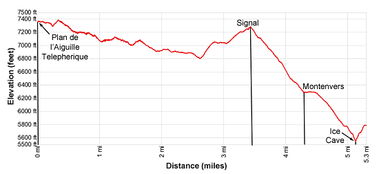
Elevation Information:
- Plan de l’Aiguille : 7,578-ft.
- Low point on the Grand Balcon Nord: 6,850-ft.
- High Point at Signal: 7,231-ft.
- Montenvers: 6,263-ft.
- Mer Glacier: 5,740-ft.
- Grand Balcon Nord lost/gain: +410-ft. / -1,657-ft.
- Side Trip to Mer Glacier: +/- 525-ft.
Walk or take the bus to the Aiguille du Midi Telepherique station in Chamonix and purchase a one-way ticket to middle station (Plan de l’Aiguille ). (See trailhead directions below.) From cable car station at the Plan de l’Aiguille , the trail descends short switchbacks and then turns north/northwest toward the Refuge du Plan de l’Aiguille and Montenvers Mer de Glace (the Mer Glacier at Montenvers). Signs near the restaurant at the cable car station will help get you started in the right direction.
From the area around the cable car station enjoy terrific views of the Aiguille du Midi and Mont Blanc towering overhead to the south/southwest. The Bossons Glacier spills down the north facing flanks of the Mont Blanc massif. Vistas stretch southwest down the Chamonix Valley to Les Houches and beyond.
At 0.5 miles reach the Refugedu Plan and a junction. The trail to the left is the Chamonix par les Grand Bois (trail to Chamonix via les Grand Bois). We turn right toward Montenvers Mer de Glace, Alpages de Blatiere and Pre du Rocher. From vantage points around the hut enjoy fabulous views of Le Brevent and the Aiguille Rouges soaring above the north side of Chamonix Valley (Val de l’Arve).
A short distance past the refuge is a second junction where the Pre du Rocher, the trail descending to Chamonix, branches left. We bear right on the trail toward the Montenvers Mer de Glace and Lapage de Blaitiere.
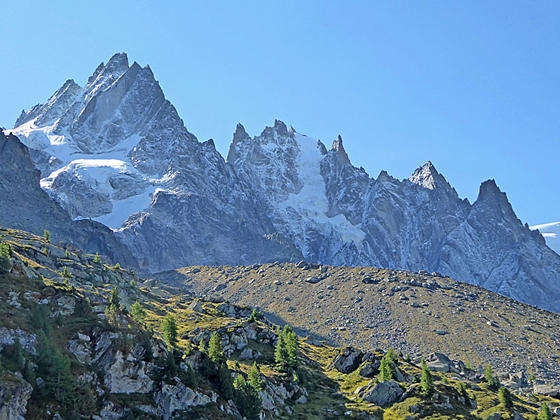
The trail briefly curves to the south as it drops down to cross a minor drainage. At 0.8 miles the trail swings to the left (east/northeast) and starts a descending traverse along the Grand Balcon Nord. The trail stays between 7,200-ft. and 6,800-ft. as it travels through rolling terrain below the terminal moraines of the Chamonix Aiguilles (Chamonix Needles). The jagged profiles of the Aiguille du Midi, Aiguilles du Plan, Aiguille de Blaitiere and Aiguille des Grands Charmoz loom above the trail. On a clear day you can easily see the complex atop the Aiguille du Midi,a popular tourist destination. Across the valley are more fine view of the Aiguille Rouges and le Brevent.
At 1.3 miles the trail crosses the moraine of the Blaitiere glacier and the streams draining the glacier. Beyond the moraine the path travels through meadows with more great views. Turn around to see the summit of the Aiguille du Midi.
At 1.8 miles pass a trail branching left to the Alpages de Blaitiere. Soon the path crosses the moraine of the Nantillion Glacier and the Torrent du Grepon, a meltwater stream emanating from the glacier, at 2.1 miles. The trail now traverses beneath the Aiguille Grepon, Aiguille des Grand Chamoz and the Aiguille de l’M.
At 2.4 miles a short spur trail branches left to a viewpoint above le Grand Chalet. Here we have stunning views stretching from Mont Blanc to the Grand Chamoz and across the valley to the Aiguille Rouges. This is a great place to take a short break.
Turn right at the junction at 2.6 miles toward Signal Forbes. The trail to the left, which is not recommended, is a shorter route to Montenvers that can be very difficult when covered with snow. Our trail climbs a series of short, steep switchbacks and then follows easier grades up the ridge toward the Signal Forbes overlook. Along the way enjoy ever improving views of the Aiguilles and Mont Blanc.
Near the crest of the ridge panoramic views open to Aigulle Verte (13,520-ft.), the green needle, considered by many to be the most beautiful peaks in the Mont Blanc massif due to its prominent ridges rising into the summit spire.
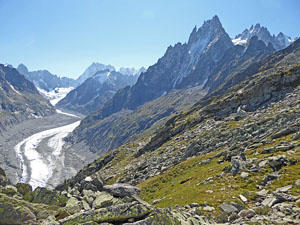
At 3.3 miles reach Signal (7,231-ft.) at the top of the ridge. Here a short spur trail leads to a fantastic overlook above the Mer Glacier, the largest glacier in France and the second largest glacier in the Alps. Panoramic views stretch up this massive river of ice flowing down a long valley surrounded by 12,000-ft. and 13,000-ft. peaks. Grandes Jorasses (13,805-ft.) towers above the head of the valley while les Drus, Aiguille Verte, Les Driotes and Aiguille de Talefre rim the valley to the east. Aiguille Charmoz rises to the west. The overlook is a great place for lunch. Find a seat atop a rock and spend some time marveling at the spectacle of rock and ice
When you finally pull yourself away from the overlook, follow the trail as it descends steep switchbacks to the Montenvers restaurant, hotel, museum and railway station at 4.3 miles. During the height of the summer the area is filled with tourist visiting the Grotte de Glace (ice caves) re-sculpted each year in the Mer Glacier.
A visit to the Ice Caves is well worth your time. There is a gondola that drops down the platform above the caves. I recommend walking down the trail to the caves. Signs along the way document the glacier’s retreat. The trail loses over 500-ft. as it descends to the edge of the moraine at 4.8 miles. Here a path heads out across the rock and ice to the entrance to the grottos at 5.0 miles. The tunnels drilled through the ice are backlit by lights for some magical results.
To return, either walk back up to the train station (5.7 miles) or return via the gondola (5.3 miles). At the station you can take the rack and pinon train back to Chamonix or walk back to town on the Chemin du Montenvers, a 3.2 mile trail that loses 2,765-ft.
Chemin du Montenvers (Trail from Montenvers to Chamonix)
From the Montenvers Train Station, walk north on the pavement and then turn left (west) on the pavement traveling along the south side of the hotel. Behind the hotel you will find the beginning of the trail, which initially heads north, staying to the left (west) of the train tracks. At 0.25 miles the trail curves to the left (west/southwest) and descends through a pretty larch forest. At 0.9 miles the path briefly drops down a series of tight switchbacks and then continues descending southwest, reaching the Buvette of Caillet, a snack shop at 1.4 miles. Openings along the way offer nice views of the Chamonix Valley.
Beyond the snack shop a few more switchbacks facilitate the descent toward the valley floor. At 2.25 miles the trail again drops down a series of tight switchbacks, crossing the train tracks along the way. Past the crossing the trail reaches a broad track that descends to the bottom station of the Montenvers Railway station at 3.2 miles after losing 2,765-ft. The station is located next to the Chamonix SNCF station.
Pre du Rocher to Plan de l’Aiguille (Trail from Chamonix to Plan Aiguille)
The Pre du Rocher trail starts along the east side of the du Grepon parking area, located on the south side of the N506 (the main highway in the l’Arve Valley). From the Aiguille du Midi Telepherique, head southeast on the Ave de Aiguille du Midi. Soon you will reach a pedestrian underpass the goes under the highway. Find the trail on the other side of the highway, between the east side of the parking area and the ski jump.
The trail wastes no time gaining altitude, climbing steep switchbacks through forest beneath the cable car route. Along the way the path crosses an old 4x4 track.
At Sur le Rocher the trail splits. Bear right on the trail to the Refuge du Plan de l’Aiguille. The path again climbs switchbacks, quickly gaining altitude. As you climb enjoy ever improving views of the Chamonix Valley. At 3.0 miles the trees give way to meadows and terrific views open to Mont Blanc, Aiguille du Midi and the Chamonix Aiguilles. As you near the refuge the grade abates. At 3.6 miles reach a junction, just below the refuge, with the Balcon du Nord trail heads east toward Montenvers. Total elevation gain for the trail is 3,800-ft.
Elevation Profile
Driving Directions
To the Aiguille du Midi Telepherique (Cable Car): From the train station in Chamonix (Gare de Chamonix-Mont Blanc), walk southwest on the Rue des Allogroges and then turn right onto Rue Helbonner. At the next traffic turn left on the Rue du Lyret. Follow Rue du Lyret to the Avenue de l’Aiguille du Midi. The lift station is on the southwest corner of the intersection. The walk should take about 8 minutes. For more information on train schedules and ticket prices see the Chamonix Website. The nearest bus stop to the cable car is Chamonix Sud.
Pre du Rocher trailhead at the Grepon Parking area: From the train station in Chamonix (Gare de Chamonix-Mont Blanc), walk southwest on the Rue des Allogroges and then turn right onto Rue Helbonner. At the next traffic turn left on the Rue du Lyret and then left on the Avenue de l’Aiguille du Midi. Continue on down du Midi and take the underpass (to avoid crossing the highway) to the du Grepon parking area and the Pre du Rocher trailhead. The walk should take about 10 minutes
For more information on train and bus schedules see the Chamonix Website.
Montenvers Mountain Railway (Chemin de Fer du Montenver): Walk to the northeast end of the train station in Chamonix (Gare de Chamonix-Mont Blanc) and turn right on a walkway that goes over the train tracks to the Montenver Railway station. The walk should take about three minutes. For more information on train schedules and ticket prices see the Montenvers and Mer Glacier website. The nearest bus stop to the Montenvers Railway is the Place du Mont Blanc.
For more information on train and bus schedules see the Chamonix Website.
Trail Resources
Trail Intro / Trail Photo Gallery / Trail Map
Basecamp(s) Information:
Chamonix
Region Information:
The French Alps
Other Hiking Regions in:
France