Details: Becker and Albino Lakes 
Distance: 5.0 - 12.2 miles (round trip)
Absaroka Beartooth Wilderness, Shoshone National Forest, near Cooke City in Beartooth Mountains
Hike Facts
- Distance: 5.0 - 12.2 miles (round trip)
- Elevation: 9,530-ft. - 10,000-ft.
- Elevation Gain: 130-ft. - 470-ft.
- Difficulty: easy-moderate
- Trail Highlights: See Trail Intro
- Basecamp(s): Cooke City / Red Lodge
- Region: Beartooth Mountains
The Beartooths is blessed with great day hikes but none can complete with the scenic beauty of the hike to Becker and Albino Lakes, where a succession of beautiful lakes and photogenic meadows serve up stunning views of the Beartooth Plateau’s high peaks and rugged landscapes.
Trailhead to the Meadows
Distance from Trailhead: 5.0 miles (round trip)
Ending/Highest Elevation: 9,660-ft.
Elevation Gain: 130-ft.
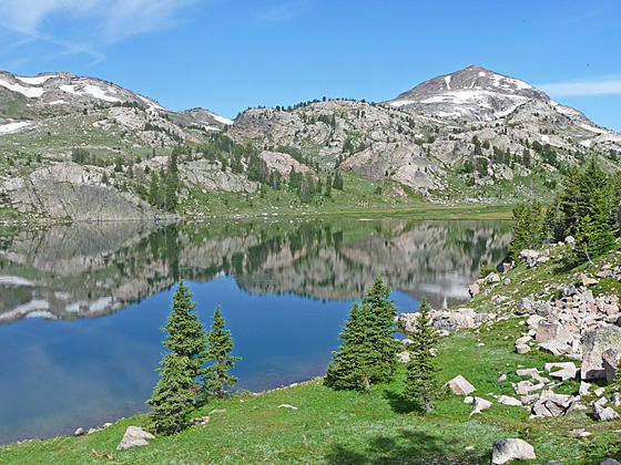
The Beartooth High Lakes trail (#620) to Becker and Albino Lakes starts near the foot of Island Lake (9,518-ft.) on the northeast side of the trailhead parking area (see driving directions below). The trail curves to the northwest and reaches the boat ramp at the foot of the lake at 0.25 miles. From here vistas extend north to Lonesome Mountain (11,409-ft.), Castle Rock Mountain (12,408-ft.), Castle Mountain (12,612-ft.), Sky Pilot Mountain (12,047-ft.) and the 11,000-ft. ridge rimming the eastern side of the Beartooth Plateau. Early in the morning the peaks are beautifully mirrored in the lake’s still waters.
Past the boat ramp the level trail curves around the foot of the lake, crosses the outlet stream at 0.4 miles and then heads northeast along the lake’s western shore. The walk is accompanied by more great views of the high peaks.
Reach the head of Island Lake at 1.1 miles. The trail now ascends gently along the stream connecting Island and Night Lakes, reaching the foot of Night Lake at 1.25 miles. Traverse the west side of Night Lake and then an unnamed tarn beyond the head of the lake.
Past the tarn the trail ascends 100-ft. on moderate-easy grades through scattered trees to the foot of a second tarn. We now travel along the east side of the tarn, cross a small stream at 2.5 miles and then pass to the east of a third tarn. Flake Lake lies nestle beneath the ridge to the east of the third tarn.
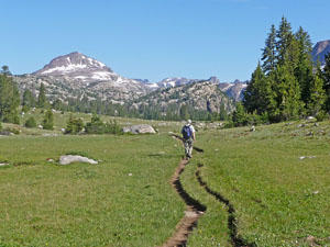
The scenery along this section of the trail is simply gorgeous. Lonesome Mountain and the distant peaks to the north form the backdrop for the expanse of emerald green meadows sprinkled with tiny flowers. To the east a massive ridge rims the east side of the lakes basin.
To Mutt, Jeff and Becker Lake
Distance from Trailhead: 8.0 miles (round trip)
Ending/Highest Elevation: 9,770-ft.
Elevation Gain: 240-ft.
The views continue to expand and evolve as we wander on easy grades through the meadows to the east of Flake Lake. At 2.9 miles the trail curves to the left as it passes through some trees and then gently descends. Keep an eye out for cairns and a use/social trail branching right (north) at 3.0 miles. The High Lakes trail curves to the left (northwest) and starts heading downhill. (You missed the turn onto the use/social trail if you start heading downhill and encounter a switchback. Continuing on the wrong trail will soon lead to a junction above Beauty Lake.)
Head right on the use trail, which passes between two tiny tarns and then heads through scattered trees. Soon views open to a small lake to the right (east). A short distance beyond the trail climbs over a low knoll. As you descend from the knoll views open to two lakes, Mutt and Jeff. Jeff is the larger lake to the right (east).
At 3.4 miles the trail crosses a broad, marshy area connecting the two lakes. Rocks and small grassy islands keep your feet dry. Past the crossing the trail curves around the left (west) side of Jeff Lake and soon reaches a small boulder field. Work your way through the boulder field to the head of the lake at 3.6 miles. Early in the season this area can be quite marshy.
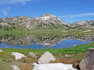
The trail now climbs a hill clad in meadows, boulders and trees on moderately-steep grades, gaining 70-ft. in 0.2 miles. A small tarn lies amid huge boulders on the broad hilltop. Past the tarn the trail descends through pretty meadows and rock outcroppings to the eastern shore of Becker Lake (9,693-ft.) at 4.0 miles. Here views open to Lonesome Mountain rising beyond the rocky knolls to the northwest. Across the lake the western shore is rimmed by sheer granite cliffs.
This is a good turn around point for parties looking for a shorter day. A use trail breaks off toward the shore, following the contours of the shore line to rock outcroppings jutting into the lake. This is a beautiful area for relaxing, fishing and/or enjoying a picnic lunch.
Back at the main trail, an undulating path heads northwest and then north through meadows and over low knolls along the east side of the lake, crossing a small creek along the way. A steep knoll midway along the eastern shore prevents easy access to this part of the shore.
As you approach the head of the lake enjoy fine views of Lonesome Mountain and the granite ridge rising above the west side of the lake. At 4.9 miles reach the head of the lake, a marshy area where several stream flow into Becker Lake.
Becker to Albino Lake
Distance from Trailhead: 12.2 miles (round trip)
Ending/Highest Elevation: 10,000-ft.
Elevation Gain: 470-ft.
Many parties stop either at the first views of Becker Lake or continue to the head of the lake before returning to the trailhead. If time and energy allow, I recommend continuing another mile to Albino Lake.
At the head of Becker Lake the trail climbs on moderate and then moderately-steep grade along the east side of the stream flowing between Albino and Becker Lakes. Early in the season areas along the trail can be marshy and you may find lingering snowfields.
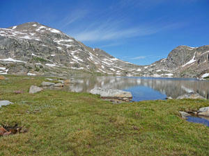
At 5.6 miles the grade abates as the trail continue along the east side of Albino Lake’s outlet stream. Ahead stunning views open to the Lonesome Mountain. Reach the southeast end of Albino Lake at 5.9 miles. Lonesome Mountain towers above the west side the lake while steep cliffs, whose lower slopes are covered by large talus fields, rise above the lake to the east. Cross the outlet stream and walk left (west) along the foot (south end) of the lake for more great views of the rugged peaks and ridges rimming the lake basin. The south shore offers many great spots for taking in the views. Angler may want to try their luck at catching the lake’s cut throat trout.
When your done enjoy the lake, retrace your steps to the trailhead for a 12.2 mile hike.
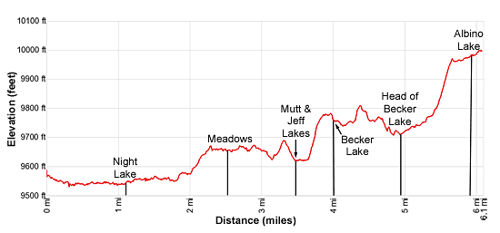
Elevation Profile
Driving Directions
From Cooke City. MT: Drive east on US 212 E (the Beartooth Highway) for 29.5 miles and turn left at the turnoff for Island Lake (Forest Road 418). Follow the road for 0.3 miles and turn right on the marked spur road leading to the trailhead parking area. The trail leaves from the northeast end of the parking area. Do not park by the lake at the area reserved for boat launching or in the campground.
From Red Lodge, MT: Drive southwest on US 212 W (the Beartooth Highway) for 39.7 miles and turn right at the turnoff for Island Lake (Forest Road 418). Follow the road for 0.3 miles and turn right on the marked spur road leading to the trailhead parking area. The trail leaves from the northeast end of the parking area. Do not park by the lake at the area reserved for boat launching or in the campground.
Trail Resources
Trail Intro / Trail Photo Gallery / Trail Map
Basecamp(s) Information:
Cooke City / Red Lodge
Region Information:
Beartooth Mountains
Other Hiking Regions in:
Montana