Details: The Garden Wall / Highline Trail 
Distance: 4.0 - 11.6 miles (round trip)
Glacier National Park, near St Mary in Glacier Natl Park, MT
Hike Facts
- Distance: 4.0 - 11.6 miles (round trip)
- Elevation: 6,646-ft. - 7,330-ft.
- Elevation Gain: 684-ft.
- Difficulty: moderate
- Trail Highlights: See Trail Intro
- Basecamp(s): St Mary / West Glacier
- Region: Glacier Natl Park, MT
One of my favorite trails in the park, this moderately easy hike along the western flanks of the Continental Divide features panoramic views of the Livingston and Lewis Ranges along with excellent wildlife viewing opportunities.
Garden Wall Loop
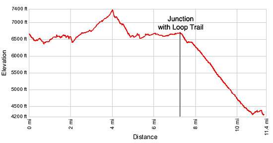
Elevation Gain to Granite Park Junction with the Highline Trail: +684-ft. Elevation Loss from the Granite Park Junction to the Loop: -3,070-ft.
Note: This is a terrific trail with wonderful views. It is great for a short hike -- simply walking out as far as time and energy permit – or for a long loop hike, as described below. No matter how far you go you will not be sorry you took the time to hike the trail.
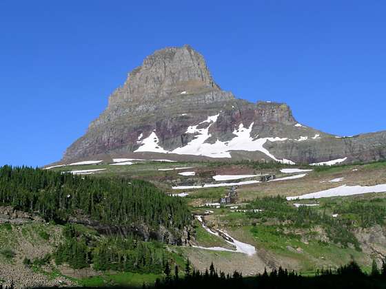
The Garden Wall/ Highline trailhead is located on the north side of the Going-to-the-Sun Road, across from the entrance to the Logan Pass Visitor Center (6,646-ft.). From the trailhead enjoy fine views of Reynolds Mountain (9,125-ft.) to the south, Clements Mountain (8,760-ft.) and Oberlin Mountain (8,180-ft.) rise the west and Pollack (9,190-ft.) to the northeast.
The trail descends on gentle grades through meadows sprinkled with stands of subalpine Engelmann Spruce and firs and then winds around cliff on a rock ledge at 0.3 miles. Fixed cables along the cliff wall provide a degree of security during slippery and windy conditions. Below the trail the Going-to-the-Sun Road is seen climbing a steep switchback to Logan Pass.
At 0.7 miles the descent ends. The trial now traverses on easy grades along the western slopes of Pollack Mountain and the Bishops Cap (9,127-ft.). The jagged ridge and peaks along this section of the trail are known as the Garden Wall. Here snow melt from the sheer ridge support a profusion of wildflowers growing in the alpine tundra. Mountain goats and Big Horn Sheep are often seen climbing on the cliffs above the trail and grazing in the alpine meadows around the trail. An occasional bear may also be spotted slopes near the trail.
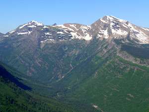
Soon views open to Heavens Peak, McPartland Mountain and the Glacier Wall towering above the McDonald Creek Valley to the west. Be sure to turn around to enjoy nice views of Bird Woman Falls tumbling down a steep cliff between Mt. Oberlin and Mt. Cannon (8,952-ft.) to the south.
At 3.0 miles the trail curves to the west beneath Mount Gould and climbs switchbacks to Haystack Pass, the saddle to the east of Haystack Butte (7,486-ft.). Panoramic views from the top of the saddle encompass the peaks rising above the Logan Pass area, the sheer cliffs and peaks along the Garden Wall and the Livingston Range to the northwest.
Beyond the saddle the trail continues ascending on moderate grades through alpine meadows and scree covered slopes to the high point on the trail (~7,300-ft.) at 4.1 miles. This is a very scenic section of the trail with terrific views of the surrounding peaks.
From the high point the trail descends on moderately steep grades through pretty meadows. Soon scattered stands of subalpine firs begin to appear. At 5.1 miles the grade abates as the trail traverses the western slopes of the Garden Wall on easy grades. Fine views open to Swiftcurrent Mountain, rising to the north.
Reach the junction with the Grinnell Glacier Overlook trail at 6.7 miles. The steep trail, branching to the right (east), climbs almost 1,000-ft in 0.8 miles to a view point on the ridge looking down upon the Salamander and Grinnell Glaciers, Upper Grinnell Lake and Mount Gould.
Past the junction with the overlook the trail traverses through meadows sprinkled with stunts firs on easy grades. The Granite Park Chalet is now visible on a low ridge to the northwest.
At 7.6 miles arrive at junction. Here you will find the continuation of the Highline heading north, the Granite Park (aka the Loop) trail and the spur trail to the Granite Park Chalet. If time permits its worth visiting the Chalet, a National Historic Landmark. The stone and log structure, built by the Great Northern Railway Company in 1913 and 1914, offers rustic overnight accommodations in 12 rooms with two-six bunks each. Meals can be ordered ahead of time or parties can prepare their own meals in a basic shared kitchen.
After you are done exploring the area around the Chalet, return to the junction and turn left (southeast) on the Granite Park (Loop) trail. Follow the trail as it descends on moderately-steep grades through meadows and stands of stunted firs. At 7.8 miles the grade abates and soon passes a trail to the right (north) toward the Granite Park backcountry campground. A short distance past the junction the trail resumes its moderately-steep descent through a forest of spruce, firs and pines with intermittent views of the Garden Wall and surrounding peaks.
At 8.6 miles the trees give way to open slopes. Heavens Peak towers above the McDonald Valley to the southwest. Soon the trail hits the area burnt by the Trapper Creek Fire of 2003, which scorched 19,000 acres. For the remainder of the descent the trail passes through a ghost forest of burnt trees. Thankfully the regeneration of the burn area is well underway. A profusion of wildflowers and low vegetation now covers the slopes beneath the remnants of dead trees.
Reach the junction with the Packer’s Roost trail, branching to the right, at 10.9 miles. Beyond the junction the trail climbs briefly and then descends to a bridge crossing a creek draining Granite Park. The trail ends at the Loop, a hairpin curve on the Going-to-the-Sun Road, at 11.6 miles. Here you can catch a shuttle bus heading east toward Logan Pass or the bus heading west to the Apgar Visitor Center at the foot of Lake McDonald on the west side of the park.
Elevation Profile
Driving Directions
From St. Mary, MT: Head west on the Going to the Sun from for 18 miles to Logan Pass. The pass is an extremely popular area with limited parking. Consider riding the shuttle bus to avoid wasting time waiting for a parking spot to open.
From West Glacier, MT: – Head north/northeast on the Going to the Sun Road for 32 miles to Logan Pass. The pass is an extremely popular area with limited parking. Consider riding the shuttle bus to avoid wasting time waiting for a parking spot to open.
Glacier National Park Shuttle Bus: The Glacier National Park Shuttle bus, which operates from the beginning of July through the first week of September (check current schedule on the park’s website: http://www.nps.gov/glac/planyourvisit/shuttles.htm), runs in two sections. On the west side of the Park shuttle buses run from Apgar Visitor Center to Logan Pass. The east side of the Park the shuttle runs from the St. Mary Visitor Center to Logan Pass.
Trail Resources
Trail Intro / Trail Photo Gallery / Trail Map
Basecamp(s) Information:
St Mary / West Glacier
Region Information:
Glacier Natl Park, MT
Other Hiking Regions in:
Montana