Details: Gunsight Pass 
Distance: 19.4 miles (one way)
Glacier National Park, near St Mary in Glacier Natl Park, MT
By: Diane Greer
Hike Facts
- Distance: 19.4 miles (one way)
- Elevation: 3,220-ft. - 7,050-ft.
- Elevation Gain: 2,131-ft. - 3,830-ft.
- Difficulty: strenuous
- Trail Highlights: See Trail Intro
- Basecamp(s): St Mary / West Glacier
- Region: Glacier Natl Park, MT
Memorable backpack over Gunsight and Lincoln Passes travels by gorgeous Gunsight Lake and Lake Ellen Wilson set amid towering peaks adorn with glaciers and waterfalls. Wildflowers and wildlife add to the hike’s delights.
Jackson Glacier Overlook to Gunsight Lake
Distance from Trailhead: 6.0 miles (one way)
Ending/Highest Elevation: 5,351-ft.
Elevation Gain: 706-ft.
The point-to-point hikes starts at the Jackson Glacier Overlook along the Going-to-the-Sun Road (see driving directions below). Before starting the hike take time at the overlook to view the Jackson Glacier clinging to Mount Jackson’s north face. The glacier is the 7th largest of the 25 remaining glaciers in the park.
From the overlook take the Piegan Pass (signed for the Gunsight Pass trail) toward the Gunsight Trail junction. The path descends southeast through a spruce-fir forest on moderate to moderately steep grades. At 1.1 miles views open to lovely Reynolds Creek to the right (west) of the trail.
At 1.2 miles take a short detour to the rock ledge above the creek to see Deadwood Falls. The falls tumbles down several levels of interested red mudstone formations. Pretty pools separate the drops.
Past the falls the trail turns left (east) and reaches the signed Gunsight Trail Junction at 1.25 miles. Straight ahead leads to Sun Point. We turn right (south) on the Gunsight Pass trail toward Gunsight Lake. The trail drops down and cross Reynolds Creek on a swing brings. On the far side of the bridge a spur trail leading to the Reynolds Campground.
Beyond the crossing the trail gradually swings to the right (southwest), traveling through forest on easy grades to the north of the St. Mary River. For most of the way the forest obscure the views, although occasional openings offer views of Dusty Star (8,064-ft.) and Citadel Mountain (9,030-ft.) rising to the south. The first good opening is reached at 1.8 miles as the trail briefly travels along the north shore of the St. Mary River.
At 2.7 miles the trail passes to the north of pretty little Mirror Pond set amid a lovely marshy meadow. Here terrific views open southwest to Mount Jackson, Fusillade Mountain (8,750-ft.), Gunsight Mountain (9,258-ft.) and Gunsight Pass.
Reach the junction with Florence Falls at 3.7 mile. Keep left to stay on the Gunsight Pass trail. The Florence Falls trail, branching right, leads to the base of a gorgeous falls that spills down a series of rock ledges. The round-trip detour to the falls is 1.4 miles.
Beyond the falls the trail ascends on easy to moderately-easy grades. At 4.3 miles the trail starts an ascending traverse along the lower slopes of Fusillade Mountain. A half mile beyond the forest gives way to meadows with scattered clusters of trees. To south enjoy great views of Citadel Mountain, Mount Logan (9,239-ft.), Blackfoot Glacier, Jackson Glacier and Mount Jackson (10,052-ft.).
The grade abates at 5.5 miles. Here views open to Gunsight Pass, the saddle on the ridge between Gunsight Mountain and Mount Jackson. As you proceed through meadows enjoy ever improving views of the high peaks towering above the head of the valley.
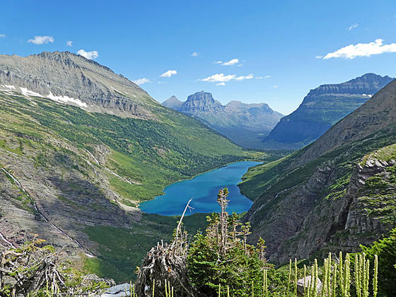
At 5.9 miles pass a trail branching left to a patrol cabin. We continue straight ahead to the foot of breathtaking Gunsight Lake (5,351-ft.) at 6.0 miles. Just before the foot of the lake a spur trail branches left, leading to the Gunsight Lake Campground.
Views extend the length of the lake to the sheer headwall below Gunsight Pass. Mount Jackson soars above the south side of the lake while the Gunsight Mountain massif dominates the views to the west/southwest. Fusillade Mountain towers above the lake to the north. Glaciers and snowfields clinging to the high slopes of Gunsight Mountain feed a series of beautiful waterfalls tumbling down the peak’s rugged slopes and into the lake.
Gunsight Lake to Sperry Chalet Area
Distance from Trailhead: 13.2 miles (one way)
Ending/Highest Elevation: 7,050-ft.
Elevation Gain: 3,190-ft.
At the foot of Gunsight Lake the trail turns south, traverses the foot of the lake and then crosses a swing bridge over the St. Mary River at the lake’s outlet. Beyond the bridge the Jackson Glacier trail branches left. Bear right on the Gunsight Pass trail that climbs long, moderately-steep switchbacks through meadows and low shrubs along the northwest facing flanks of Mount Jackson. As you ascend enjoy ever improving views of Gunsight and Fusillade Mountains and the lake.
At 7.3 miles the trail ascends along a section blasted from a cliff. Early in the season a gushing falls tumbling down the cliffs will get you wet.
Past the cliffs the path ascends steep switchback up rocky meadows and then starts curving to the southwest toward the pass. Snow fields linger long into the season along the steep slopes. Be sure to turn around here for wonderful views
Across the valley waterfalls stream down the Gunsight Mountain’s colorful slopes. To the northeast, Going-to-the-Sun Mountain (9,642-ft.), Matahpi Peak (9,365-ft.) and Goat Mountain (8,826-ft.) fill the skyline. Citadel Mountain rises along the east side of the St. Mary Valley.
At 8.3 miles the trail dips into a gully channeling meltwater from the slopes above. A short distance beyond a second beautiful waterfall spills over the trail. Soon the trail curves round a minor ridge and climb steeply to Gunsight Pass (6,946-ft.) at 8.9 miles.
From the pass enjoy terrific views of the waterfalls and glaciers along Mount Jackson’s northwest-facing slopes. To the southwest views stretch down the length of Lake Ellen Wilson and beyond. The Gunsight Mountain massif dominates the view to the northwest. Atop the pass is a small rock shelter. Mountain goats are likely to be wandering around the pass.
After taking in the views descend from the pass toward Lake Ellen Wilson on steep to moderately steep grades. The descent is accompanied by fine views of the Gunsight Mountain massif, Mount Jackson and Lake Ellen Wilson. As you descend the trail crosses a few streams and enjoys great views of the waterfalls, fed by snow and glacial melt-water, spilling down Mount Jackson’s rugged slopes.
After losing 925-ft. in 1.1 miles the trail reaches a beautiful waterfall on the inlet stream at the head of Lake Ellen Wilson gushes across a broad swath of the trail at 10.1 miles. Except for late in the season, expect to get your feet wet.
Beyond the falls the trail heads northwest, ascending around the head of the lake and then curves to the left west/southwest, climbing along the south facing flanks of Gunsight Mountain. As you proceed the trail climbs higher above the northwest shore of Lake Ellen Wilson. At 10.6 miles pass the junction with the trail descending to the Lake Ellen Wilson Camping area. This 0.3 miles spur trail loses about 250-ft. as it descends to the lakeshore.
The trail now begins a moderate ascent across the avalanche slopes beneath Peak 9,258-ft. Soon the trail crosses a creek. Above the trail a beautiful waterfall cascades down the rugged slopes beneath the peak. In season a profusion of wildflowers blanket the well-watered slopes along this section of the trail.
At 10.9 miles the ascent steepens as the path climbs on moderately-steep grades through meadows and talus slopes scattered with trees. Mount Jackson and Lake Ellen Wilson dominate the view to the east. Above the trail rugged Peak 9,258-ft. competes for you attention.
The trail curves to the right (northwest) around the ends of a rugged ridge at 11.5 miles and then climbs to a bench beneath the south-facing slopes of Peak 7,870-ft. Here an undulating path heads west, traversing along the bench clad in meadows and rock outcroppings. Below the bench steep slopes drop over 2,300-ft. to the shores of Lincoln Lake. To the southwest are distance views of the Great Bear Wilderness.
At 12.1 miles the trail exits the bench as it rounds a ridge. Here views open to Lincoln Pass. A short, steep climb, aided by a few switchbacks, leads to Lincoln Pass (7,050-ft.) at 12.6 miles. From the pass enjoy fine views of Mount Jackson (10,052-ft.) towering over the Lake Ellen Wilson Basin. To the west is Lake McDonald. Lincoln Peak rises along the ridge to the south. Below the results of the 2017 Sprague Creek Fire are on display. The fire left a patchwork of trees with some areas burnt and others untouched.
Drop from the pass on steep switchbacks through meadows and talus slopes. The grade moderates a bit as it passes a small tarn and reaches the junction with the Sperry Campground amid meadows with scattered trees at 12.9 miles. A moderately steep descent leads to the Sperry Chalet area at 13.2 miles. The area around the chalet and dining enjoy fine views of the massive cirque surrounding Glacier Basin to the north. The cirque, anchored by Edwards Mountain (9,072-ft.) to the west and Peak 9,258 to the east, is truly stunning. Waterfalls spill down the cirque’s steep cliffs, watering the basin’s emerald green meadows.
The Chalet’s dormitory was burnt during the 2017 fire. Rebuilding is underway. If all goes well the Chalet will reopen to overnight accommodations in 2020. In the meantime, the dining room and campground remains open during the rebuilding period. Check the Glacier National Park [http://www.nps.gov/glac/] and Sperry Chalet websites [http://www.sperrychalet.com/] for the most up-to-date information.
If you are lucky enough to get an advanced reservation at the campground or the Chalet when it reopens, I highly recommend adding a trip to the Sperry Glacier to your itinerary. See the Sperry Glacier trail description for more information.
Sperry Chalet Area to the Gunsight Pass Trailhead near Lake McDonald Lodge
Distance from Trailhead: 19.4 miles (one way)
Ending/Highest Elevation: 6,550-ft.
Elevation Gain: -3,360-ft.
The mileage in this description assumes you are starting from the Sperry Chalet. If starting from the Sperry Campground subtract 0.3 miles from distances in the description.
From the Chalet, the Gunsight Pass trail descends through trees on switchbacks to the Sperry Glacier Trail at 13.6 miles. Openings in the trees provide glimpses of waterfalls tumbling down the steep slopes of Glacier Basin.
Past the junction the trail curves around the foot of Glacier Basin, crossing a bridge over Sprague Creek at 13.7 miles. From the meadows around the bridge enjoy great views of Glacier Basin.
Beyond the crossing ignore an unmarked trail branching right. The trail now curves to the southwest and exits the trees, descending on moderately steep grades down the west side of Sprague Creek. Look up to see the Sperry Chalet perched on a high cliff to the left (east).
Soon the trail starts dropping down switchback through scattered trees. At 15 miles look left to see Medicine Bear Falls. As you descend the trees thicken, obscuring the views.
The grade abates at 16.4 miles. Soon the trail curves to the right around the end of Mount Edward’s southwest ridge, descending through forest on moderate grades above the north side of Sprague Creek.
At 17.3 miles the trail crosses a low ridge into the Snyder Creek Valley and drops down to cross Snyder Creek on a bridge at 17.7 miles. Just before the crossing the Snyder Creek trail branches to the left (south). Beyond the crossing pass the junctions of the Snyder Creek and Mount Brown trails branching right at 17.8 and 17.9 miles respectively.
Past the junctions the trail descends on moderately-steep grades. Along the way are a few short, steep drops. Openings in the trees offer views of the How Ridge rising above the west side of Lake McDonald.
At 18.4 miles we leave the burnt trees behind and continue the descent through a forest of old mature western hemlocks, red cedars and larches. Just before reaching the trailhead the Avalanche Trail branches left and we pass to the south of a horse stable.
Reach the end of the Gunsight Pass trail at 19.4 miles. The trail is located across from the Lake McDonald Lodge. The shuttle bus stop is located across from the Camp Store to the northwest of the lodge.
Snow lingers long into the season around Gunsight Pass. Check on current trail conditions before setting on this backpack. The trail between the Jackson Glacier Overlook and Gunsight Lake travels through sections of waist to shoulder high vegetation. Be sure to make noise when going through dense vegetation so that you don’t inadvertently surprise a bear.
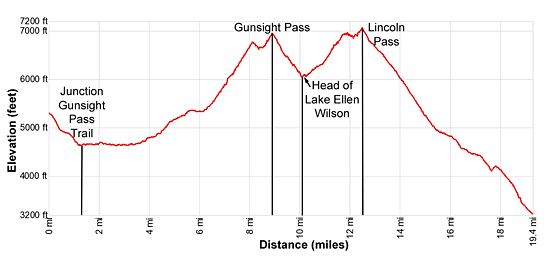
Elevation Profile
Driving Directions
Jackson Glacier Overlook Trailhead
From St. Mary, MT: From the intersection of Highway 89 and the Going-to-the-Sun Road, drive 12.6 miles west on the Going-to-the-Sun Road to the Jackson Glacier Overlook parking area on the south side of the road. Parking is limited. Unless you get an early start, consider taking the shuttle bus to avoid parking problems.
From West Glacier, MT: From the junction of US-2 and the Going-to-the-Sun Road, turn northwest on the Going-to-the-Sun Road and follow the road for 2.0 miles to a junction with the Apgar Visitor Center. Turn right to continue on the Going-to-the-Sun Road. Follow the road for 35.4 miles to the Jackson Glacier Overlook parking area on the south side of the road. Parking is limited. Unless you get an early start, consider taking the shuttle bus to avoid parking problems Gunsight Pass Trailhead on the west side of the park near the Lake McDonald Lodge
From West Glacier, MT: From the junction of US-2 and the Going-to-the-Sun Road, turn northwest on the Going-to-the-Sun Road and follow the road for 2.0 miles. Turn right at the junction with the Apgar Visitor Center to stay on the Going-to-the-Sun Road and continue along the road for 8.9 miles. A crosswalk across the road signals the beginning of the Gunsight Pass/Sperry Chalet Trail on the right (east).
Take the next left on an unmarked one-way road with a small wood building at the corner. Along this road you will find parking for the Lake McDonald Lodge and the trailhead. At the first intersection turn left on the road that runs parallel to the front of the Lodge. A short distance beyond take your next left on a one-way road heading back to the Going-to-the-Sun road. This road also includes parking for the Lake McDonald Lodge and the trailhead. Find a parking spot along the road and then walk the rest of the distance up the road to the Going-to-the-Sun Road. Carefully cross the Going-to-the-Sun Road using the crosswalk. The trailhead for the Gunsight Pass trail is on the east side of the road.
The parking lots around the Lake McDonald Lodge can be very congested. Typically in the morning, when people are checking out, you should be able to find a space. Alternative take the shuttle bus from the Apgar Visitor Center, a better option during the height of the summer when parking is limited.
Shuttle Bus
From St. Mary, MT: From the intersection of Highway 89 and the Going-to-the-Sun Road, drive 0.5 miles to the St. Mary Visitor Center and park. Take the Glacier Shuttle Bus, starting at the St. Mary Visitor center, to the Jackson Glacier Overlook stop. The return journey boards the Shuttle Bus across from the Camp Store near the Lake McDonald Lake stop and requires a bus change at Logan Pass to return to the St. Mary Visitor Center. Shuttle buses run approximately every 15 minutes. Check at the Visitor Center for the most up-to-date information.From West Glacier, MT: From the junction of US-2 and the Going-to-the-Sun Road, turn northwest on the Going-to-the-Sun Road and follow the road for 2.0 miles to a junction with the Apgar Visitor Center. Cross the intersection, continuing into the parking lot for the Apgar Visitor Center. Park and take the shuttle bus to Logan Pass. At Logan Pass change for a shuttle bus heading to St. Mary and get off at the Jackson Glacier Overlook stop. For the return, catch the Shuttle Bus to the Apgar Visitor Center across from the Camp Store near the Lake McDonald Lodge.
Trail Resources
Trail Intro / Trail Photo Gallery / Trail Map
Basecamp(s) Information:
St Mary / West Glacier
Region Information:
Glacier Natl Park, MT
Other Hiking Regions in:
Montana