Details: Firebrand Pass 
Distance: 10.2 miles (round trip)
Glacier National Park, near Two Medicine in Glacier Natl Park, MT
Hike Facts
- Distance: 10.2 miles (round trip)
- Elevation: 5,090-ft. - 6,951-ft.
- Elevation Gain: 1,861-ft.
- Difficulty: moderate-strenuous
- Trail Highlights: See Trail Intro
- Basecamp(s): Two Medicine
- Region: Glacier Natl Park, MT
Lovely, lightly trafficked trail ascends to a high pass in the southern section of Glacier National Park with fine views of the peaks rising above the Railroad Creek and Ole Creek Valleys. In season the meadows along the trail are awash in wildflowers.
Trailhead to Firebrand Pass
The trail to Firebrand Pass starts at the Lubec trailhead, named for the small lake to the north along US Highway 2. The trailhead parking area is located along the west side of US Highway 2, 6.2 miles southwest of East Glacier (see driving directions below). From the parking area, walk west across the train tracks to the signed trailhead. The sign indicates that Firebrand Pass is 4.8 miles. My GPS measures the distance as 5.1 miles.
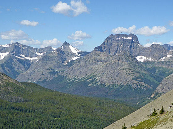
The trail heads west/northwest on easy grades through meadows and willow thickets with fine views of a long ridge paralleling the north side Highway 2. Little Dog Mountain (8,610-ft.) and Summit Mountain (8,770-ft.) tower above the western end of the ridge while Calf Robe Mountain (7,948-ft.) anchors the east end of the wall. Our trail will loop around Calf Robe’s north ridge and then climb to Firebrand Pass, a saddle on the ridge between Calf Robe and Red Crow Mountain (7,891-ft.)
The open terrain offers views stretching south to Elk Calf Mountain. Nearer at hand are a few small ponds and marshy areas along Coonsa Creek, located to the left (south/southwest) of the trail.
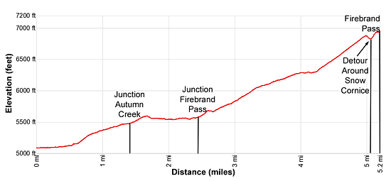
At 0.6 miles the trail enters a grove of Aspen trees and starts climbing above the north side of the creek. Soon the aspen give way to pines as the ascent abates a bit, ascending on moderately-easy grades to a junction with the Autumn Creek trail at 1.5 miles. Turn right (north) on the Autumn Creek trail toward Firebrand Pass.
The wooded path now climbs over a low hill and then descends gently. The trees give way to intermittent meadows at 1.8 miles. In season the meadows are awash in wildflowers.
At 2.3 miles the trail starts ascending on easy grades and reaches a junction at 2.4 miles. Here the Autumn Creek trail continues straight ahead (north). We bear left (northwest) on the Firebrand Pass Trail. The open meadows around the junction feature nice views of Dancing Lady Mountain rising to the north.
Beyond the junction the trail ascends on moderate grades along the east facing slopes of Calf Robe Mountain’s north ridge. Lush meadows with waist high vegetation are interspersed with clusters of trees.
At 3.1 miles the trail starts curving to the west around the end of the ridge, traveling through meadows and areas of stunted trees. Along the way enjoy views of Dancing Lady Mountain and Peak 7,695-ft. Soon views open west to Peak 8,102-ft. anchoring the northwest end of the cirque at the head of the Railroad Creek valley.
At 3.9 miles the trail starts swinging southwest around the end of the ridge. The grade briefly abates as the trail travels along talus slopes. Here views open to Red Crow Mountain (7,891-ft.) rising to the south of Peak 8,102-ft. Rugged crags jut from the ridge above the trail. Closer-at-hand small wildflowers grow amid the talus.
At 4.1 miles the ascent resumes, now through rocky meadows along the ridge’s west facing slopes. Ahead Firebrand Pass, the saddle on the ridge between Calf Robe and Red Crow Mountain, is in view. The pass is located along the head of the large cirque ringing the upper Railroad Creek Valley. Calf Robe Mountain anchors the cirque to the south while Peak 8,102-ft. and Peak 7,891-ft. define the northern wall.
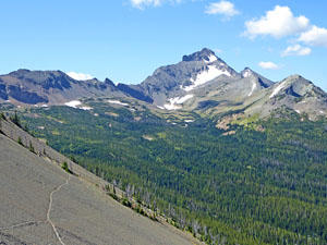
The trail now climbs the cirque’s south slopes on moderately-steep grades through meadows and then talus. A few switchbacks facilitate the climb. Along the way enjoy fine views of Red Crow Mountain, Peak 8,102-ft. and Peak 7,891-ft. Calf Robe Mountain towers overhead. As you near the head of the basin the trail curves to the west below Calf Robe Mountain’s north facing slopes.
Snow cornices remain well into the season along the talus slopes just below the pass. Some parties circumvent the obstacles by climbing the extremely steep talus slopes above the trail. I prefer following one of the many boot-beaten paths leading toward the center of the basin. Here the snow cornice melts earlier, leaving openings where a number of routes climb steeply up the talus slopes to the pass.
Late in the season you can follow the established trail that reaches Firebrand Pass (6.951-ft.) at 5.1 miles. The detour around the cornice will add 0.1 miles to the journey.
As you crest the pass a great views unfold to the high peaks towering above the Ole Creek Valley. Barrier Buttes, Peak 8,888-ft., Brave Dog Mountain (8,460-ft.) and Sheep Mountain (8,569-ft.) fill the skyline along the west side of the valley while Summit Mountain and the tip of Little Dog Peak dominate the view along the east side of the valley. Walk to the southwest side of the saddle for the best views.
The trail continues over the pass, dropping down to and crossing Debris Creek. Past the creek the trail travels through forest to the east of the creek, reaching Ole Lake and campground at 7.7 miles.
My advice is to enjoy the views from the pass and then retrace your steps to the trailhead for a 10.2 miles round trip hike.
Note: There are several routes that descend from the pass through the middle of the basin and eventually meet up with the main trail before it loops around the end of the north ridge. The routes are braided and quite faint in places. I only recommend this alternative return for hikers with route finding experience.
Elevation Profile
Driving Directions
From East Glacier, MT: From the intersection of US Highway 2 and MT-49 N in East Glacier, drive south on U.S. 2 W for 6.2 miles and then turn right into a gravel pullout/parking area along the right (west) side of the highway. The turn is across from mile marker 203. Carefully cross the train tracks to the signed Lubec trailhead. (GPS: 48.371668, -113.279516) Note: The turn is 0.4 miles past Lubec Lake, located along the west side of the highway.
From West Glacer, MT: Drive northeast on U.S. 2 E for 48.6 miles and the turn left into a gravel pullout/parking area along the left (west) side of the highway. The turn is east of Marias Pass, across from mile marker 203. Carefully cross the train tracks to the signed Lubec trailhead. (GPS: 48.371668, -113.279516) You’ve gone too far if you pass Lubec Lake, located along the west side of the highway.
Trail Resources
Trail Intro / Trail Photo Gallery / Trail Map
Basecamp(s) Information:
Two Medicine
Region Information:
Glacier Natl Park, MT
Other Hiking Regions in:
Montana